SOUTHWEST MONSOON
- The southwest monsoon is a seasonal weather pattern that brings significant rainfall to large parts of South Asia, particularly India, between June and September
- The southwest monsoon typically begins in early June and lasts until late September. It starts with the arrival of the monsoon winds in the southern part of India, usually marked by the onset over the state of Kerala
- The southwest monsoon brings about 70-90% of India’s annual rainfall. The distribution of rainfall varies, with some regions receiving heavy rains, while others may experience scanty showers.
- The Western Ghats, the northeastern states, and the Himalayan foothills typically receive very heavy rainfall.
- The monsoon is critical for the Kharif crop season in India, which includes crops like rice, maize, pulses, and cotton. Adequate and timely monsoon rains are essential for a good harvest
- The monsoon starts retreating from northwestern India in early September and completely withdraws from the Indian subcontinent by mid-October. This phase is also known as the retreating or northeast monsoon
Mechanism:
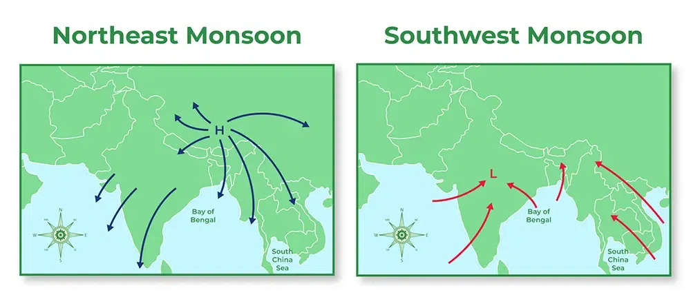
- High-Pressure Area: During the summer, intense heating of the landmass in the Indian subcontinent creates a low-pressure area over northern India and the Tibetan Plateau.
- Low-Pressure Area: The Indian Ocean remains relatively cooler, creating a high-pressure area.
- Wind Movement: Air moves from the high-pressure area over the ocean to the low-pressure area over the land, carrying moisture from the ocean and resulting in rainfall.
- Easterly and westerly winds refer to the direction from which the winds originate
- Easterly winds are winds that blow from the east towards the west
- Easterly winds can affect weather patterns, including the development of tropical storms and cyclones. For instance, easterly waves in the tropics can lead to the formation of tropical cyclones in the Atlantic and Pacific Oceans
Characteristics:
- Trade Winds: One of the most well-known examples of easterly winds are the trade winds. These winds blow from the east towards the west in the tropics, from the subtropical high-pressure areas toward the equatorial low-pressure areas.
- Tropical Regions: In the tropical regions, particularly between 30 degrees north and south of the equator, easterly winds are prevalent. These are crucial for the weather patterns and climatic conditions in these regions.
- Monsoon Winds: During certain seasons, such as the northeast monsoon in India, easterly winds play a significant role. These winds bring dry air from the land towards the ocean during the winter months.
- Westerly winds are winds that blow from the west towards the east
- Westerly winds play a significant role in the weather of temperate regions, influencing the climate and the movement of storm systems.
- They are also responsible for carrying warm and moist air from the oceans inland, affecting precipitation patterns in coastal and inland regions.
- The westerlies can affect transoceanic travel and weather prediction due to their influence on the movement of high and low-pressure systems
Characteristics:
- Prevailing Westerlies: These winds are predominant in the mid-latitudes (between 30 and 60 degrees north and south of the equator). They blow from the subtropical high-pressure belts towards the poles.
- Jet Streams: High-altitude westerly winds known as jet streams are important in influencing weather patterns and the movement of weather systems across the globe. They are fast flowing and occur in the upper levels of the atmosphere.
- Polar Front: In the mid-latitudes, the westerlies interact with polar easterlies near the polar front, leading to the development of extratropical cyclones and storms
.jpg)
Monsoons in India occur due to seasonal changes in wind patterns and temperature differences between land and sea.
Here's a concise explanation of the process:
- Differential heating: During summer, the Indian landmass heats up more quickly than the surrounding Indian Ocean.
- Low pressure system: The heated land creates a low-pressure area over the Indian subcontinent.
- Wind direction shift: This low pressure draws in moisture-laden winds from the cooler Indian Ocean towards the land.
- Orographic lift: As these winds encounter geographical features like the Western Ghats or the Himalayas, they are forced to rise.
- Condensation and precipitation: The rising air cools, causing water vapor to condense and form clouds, leading to heavy rainfall.
- Duration: This pattern typically lasts from June to September, bringing the majority of India's annual rainfall.
- The primary driver is the temperature difference between the land and the surrounding sea. During summer, the land heats up faster than the ocean, creating a low-pressure area over the land and a high-pressure area over the ocean. This pressure difference leads to the movement of moist air from the ocean to the land
- Warm sea surface temperatures are crucial as they increase the evaporation rate, contributing to the formation of moist air masses that drive the monsoon rains.
- The monsoon winds, which are part of the larger atmospheric circulation, shift according to the seasonal temperature differences. The southwest monsoon, for instance, is driven by the southwest winds that carry moisture from the Indian Ocean to the Indian subcontinent.
- The geographical features, such as mountain ranges, play a significant role. For example, the Western Ghats in India force moist air to rise, cool, and condense, leading to heavy rainfall on the windward side
- The movement and strength of the high-pressure systems over the oceans and low-pressure systems over the land influence the intensity and timing of the monsoon.
- Phenomena such as El Niño and La Niña can affect the strength and timing of the monsoon. For example, El Niño can lead to weaker monsoons due to altered wind patterns and sea surface temperatures
- El Niño is generally associated with a weaker Indian monsoon. The warming of the central and eastern Pacific Ocean during El Niño tends to disrupt the normal atmospheric circulation patterns, leading to reduced rainfall over the Indian subcontinent.
- The onset of the monsoon can be delayed, and the overall intensity of the rainfall during the monsoon season might be lower than usual
- El Niño often brings drier conditions to Southeast Asia and northern Australia, leading to droughts and reduced rainfall
- Eastern and southern Africa may experience drier conditions as well
- La Niña, characterized by cooler-than-average sea surface temperatures in the central and eastern Pacific Ocean, is typically associated with a stronger Indian monsoon. It often leads to increased rainfall over the Indian subcontinent
- The enhanced monsoon can lead to heavier rains and potentially more frequent and intense flooding
- La Niña tends to bring wetter conditions to Southeast Asia and northern Australia, potentially causing heavy rains and flooding
- La Niña can lead to wetter conditions in parts of northern South America
|
For Prelims: Indian and World Geography
For Mains: GS-I, GS-III: Important Geophysical phenomena and environment
|
|
Previous Year Questions
1.Consider the following statements: (UPSC CSE 2012)
1. The duration of the monsoon decreases from southern India to northern India.
2. The amount of annual rainfall in the northern plains of India decreases from east to west.
Which of the statements given above is/are correct?
A. 1 Only
B. 2 Only
C. Both 1 and 2
D. Neither 1 nor
Answer (C)
|
MANGROVES
- Mangroves are a special category of vegetation made up of salt-tolerant trees and shrubs that typically grow in coastal zones where freshwater from rivers and streams mixes with seawater — specifically in estuarine and intertidal environments.
- These plants are known for their specialized breathing or aerial roots and thick, waxy leaves, and they belong to the category of flowering plants.
- Mangroves flourish in regions that receive high annual rainfall ranging from 1,000 to 3,000 mm and have temperatures between 26°C and 35°C.
- A remarkable feature of mangroves is their method of reproduction. Their seeds, called propagules, begin germinating while still attached to the parent plant — a process termed vivipary.
- Once matured, these seedlings fall into the water and eventually establish themselves in muddy, sediment-rich environments. This adaptation enhances their survival in highly saline and unstable coastal conditions.
- Species like the red mangrove (Rhizophora), Avicennia marina, and the grey mangrove are among the commonly found varieties. These ecosystems are typically found in marshes and swamps and are classified as littoral forests, thriving in saline or brackish waters along coastal belts.
Mangrove Distribution in India
.png)
- Mangrove forests are found across 123 countries and territories, predominantly within tropical and subtropical latitudes.
- According to the Indian State of Forest Report (ISFR) 2023, India’s mangrove cover stands at approximately 4,992 square kilometers, making up about 0.15% of the nation’s total geographical area.
- West Bengal leads with the most extensive mangrove area, particularly in the Sundarbans. Gujarat ranks second, with about 1,177 sq. km, especially concentrated around the Gulf of Kutch and Gulf of Khambhat. Within Gujarat, Kutch district alone accounts for nearly 794 sq. km, the highest in the state.
- Other Indian states with significant mangrove ecosystems include Andhra Pradesh (notably in the Godavari-Krishna delta), Kerala, and the Andaman and Nicobar Islands.
- The Sundarbans, extending across India and Bangladesh, represent the largest continuous mangrove forest on the planet and have been designated a UNESCO World Heritage Site.
- This biodiverse region is home to iconic species such as the Royal Bengal tiger and Gangetic dolphin. In contrast, Bhitarkanika, the second largest mangrove area in India, is well known for hosting Olive Ridley turtles and saltwater crocodiles, both considered ecologically significant and vulnerable species
- Coastal Protection (Natural Bio-shields):
Mangroves serve as a natural buffer against coastal hazards. Often termed ‘bio-shields’, these dense root systems absorb and reduce the intensity of storm surges, tidal waves, and high winds. They effectively minimize soil erosion and protect vulnerable coastlines from the impacts of climate-induced disasters. - Carbon Sequestration:
These forests are highly effective carbon sinks, meaning they absorb more carbon dioxide than they emit. According to UNESCO, one hectare of mangrove can store approximately 3,754 tonnes of carbon, equivalent to removing over 2,650 vehicles from the road for a year. - Unlike other trees that release stored carbon when they die, mangroves trap carbon in the underlying soil, where it can remain locked for thousands of years, even if the vegetation above is destroyed. This makes mangroves uniquely effective in combating global warming and contributing to long-term climate stability
- Livelihood and Economic Contributions:
Being located in coastal areas, mangroves are closely tied to the livelihoods of local communities. Activities such as fishing, aquaculture, collection of honey, non-timber forest produce, and small-scale boating are directly supported by these ecosystems. - Furthermore, mangroves support the growth of commercially valuable species like fish, shrimps, and prawns, making them critical for the blue economy
- Biodiversity Hotspots:
Mangrove ecosystems are teeming with life and support complex, interdependent communities. They act as nursery grounds for marine species, shelter for terrestrial animals like monkeys, deer, and birds, and feeding grounds for a variety of organisms. - Their flowers provide nectar for honeybees, while the dense vegetation offers refuge for endangered and migratory species alike. Some mangrove zones even support unusual inhabitants such as kangaroos in other parts of the world
- As per UNESCO, mangrove forests—despite their ecological and economic importance—are vanishing at a rate three to five times faster than other global forest types. This alarming trend has far-reaching environmental and socio-economic consequences. Over the past four decades, global mangrove cover has been reduced by half.
- Multiple human-induced pressures such as deforestation, pollution, and the construction of dams significantly endanger these ecosystems.
- Additionally, climate change has emerged as a critical threat, intensifying the risks through rising sea levels and the increased frequency of extreme weather events like storms and cyclones.
- Studies suggest that as sea levels rise, mangroves naturally migrate inland. However, this landward shift is increasingly being obstructed by urban development, human settlements, and industrial infrastructure, leaving the mangroves with no space to adapt.
- This "coastal squeeze" could eventually lead to their irreversible decline, hampering both conservation and restoration efforts.
- According to research based on the IUCN Red List of Ecosystems, nearly one-third (33%) of the world’s mangrove habitats are currently at risk due to the impacts of climate change.
- The study highlights that preserving healthy mangrove ecosystems is vital to climate resilience, as they can better adapt to rising seas and provide natural protection to inland areas from storm surges, hurricanes, and cyclones
- Mangrove ecosystems are under significant stress due to rapid urban expansion, conversion of coastal areas for agriculture and shrimp farming, and the detrimental effects of rising sea surface temperatures. Additionally, unsustainable tourism activities have further exacerbated the degradation of these fragile habitats.
- On a positive note, the role of mangroves in climate change mitigation and adaptation is increasingly being acknowledged worldwide. Among notable international efforts are the Mangroves for the Future (MFF) initiative and the Mangrove Alliance for Climate, both of which focus on conservation and resilience-building.
|
Government Initiatives In India, several government-led programmes have emerged to promote mangrove protection. These include:
|
|
Despite these efforts, there is a pressing need to go beyond schemes and adopt a multi-pronged conservation strategy. This includes:
|
6. Way forward
Identifying local and regional challenges is essential to developing targeted solutions. Ultimately, there is a need for a unified global action plan with clearly defined objectives to ensure the long-term survival of mangrove ecosystems and promote a sustainable and climate-resilient future
|
For Prelims: IUCN Red List of Ecosystems, Mangroves for the Future (MFF), Mangrove Ecosystems and Their Distribution in India
For Mains: GS III - Environment and ecology
|
|
Previous Year Questions
1.Which one of the following regions of India has a combination of mangrove forest, evergreen forest and deciduous forest? (UPSC CSE 2015) (a) North Coastal Andhra Pradesh (b) South-West Bengal (c) Southern Saurashtra (d) Andaman and Nicobar Islands
2.With reference to the mangroves, consider the following statements: 1. They act as a buffer between the ocean and the land. 2. They prevent erosion by absorbing wave action. 3. Mangroves require carbon dioxide for their roots to survive. 4. Pichavaram Mangrove Forest is located in West Bengal. How many of the statements given above is/are correct? (a) Only one (b) Only two (c) Only three (d) All four 3.With reference to the Sundarbans mangrove forest, consider the following statements: 1. It lies on the delta of the Ganges, Brahmaputra and Meghna rivers on the Bay of Bengal. 2. It is a World Heritage site which was inscribed in 1987. 3. It lies on the India-Myanmar border. 4. It is the world’s second-largest contiguous mangrove forest. How many of the statements given above is/are correct? (a) Only one (b) Only two (c) Only three (d) All four Answers: 1-d 2-b 3-b Mains Discuss the causes of depletion of mangroves and explain their importance in maintaining coastal ecology. (UPSC CSE 2019) |
MONSOON AND FOOD INFLATION
- Monsoons in India are a vital weather phenomenon that brings heavy rainfall to the Indian subcontinent.
- The monsoon season typically lasts from June to September, covering various regions of India.
- It plays a crucial role in the country's agriculture, water supply, and overall economy
- The monsoons in India are a seasonal change in the direction of the prevailing winds that bring heavy rains to the country.
- The summer monsoon, which is the main monsoon in India, typically begins in June and ends in September
- This is the main monsoon in India. It brings heavy rains to the country from June to September. The southwest monsoon is caused by the difference in temperature between the land and the ocean.
- During the summer, the land heats up more than the ocean, which creates a low-pressure area over the land. This low-pressure area draws in moist air from the southwest Indian Ocean.
- As the moist air rises over the land, it cools and condenses, forming clouds and rain
- The southwest monsoon winds blow from the Indian Ocean, carrying moisture and rain clouds towards the Indian subcontinent.
- The southwest monsoon covers the entire Indian subcontinent, including the west coast, central India, northern plains, and parts of eastern India
- This monsoon brings heavy rainfall to various regions, replenishing water bodies and providing vital irrigation for agriculture
- This monsoon brings rains to India's northeast during the winter months, from October to December.
- The northeast monsoon is caused by the difference in temperature between the land and the ocean.
- During the winter, the land cools down more than the ocean, which creates a high-pressure area over the land.
- This high-pressure area pushes the moist air from the Bay of Bengal towards the land. As the moist air rises over the land, it cools and condenses, forming clouds and rain.
- During this period, the winds blow from the northeast, bringing moisture from the Bay of Bengal towards the southeastern coast of India
- The Northeast Monsoon primarily impacts the eastern coastal regions of India, including Tamil Nadu, Andhra Pradesh, parts of Karnataka, and some northeastern states
- The monsoon’s turnaround has led to a surge in kharif crop plantings – including the area under rice that was lagging behind last year’s levels till mid-July. But the gaps have since been significantly covered, barring in pulses, while forging ahead for rice
- The bulk of kharif sowings happen from mid-June to mid-August. Rainfall in June-July decides how much area is covered.
- August-September rain matters for yields of the crops already sown.
- The same rain helps fill up reservoirs and ponds and recharge groundwater tables, which provide moisture for the subsequent rabi winter-spring crops.
The monsoon has a significant impact on food inflation in India. A good monsoon ensures a good harvest, which leads to lower food prices. Conversely, a poor monsoon can lead to crop failure, which drives up food prices.
The monsoon has a significant impact on food inflation in India. Since a substantial portion of the country's agricultural production is rain-fed, the performance of the monsoon directly affects crop output and, consequently, food prices
Here are some of the ways in which the monsoon can impact food inflation:
- Crop production: The monsoon is essential for crop production in India. A good monsoon ensures that crops have enough water to grow, which leads to a good harvest. A poor monsoon can lead to crop failure, which reduces the supply of food and drives up prices.
- Input costs: The monsoon also affects the cost of inputs such as fertilizers and pesticides. A good monsoon can lead to lower input costs, which can help to keep food prices down. A poor monsoon can lead to higher input costs, which can push up food prices.
- Demand: The monsoon can also affect demand for food. A good monsoon can lead to increased demand for food, as people have more money to spend. A poor monsoon can lead to decreased demand for food, as people have less money to spend.
|
For Prelims: Southwest monsoons, retreat monsoons, inflation, food inflation
For Mains: 1.Discuss the factors influencing the onset and withdrawal of the southwest monsoon in India. How does climate change impact the monsoon pattern and what are its implications?
2.Critically assess the role of monsoon rains in replenishing water resources in India. Discuss the challenges faced in water management during both excess and deficit rainfall periods
|
|
Previous Year Questions
1.La Nina is suspected to have caused recent floods in Australia. How is La Nina different from El Nino? (UPSC CSE 2011 )
(a ) 1 only
(b) 2 only
(c) Both 1 and 2
(d) Neither 1 nor 2
Answer (d)
2. The seasonal reversal of winds is the typical characteristic of (UPSC CSE 2014 ) (a) Equatorial climate
(b) Mediterranean climate
(c) Monsoon climate
(d) All of the above climates
Answer C
3. With reference to ‘Indian Ocean Dipole (IOD)’ sometimes mentioned in the news while forecasting Indian monsoon, which of the following statements is/are correct? (UPSC CSE 2017 )
Select the correct answer using the code given below:
(a) 1 only
(b) 2 only
(c) Both 1 and 2
(d) Neither 1 nor 2
Answer b
Q7. Consider the following statements: (UPSC CSE 2015)
Which of the statements given above is/are correct?
(1) 1 only
(2) 2 only
(3) Both 1 and 2
(4) Neither 1 nor 2
Answer b
1.What characteristics can be assigned to monsoon climate that succeeds in feeding more than 50 percent of the won population residing in Monsoon Asia? (2017 GS1) 2. Discuss the nature and origin of the Indian monsoon and recent techniques of its prediction. (2014 Geography optional) 3. Discuss the mechanism and origin of Monsoon winds & explain the role of EI Nino on Monsoon circulation. (2008 Geography optional) |
FOSSIL FUELS
2. About Fossil Fuels
Fossil fuels are hydrocarbon-based energy sources derived from the remains of ancient plants and animals buried and subjected to geological processes over millions of years. The three primary types of fossil fuels are coal, oil (petroleum), and natural gas. These fuels have been pivotal in powering the industrialization and development of modern societies, serving as the mainstay for electricity generation, transportation, and numerous industrial processes.
Challenges regarding Fossil Fuels
Despite their widespread use, fossil fuels pose significant challenges:
- The combustion of fossil fuels releases carbon dioxide (CO2) and other greenhouse gases, contributing to global warming and climate change.
- Burning fossil fuels releases pollutants that degrade air quality, leading to respiratory issues and environmental damage.
- Fossil fuels are finite resources, and their extraction raises concerns about depletion and environmental degradation, such as oil spills and coal mining impacts.
- Dependence on fossil fuels, often concentrated in specific regions, raises concerns about geopolitical stability and energy security.
- The concept of achieving net-zero emissions by 2050 involves balancing the amount of greenhouse gases emitted with an equivalent amount removed from the atmosphere.
- This ambitious target aims to mitigate the impacts of climate change and limit global warming to 1.5 degrees Celsius above pre-industrial levels.
- Achieving net-zero emissions requires a transition to renewable energy, energy efficiency, and carbon capture technologies.
3. Dubai Consensus
The Dubai Consensus, adopted at COP28 in December 2023, represents a significant step forward in the global fight against climate change.
Dubai Consensus and Fossil Fuels
- The Dubai Consensus, a recent agreement, marks a significant departure by formally acknowledging that emissions from fossil fuels play a central role in driving global warming. Contrary to previous agreements that broadly addressed "greenhouse gas emissions," this marks the first explicit acknowledgement since 1995 that fossil fuels, including coal, oil, and gas, are the primary contributors to climate change.
- Despite the acknowledgement of the role of fossil fuels, particularly coal, in global warming, the Dubai Consensus does not signal an imminent end to the era of fossil fuels. Notably, it's crucial to recognize that the agreement falls short of providing specific timelines or commitments to phase out these fuels entirely.
- The Glasgow Climate Conference in 2021 marked a notable shift when countries, for the first time, agreed to address the impact of coal, the fossil fuel with the most substantial global warming footprint. However, the commitment made was to "phase down" coal rather than "phase out," and it lacked a specific termination year.
- The Dubai Consensus, by encompassing all fossil fuels, acknowledges the necessity of eliminating these energy sources to prevent a 1.5-degree Celsius rise in global average temperatures. However, the absence of concrete timelines reflects the challenges posed by varying energy needs and sources among nations.
- Large developing countries like India and China have raised objections to singling out coal, emphasizing its crucial role in lifting populations out of poverty and ensuring energy security. Both countries have substantial coal reserves, with India being a net importer. The consensus brings parity among fossil fuels, recognizing that all need eventual elimination.
4. Challenges in the Immediate Replacement of Fossil Fuels
The immediate replacement of fossil fuels poses substantial challenges, primarily due to the deeply entrenched and efficient infrastructure supporting the extraction, processing, and distribution of coal, oil, and gas. Over nearly two centuries of industrialization, a sophisticated system has evolved to convert these fossil fuels into electricity, petrol, diesel, and various other combustible products.
- Fossil fuel infrastructure is well-established, encompassing extraction, processing, and distribution networks for coal, oil, and gas.
- Power plants and refineries are optimized for the combustion of fossil fuels, contributing to the reliability and stability of energy supply.
- Fossil fuels offer on-demand availability, providing a consistent and controllable source of energy.
- Natural sources such as solar and wind, while cleaner, face challenges due to intermittency (nighttime for solar, variable wind patterns) and lack of effective energy storage infrastructure.
- Energy storage infrastructure for renewable sources is inadequate to handle the intermittency of solar and wind power, hindering their widespread adoption.
- Developing efficient and scalable energy storage solutions is crucial for transitioning away from fossil fuels.
- National plans, such as India's National Electricity Plan 2022-27, continue to include substantial additions to coal-fired capacity, highlighting the persistent reliance on fossil fuels.
- The infrastructure and investment in new coal-fired power plants reflect the ongoing challenges in immediately replacing fossil fuels.
- The Dubai Consensus acknowledges the necessity of transitioning away from fossil fuels but suggests the potential role of "transition fuels" to facilitate the process while ensuring energy security.
- While the consensus does not define these fuels, natural gas is considered a contender due to its lower emissions compared to coal. However, concerns exist regarding methane emissions associated with natural gas production.
- The COP deliberations face challenges due to the substantial presence of oil and gas manufacturers. Hosting a climate summit in a petro-state adds complexity to addressing the transition from fossil fuels.
- Natural gas, often considered a transition fuel, has advantages in reducing emissions when producing electricity and providing heat. However, criticisms argue that framing natural gas in this context may disproportionately benefit countries with existing production and distribution capabilities.
5. Dubai Consensus on Methane Emissions
- The Dubai Consensus underscores the critical importance of addressing methane emissions, recognizing methane as a potent greenhouse gas with significantly higher heat-trapping capabilities than carbon dioxide. The consensus acknowledges that substantial and accelerated reductions in non-carbon-dioxide emissions, particularly methane emissions, are essential to limit global warming and prevent average temperatures from exceeding a 1.5-degree Celsius increase by the end of the century.
- The agreement emphasizes the need for urgent action, setting a target for humanity to significantly reduce methane emissions by the year 2030. It aligns with the Global Methane Pledge, signed by nearly 150 countries at the COP-27 summit held in Egypt the previous year. The pledge commits countries to cut methane emissions by 30% of 2020 levels by the end of this decade.
- China and the United States, two major global players, have taken specific steps to address industrial methane emissions resulting from natural gas production. This collaborative effort signifies a shared commitment to tackling a significant source of methane release and contributing to the global reduction target.
- India, while resisting external pressure to cut methane emissions, has outlined plans to enhance the efficiency of its energy production processes. The nation contends that a substantial portion of its methane emissions originates from the agricultural sector. Despite resistance, India's commitment to making energy production more efficient aligns with the broader goal of reducing greenhouse gas emissions.
|
For Prelims: Fossil Fuels, Cop 28, Net zero emission, air pollution, Dubai Consensus, Global Methane Pladge, India's National Energy Plan, climate change
For Mains:
1. Discuss the challenges and opportunities associated with transitioning away from fossil fuels to achieve net-zero emissions by 2050. (250 Words)
2. Discuss the potential economic benefits of transitioning to a green economy. How can this transition create new jobs and opportunities? (250 Words)
|
|
Previous Year Questions
1. The UN Framework Convention on Climate Change (UNFCCC) has announced which country to host the 28th Conference of the Parties (COP28) in 2023? (SSC CGL 2023) A. UAE B. US C. UK D. Russia
2. The United Nations Framework Convention on Climate Change (UNFCCC) is an international treaty drawn at (UPSC 2010) A. United Nations Conference on the Human Environment, Stockholm, 1972 B. UN Conference on Environment and Development, Rio de Janeiro, 1992 C. World Summit on Sustainable Development, Johannesburg, 2002 D. UN Climate Change Conference Copenhagen, 2009
3. UNFCCC (United Nations Framework Convention on Climate Change) entered into from - (Sr. Teacher Gr II NON-TSP G.K. 2018) A. 21 March 1994 B. 5 June 1992 C. 12 May 1991 D. 5 June 1993
4. The 'Paris Agreement' adopted in Conference of the Parties (COP 21) in December 2015 will be effective provided the document is signed by: (UPSC CAPF 2016) A. 51 UNFCCC parties accounting for at least 51% of global greenhouse gas emission
B. 51 UNFCCC parties accounting for at least 55% of global greenhouse gas emission
C. 55 UNFCCC parties accounting for at least 55% of global greenhouse gas emission
D. 75 UNFCCC parties accounting for at least 51% of global greeenhouse gas emission
5. The term ‘Intended Nationally Determined Contributions’ is sometimes seen in the news in the context of (UPSC 2016) (a) pledges made by the European countries to rehabilitate refugees from the war-affected Middle East
6. With reference to the Agreement at the UNFCCC Meeting in Paris in 2015, which of the following statements is/are correct? (UPSC 2016)
Select the correct answer using the code given below. (a) 1 and 3 only (b) 2 only (c) 2 and 3 only (d) 1, 2 and 3
7. Consider the following statements with reference to Organisation for Economic Co-operation and Development (OECD): (RBI Grade B 2022) 1. OECD is an official Permanent observer to the United Nations and is referred to as a think-tank or as a monitoring group.
2. India is not a member of OECD.
3. OECD is funded by its member countries.
Which of the statement given above is/ are correct? A.1 only B.1 and 2 only C.2 and 3 only D.1, 2 and 3 E.2 only Answer: D 8. Which one of the following is associated with the issue of control and phasing out of the use of ozone-depleting substance? (UPSC CSE 2015) A.Bretton woods conference
B. Montreal Protocol
C. Kyoto Protocol
D. Nagoya Protocol
Answer: B
9. Headquarters of the World Meteorological Organization is located in (NDA 2017)
A. Washington
B. Geneva
C. Moscow
D. London
Answer: B
10. With reference to the Agreement at the UNFCCC Meeting in Paris in 2015, which of the following statements is/are correct? (UPSC 2016)
1. The Agreement was signed by all the member countries of the UN and it will go into effect in 2017
2. The Agreement aims to limit greenhouse gas emissions so that the rise in average global temperature by the end of this century does not exceed 2°C or even 1.5°C above pre-industrial levels.
3. Developed countries acknowledged their historical responsibility in global warming and committed to donate $ 1000 billion a year from 2020 to help developing countries to cope with climate change.
Select the correct answer using the code given below:
A. 1 and 3 only B. 2 only C. 2 and 3 only D. 1, 2 and 3
Answer: B
11. A new type of El Nino called El Nino Modoki appeared in the news. In this context, consider the following statements: (UPSC 2010)
1. Normal El Nino forms in the Central Pacific ocean whereas El Nino Modoki forms in the Eastern Pacific ocean.
2. Normal El Nino results in diminished hurricanes in the Atlantic ocean but El Nino Modoki results in a greater number of hurricanes with greater frequency.
Which of the statements given above is/are correct?
A. 1 only B. 2 only C. Both 1 and 2 D. Neither 1 nor 2
Answer: B
12. La Nina is suspected to have caused recent floods in Australia. How is La Nina different from El Nino? (UPSC 2011)
1. La Nina is characterized by unusually cold ocean temperature in the equatorial Indian Ocean whereas El Nino is characterized by unusually warm ocean temperature in the equatorial Pacific Ocean.
2. El Nino has an adverse effect on the south-west monsoon of India, but La Nina has no effect on the monsoon climate.
Which of the statements given above is/are correct?
A. 1 only B. 2 only C. Both 1 and 2 D. Neither 1 nor 2
Answer: D
13. Consider the following statements: (MPSC 2017)
a. La Nina is a little girl.
b. During the time of La Nina cold water in the ocean rises to the surface.
c. La Nina strengthens the Indian monsoon.
d. During the time of El Nino, trade winds weaken, and warm water moves east in the ocean. Which of the above statements is/are correct?
A. Only a and b B. a, b and c C. Only b and c D. All of the above
Answer: D
14. Which of the following statements regarding 'Green Climate Fund' is/are correct? (UPSC 2015)
1. It is intended to assist the developing countries in adaptation and mitigation practices to counter climate change.
2. It is founded under the aegis of UNEP, OECS, Asian Development Bank and World Bank. Select the correct answer using the code given below.
A. 1 only B. 2 only C. Both 1 and 2 D. Neither 1 nor 2
Answer: A
15. In the context of any country, which one of the following would be considered as part of its social capital? (UPSC 2019)
A. The proportion of literature in the population
B. The stock of its buildings, other infrastructure and machines
C. The size of population in the working age group
D. The level of mutual trust and harmony in the society
Answer: D
16. The International Development Association, a lending agency, is administered by the (UPSC 2010)
A. International Bank for Reconstruction and Development
B. International Fund for Development
C. United Nations Development Programme.
D. United Nations Industrial Development Organization
Answer: A
Answers: 1-A, 2-B, 3-A, 4-C, 5-B, 6-B, 7-D, 8-B, 9-B, 10-B, 11-B, 12-D, 13-D, 14-A, 15-D, 16-A
Mains
1. Describe the major outcomes of the 26th session of the Conference of the Parties (COP) to the United Nations Framework Convention on Climate Change (UNFCCC). What are the commitments made by India in this conference? (UPSC 2021)
|
STRAIT OF HORMUZ
.png)
-
The Strait of Hormuz is a strategically significant and narrow maritime passage situated between Iran and Oman, serving as a link between the Persian Gulf, the Gulf of Oman, and the Arabian Sea. The U.S. Energy Information Administration (EIA) has labeled it as the world’s most vital oil transit chokepoint, through which nearly 20% of global liquid petroleum fuels and a substantial portion of LNG trade pass. In May, more than 45% of India’s crude oil imports were estimated to have transited through this strait. Given that India is the third-largest consumer of crude oil globally and imports over 85% of its oil needs, the strait plays a crucial role in its energy security.
-
Data from the commodity analytics firm Kpler indicates that, as of June, India has been importing over 2.2 million barrels per day (bpd) of crude oil from Russia, which constitutes more than 41% of its total oil imports.
-
While oil imports from the U.S. have shown a steady rise, supplies from West Asian nations such as Iraq, Saudi Arabia, the UAE, and Kuwait have remained relatively consistent. Many of these shipments were likely planned prior to the recent escalation in tensions between Israel and Iran, and therefore, may not reflect the impact of the current geopolitical developments.
-
Over the past two to three years, India has notably adjusted its oil import strategy. Russia has emerged as India’s top crude supplier, overtaking traditional exporters from West Asia. Importantly, Russian oil bypasses the Strait of Hormuz, as it is mainly transported via alternative sea routes like the Suez Canal and Red Sea, and sometimes through the Cape of Good Hope or Pacific Ocean routes.
- The Strait of Hormuz is commonly considered the most critical maritime chokepoint in the world. It links the Persian Gulf with the Gulf of Oman and the Indian Ocean, serving as a major export corridor for regional oil producers.
- At its narrowest point, it measures only about 21 nautical miles (38 km) across. Under typical conditions, nearly 21 million barrels of oil—around one-fifth of global consumption—flow through it daily.
- Alongside crude oil, substantial quantities of liquefied natural gas from Qatar and the UAE are transported via this passage.
- A significant share, close to 80%, is destined for Asian markets, making countries like India, China, Japan, and South Korea heavily reliant on this route.
- Apart from Hormuz, international trade depends on a few other strategically vital maritime passages, including the Strait of Malacca, Bab el-Mandeb Strait, Suez Canal, and Panama Canal.
- The Strait of Malacca lies between the Malay Peninsula and Indonesia’s Sumatra island and represents the shortest maritime route connecting the Indian Ocean with the South China Sea. This makes it indispensable for trade flows linking West Asia, Africa, and East Asia.
- The Bab el-Mandeb Strait is positioned between the Arabian Peninsula and the Horn of Africa.
- It serves as the southern entrance to the Red Sea, a necessary transit point for vessels heading toward the Suez Canal and onward to the Mediterranean, thereby forming a crucial segment of Asia–Europe trade routes.
- The Suez Canal, a man-made channel across Egypt, connects the Red Sea to the Mediterranean Sea, significantly reducing travel time by eliminating the need to circumnavigate Africa.
- Further west, the Panama Canal cuts through the Isthmus of Panama, linking the Atlantic and Pacific Oceans. This strategic shortcut facilitates trade between Asia, the Americas, and Europe, removing the necessity of sailing around South America
-
India’s current oil procurement approach already demonstrates a diversified and risk-mitigated strategy, especially in light of uncertainties in West Asian oil routes, with Russian crude now making up the largest share of India’s import basket.
-
After recent U.S. air strikes targeting Iranian nuclear sites, Iran’s parliament passed a resolution on Sunday advocating the closure of the Strait of Hormuz, a vital corridor for global oil transportation. The final decision on this move now lies with Iran’s Supreme National Security Council.
-
Although Iran has repeatedly issued threats in the past to shut the strait, it has never acted on them. Even in the present context, industry analysts consider the likelihood of an actual blockade to be low. Nevertheless, the increased risk perception surrounding the potential closure is expected to trigger global alarm, including in India, by raising concerns over the security of oil and gas supplies and potentially driving up global energy prices.
- The Israel-Iran conflict poses a significant threat to global oil and gas flows due to the geopolitical sensitivity and strategic location of the region. At the heart of this issue lies the Strait of Hormuz—a narrow but crucial maritime passage through which nearly 20% of the world’s petroleum and a substantial share of liquefied natural gas (LNG) are transported.
- Iran borders this strait and has, over the years, repeatedly threatened to block it during periods of heightened tension, including in response to military actions or sanctions.
- When hostilities between Israel and Iran escalate—such as through air strikes, proxy conflicts, or cyber warfare—it increases the likelihood of retaliation from Iran that could involve disrupting maritime traffic in the Strait of Hormuz.
- Even if Iran does not fully close the strait, the mere threat or perception of such an action is enough to cause volatility in global energy markets. Tanker insurance rates rise, shipping routes are reconsidered, and countries heavily dependent on oil imports, like India, become increasingly vulnerable to supply disruptions and price shocks.
- Furthermore, any military conflict in this region risks damaging key infrastructure such as refineries, pipelines, or export terminals in the broader West Asian region.
- This would constrain oil production and distribution, affecting both the availability and price of crude oil and gas worldwide. Global markets respond quickly to these risks, often resulting in immediate spikes in prices due to concerns over supply security.
- In summary, the Israel-Iran conflict amplifies the risk to global oil and gas flows by potentially destabilizing a region that is central to global energy supply chains. It heightens fears of supply disruptions, increases market speculation, and threatens the economic stability of energy-importing countries, making it a matter of both geopolitical and economic concern
The flow of vessels through major international chokepoints is largely regulated by the United Nations Convention on the Law of the Sea. According to its provisions, straits that are used for global navigation fall under the concept of “transit passage,” which permits ships and aircraft from all countries to move through them freely, continuously, and without interference.
At the same time, coastal states bordering these straits are allowed to introduce regulations related to safety or environmental protection. However, they are not permitted to block passage or apply discriminatory restrictions on specific vessels. While this freedom of navigation is widely accepted in international law, its practical implementation often depends on the naval capabilities of states and the level of cooperation among them
|
For Prelims: Strait of Hormuz, Persian Gulf, Energy Information Administration (EIA), liquefied natural gas (LNG)
For Mains: General Studies II: Effect of policies and politics of developed and developing countries on India’s interests.
|
|
Previous Year Questions
1.Which one of the following straits is nearest to the International Date Line? (UPSC CSE 2008) (a) Malacca Strait (b) Bering Strait (c) Strait of Florida (d) Strait of Gibraltar Answer (b) The International Date Line (IDL) roughly follows the 180° longitude, which lies in the Pacific Ocean, deviating slightly to accommodate international boundaries. The Bering Strait lies between Russia and Alaska, and it is very close to the 180° meridian, making it the closest strait to the International Date Line. Here's why the other options are incorrect:
|


