NORTH KOREA'S SPACE PROGRAMME
1. Context
On May 31, 2023 a North Korean military reconnaissance satellite Malligyong1 was launched through a new type of rocket named Chollima1. The satellite is said to have flown for about 10 minutes before crashing into the Yellow Sea.
2. North Korean Space Programme
- North Korea in the past decade has had an active space program that is closely related to its missile program.
- Satellite launch vehicles use the same core technology as longrange missiles that deliver warheads capable of destroying intercontinental targets. (the Intercontinental Ballistic Missiles or ICBMs).
- Starting in 1998, North Korea successfully orbited its first satellite in 2012 after three failed attempts.
- The launch vehicle used was Unha3, a likely variant of Taepodong2 ICBM. The
Unhatype launch vehicle was also used in the 2016 launch of Pyongyang’s Earth Observation satellite. - The flight on May 31 was the sixth satellite launch by Pyongyang. It was done through the Chollima1 which is a new space launcher known to have an engine that is similar to North Korea’s dualnozzle liquidfuel machine used in Hwasong15 ICBM.
- Additionally, in April, North Korea announced that it had completed the construction of its first spy satellite.
3. Why does it want assets in Space?
- The North Korean spy satellites are expected to play a crucial role in providing advanced surveillance technology, that covers a large portion of the region, to improve the ability to strike targets during conflict.
- Kim Jong Um, the leader of North Korea, stated that the nation would have the capability to "use Preemptive military force when the station demands.
- Moreover, North Korea's space program is a response to other strategic developments in the region.
- Earlier, the U.S. announced that it would be activating U.S. Space Forces in Korea.
- This system would provide South Korea with advanced capabilities of missile warning and satellite communications throughout the Korean peninsula and its proximate war.
- South Korea successfully launched its Nuri rocket which is designed to assist Seoul's efforts to develop a space-based surveillance system.
- These developments nudged Pyongyang to hasten the launch of Malligyong 1.
4. What does this mean for East Asia?
- The security anxiety in East Asia in response to the North Korean satellite launch reveals a sense of urgency among the regional powers.
- North Korea no longer needs to develop its long-range missile technology under the guise of satellites since its testfiring in 2017.
- Pyongyang seems unafraid to reveal its technological intentions and strengthen its security apparatus in the region.
- While the launch is a breach of the UN security council resolutions, it is unlikely to attract additional economic sanctions.
- This displays the weak effectiveness of sanctions imposed on North Korea.
| For Prelims: North Korea's Space Programme, Intercontinental Ballistic Missiles or ICBMs, U.S. Space Forces, Malligyong 1, East Asia, UN Security Council, Hwasong15 ICBM. |
Source: The Hindu
FRICTION POINTS IN LAC
1. Context
As the 2020 standoff in Eastern Ladakh marks three years, India and China are far from achieving the objective of disengagement and de-escalation and restoration of the status quo ante to resolve the situation along the Line of Actual Control (LAC).
As part of the disengagement process from the friction points in Eastern Ladakh, India and China have been engaged in talks at the diplomatic, military and political levels, with the senior military commander-level talks being the major avenue to undertake disengagement and de-escalation and resolve the standoff that began in May 2020.
2. Disengagement process
- Since the Corps commander-level talks in 2020, the two sides have so far undertaken disengagement from five friction points at Galwan after the violent clash in June 2020, the north and south banks of Pangong Tso in February 2021, at Patrolling Point (PP) 17 in the Gogra-Hot Springs area in August 2021 and PP15 in September 2022.
- On the Depsang Plains and Demchok, there are fundamental disagreements, as India maintains that they terming them as legacy issues predating the 2020 standoff.
- On several occasions, the situation along the LAC as "stable but unpredictable" while stating that five out of the seven friction points in Eastern Ladakh have been resolved and the focus is now on the remaining two points.
- The 18th round of Corps Commander talks was held at the Chushul Moldo meeting point on the Chinese side on April 23, 2023.
- The Indian stance on the same was consistent, i.e. restoration of status quo ante as on April 2020.
- The above entails the restoration of patrolling rights till the traditional patrolling points.
- On May 31, 2023, India and China held the 27th Meeting of the Working Mechanism for Consultation and Coordination on India-China Border Affairs (WMCC) in New Delhi which made no headway and the two sides agreed to hold the 19th round of Corps Commanders talks very soon.
- In the past, Beijing has said that it would not accept India's demand for the restoration of the status quo ante before the standoff saying that "the status quo of April 2020 was created by India's illegal crossing of the LAC.
- Meanwhile, China has been undertaking a massive build-up of infrastructure, habitat and induction of new weapons and equipment along the 3, 488 km-long LAC, fundamentally altering the status quo on the ground.
- India too has been building infrastructure and undertaking capability enhancement to match the Chinese.
- This is in addition to the over 50, 000 troops and heavy equipment, on each side, which continue to be deployed close to the LAC in Eastern Ladakh.
- Against this backdrop, any de-escalation to restore the status quo predating the standoff looks remote.
 Image source: Indian Defence Review
3. About Buffer zones and their status
- During the disengagement process, buffer zones were created at the friction points as per the understanding reached by the Corps Commanders-level talks.
- It was decided that both sides would pull back at an equal distance from the friction points to prevent any fresh flare-ups; also, no patrolling would be undertaken by both side till the overall disengagement and de-escalation are achieved after which the two sides have to work out new patrolling norms to maintain peace and tranquillity.
- All disengagements carried out earlier have been done based on mutual and equal security with no prejudice to LAC claims by either side.
- Since the beginning of the standoff, China had moved a large number of troops and equipment close to the LAC in addition to the ingress by Chinese troops inside Indian territory at friction points.
- On the North Bank, Chinese troops made ingress from Finger 8 up to Finger 4 blocking Indian Patrols.
- India holds its place till Finger 4 but claims territory till Finger 8 as per the alignment of the LAC.
- Disengagement has been undertaken there since and buffer zones at all five points continue to be in place.
- To ensure that the Chinese are fully honouring the understanding reached, verification by aerial monitoring using Unmanned Aerial Vehicles (UAV) as well as satellites is undertaken regularly.
- During the first phase of disengagement, both sides had pulled back troops by an equal distance from Patrolling Points (PP) 14 in Galwan Valley and PP 15 in Gogra-Hot Springs during which violent clashes occurred resulting in the deaths of 20 Indian Personnel and at least five deaths on the Chinese side.
4. The strategic significance of Depsang
- Demchok is one of the two mutually agreed-disputed areas in Eastern Ladakh, while Depsang is another friction point.
- In Demchok, while there are varying claims in the Charding La area, China has set up tents on this side of Charding Nala.
- The crucial SubSector North (SSN) consists of the Depsang plains and Daulat Beg Oldie (DBO).
- Currently, the airfield at DBO is accessible by the 255 km-long Darbuk-Shyok-DBO (DSDBO) road.
- A plan for an alternate axis across Saser La which has an ancient trade route is in the works.
- In Depsang Plains, Chinese troops have been blocking Indian Army patrols from going up to the PPs 10, 11, 11A, 12 and 13 beyond the Y junction.
- Chinese build-up in this area threatens Indian positions at DBO and also brings Chinese troops closer to the DSDBO road.
- Depsang is also close to the Karakoram Pass overlooking the strategic Saltoro ridge and Siachen glacier, the World's highest battlefield.
- Senior officials have stated that the Indian Army last accessed the patrolling points in Depsang in January and February 2020.
- Also, the distance from the Limit of Patrol (LoP) on which the PPs are marked, to the LAC is the maximum in the Depsang area.
- Depsang has seen several face-offs in the past and as reported earlier, officials pointed out that as India's capacity in the areas increased, especially since 2013, the number of troops and frequency of patrols had gone up and with it the number of face-offs.
|
For Prelims: LAC, India-China, Galwan, buffer zones, Unmanned Aerial Vehicles, Patrolling Points, Depsang, DSDBO road, Karakoram Pass, Siachen glacier,
For Mains:
1. What are the differences that persist between India and China on the Depsang Plains and Demchock? Explain where have buffer zones been created during the disengagement process. (250 Words)
|
|
Previous Year Questions
1. LAC (Line of Actual Control) is an effective border between India and ______. (SSC CHSL 2021)
A. Pakistan B. Bhutan C. Sri Lanka D. China
Answer: D
2. What is/are correct among the following? (CGPSC 2022)
(i) Galwan River was named after Ghulam Rassul Galwan
(ii) Ghulam Rassul Galwan was a Laddakhi explorer
(iii) He wrote a book in English named ‘Servants of Sahibs’
A. (i), (ii) and (iii)
B. (i) and (ii)
C. (i) and (iii)
D. Only (i)
Answer: A
3. When did the clash between the soldiers of India and China take place in the Galwan Valley? (67th BPSC 2022)
A. December 2019
B. April 2019
C. January 2020
D. June 2020
E. None of the above/More than one of the above
Answer: D
4. With reference to 'Eco-Sensitive Zones', which of the following statements is/are correct? (UPSC 2014)
1. Eco-Sensitive Zones are the areas that are declared under the Wildlife (Protection) Act, 1972 2. The purpose of the declaration of Eco-Sensitive Zones is to prohibit all kinds of human activities in those zones except agriculture.
Select the correct answer using the code given below.
A. 1 only B. 2 only C. Both 1 and 2 D. Neither 1 nor 2
Answer: D
5. Consider the following statements: (UPSC 2010)
1. The boundaries of a National Park are defined by legislation.
2. A Biosphere Reserve is declared to conserve a few specific species of flora and fauna.
3. In a Wildlife Sanctuary, limited biotic interference is permitted.
Which of the statements given above is/are correct?
A. 1 only B. 2 and 3 only C. 1 and 3 only D. 1, 2 and 3
Answer: C
6. Consider the following activities: (UPSC 2020)
1. Spraying pesticides on a crop field.
2. Inspecting the craters of active volcanoes.
3. Collecting breath samples from spouting whales for DNA analysis.
At the present level of technology, which of the above activities can be successfully carried out by using drones?
A. 1 and 2 only B. 2 and 3 only C. 1 and 3 only D. 1, 2 and 3
Answer: D
7. Consider the following statements regarding Depsang Plains. (Haryana Civil Services 2021)
1. It is formed by fertile alluvium soils.
2. The plain is found at the higher altitudes.
3. It is covered with dense coniferous forests.
Which of the statements given above is/are correct?
A. 1 only B. 2 only C. 1 and 3 only D. 2 and 3 only
Answer: B
8. Karakoram a mountain range, is of great geopolitical significance as: (IB ACIO Grade II 2021)
1. It connects India and China.
2. It serves as a watershed for the basins of the Indus and Yarkand rivers.
3. The borders of India, China, Pakistan along Afghanistan and Tajikistan all converge within the Karakoram system.
Select the correct answer using the codes given below.
A. Only 1 and 2 B. Only 3 C. Only 2 and 3 D.Only 2
Answer: C
9. Siachen Glacier is situated to the (UPSC 2020)
A. East of Aksai Chin
B. East of Leh
C. North of Gilgit
D. North of Nubra Valley
Answer: D
10. Siachen glacier is located in the following range: (WBCS Prelims 2021)
A. Karakoram B. Zaskar C. Pir Panjal D. Shiwalik
Answer: A
|
Source: The Hindu
KAVACH SYSTEM
1. Context
The death of over 288 passengers in the ghastly train accident on June 2 at Bahanaga Bazaar railway station in the Balasore district of Odisha has brought into sharp focus the safety mechanisms needed to prevent such tragedies.
2. What is Kavach System?
- The KAVACH is an indigenously developed Automatic Train Protection (ATP) system by the Research Design and Standards Organisation (RDSO) in collaboration with the Indian industry.
- The South Central Railway facilitated the trials to achieve safety in train operations across Indian Railways. It is a state of heart electronic system with Safety Integrity Level-4 (SIL-4) standards.
- It is meant to protect by preventing trains from passing the signal at Red (which marks danger) and avoiding collision.
- It activates the train’s braking system automatically if the driver fails to control the train as per speed restrictions. In addition, it prevents the collision between two locomotives equipped with functional Kavach systems.
- The system also relays SoS messages during emergencies. An added feature is
the centralized live monitoring of train movements through the Network Monitor System. - ‘Kavach’ is one of the cheapest, SIL4 certified technologies where the probability of error is 1 in 10,000 years.
 Source: The Hindu
3. The key feature of Kavach
- One of its features is that by continuously refreshing a train's movement information, it can send out triggers when a loco pilot jumps signal, called Signal Passed at Danger (SPAD).
- The devices also continuously relay the signals ahead to the locomotive, making it useful for loco pilots in low visibility, especially during dense fog.
- It includes the key elements from already existing and tried and tested systems like the European Train Protection and Warning System, and the indigenous Anti Collison Device.
- It will also carry features of the high-tech European Train Control System Level-2 in the future.
- The current form of Kavach adheres to the highest level of safety and reliability standard called Safety Integrity Level 4.
4. How does Kavach work on Railway systems?
- The Traffic collision avoidance system (TCAS), with the help of equipment on board the locomotive and transmission towers at stations connected to Radio Frequency Identification (RFID) tags, helps in two way communication between the station master and locopilot to convey any emergency message.
- The instrument panel inside the cabin helps the locopilot know about the signal in advance without visual sighting and the permissible speeds to be maintained.
- If a red signal is jumped and two trains come face to face on the same line, the technology automatically takes over and applies sudden brakes.
- Additionally, the hooter activates by itself when approaching a level crossing which serves as a big boon to locopilots during fog conditions when visibility is low.
5. Kavach deployment strategy
- Kavach implementation is being taken up in a focused manner by the Railway board.
- The priority is the High-Density Routes and the New DelhiMumbai and New DelhiHowrah Sections, as they have higher chances of accidents because the trains run closer to each other.
- The second priority lines are the Highly Used Networks, the third ones are other Passenger High-Density Routes and the final priority is of course to cover all other routes.
- The RDSO has approved three firms -Medha Servo Drives, HBL, and Kernex -for providing Kavach equipment with two more being in the pipeline.
- Glitches about the vulnerability of a vehicle crossing a closed level crossing, stray cattle or boulders on track, radio communication issues in tunnels, and ghat sections have been tackled.
6. Significance of the Kavach System
- The Kavach system will help prevent accidents on rail tracks like collisions of trains.
- Once the system is activated, all trains within a 5-km range will halt to protect trains on adjacent tracks.
-
Currently, the loco-pilots or assistant loco-pilots have to look out for caution signs and signals. It will only cost Rs 50 lakh per kilometer to operate in comparison to about Rs 2 crore worldwide.
-
It will also include stationary equipment to gather signaling inputs and relay them to a central system to enable seamless communication with the train crew and stations.
|
For Prelims: Automatic Train Protection (ATP) system, KAVACH System, Research Design and Standards Organisation (RDSO), Safety Integrity Level-4 (SIL-4) standards, Signal Passed at Danger (SPAD), Traffic collision avoidance system (TCAS), and Radio Frequency Identification (RFID).
For Mains: 1. The Indigenous train collision avoidance system also known as the automatic train protection system or Kavach, is to help the railways to achieve the goal of Zero Accidents. Comment.
|
Source: The Hindu
LIGHTWEIGHT PAYMENTS FOR EMERGENCIES
1. Context
The Reserve Bank of India (RBI) has conceptualised a lightweight payment and settlements system, which it is calling a “bunker” equivalent of digital payments, which can be operated from anywhere by a bare minimum staff in exigencies such as natural calamities or war.
The infrastructure for this system will be independent of the technologies that underlie the existing systems of payments such as UPI, NEFT, and RTGS.
The central bank has not offered a timeline for the launch of this payment system yet
2.Key takeaways
- In its Annual Report for 2022-23 published on Tuesday (May 30 2023), RBI says that the lightweight and portable payment system is expected to operate on minimalistic hardware and software, and would be made active only on a “need basis”
- A lightweight and portable payment system could ensure near-zero downtime of the payment and settlement system in the country and keep the liquidity pipeline of the economy alive and intact by facilitating the uninterrupted functioning of essential payment services like bulk payments, interbank payments and provision of cash to participant institutions
- The system is expected to process transactions that are critical to ensure the stability of the economy, including government and market related transactions
- According to RBI “Having such a resilient system is also likely to act as a bunker equivalent in payment systems and thereby enhance public confidence in digital payments and financial market infrastructure even during extreme conditions,”
3. How Lightweight is different from UPI
- There are multiple payment systems available in the country for use by individuals as well as institutions, each of which has its distinct character and application
- According to the RBI, existing conventional payments systems such as RTGS, NEFT, and UPI are designed to handle large volumes of transactions while ensuring sustained availability
- As a result, they are dependent on complex wired networks backed by advanced IT infrastructure
- However, catastrophic events like natural calamities and war have the potential to render these payment systems temporarily unavailable by disrupting the underlying information and communication infrastructure
- Therefore, it is prudent to be prepared to face such extreme and volatile situations
|
For Prelims: NCPI, UPI, RBI For Mains: 1. What is RBI’s planned ‘lightweight’ payments system for emergencies? (250 words) |
Source: indianexpress
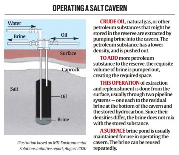
SALT CAVERN-BASED STRATEGIC OIL RESERVES
1. Context
Government-owned engineering consultancy firm Engineers India (EIL) is studying the prospects and feasibility of developing salt cavern-based strategic oil reserves in Rajasthan, in line with the government’s objective of increasing the country’s strategic oil storage capacity.
2. Key takeaways
- If the idea comes to fruition, India could get its first salt cavern-based oil storage facility.
- The country’s three existing strategic oil storage facilities at Mangaluru and Padur in Karnataka and Visakhapatnam in Andhra Pradesh are made up of excavated rock caverns
- Countries build strategic crude oil reserves to mitigate major supply disruptions in the global supply chain
- India, the world’s third-largest consumer of crude, depends on imports for more than 85 per cent of its requirement and strategic petroleum reserves (SPR) could help ensure energy security and availability during global supply shocks and other emergencies
- India currently has an SPR capacity of 5.33 million tonnes, or around 39 million barrels of crude, that can meet around 9.5 days of demand
- The country is in the process of expanding its SPR capacity by a cumulative 6.5 million tonnes at two locations Chandikhol in Odisha (4 million tonnes) and Padur (2.5 million tonnes)
- India’s strategic oil reserves come under the Petroleum Ministry’s special purpose vehicle Indian Strategic Petroleum Reserve (ISPRL)
- EIL was instrumental in setting up the country’s existing SPR as the project management consultant
- Salt cavern-based storage, which is considered cheaper and less labour- and cost-intensive than rock caverns, could add a new, much-needed chapter to India’s SPR story
3. Salt Cavern based reserves vs Rock Cavern based reserves
- Unlike underground rock caverns, which are developed through excavation, salt caverns are developed by the process of solution mining, which involves pumping water into geological formations with large salt deposits to dissolve the salt
- After the brine (water with dissolved salt) is pumped out of the formation, the space can be used to store crude oil
- The process is simpler, faster, and less cost-intensive than developing excavated rock caverns
- Salt cavern-based oil storage facilities are also naturally well-sealed, and engineered for rapid injection and extraction of oil
- This makes them a more attractive option than storing oil in other geological formations, according to a report by the Environmental Solutions Initiative at the Massachusetts Institute of Technology (MIT)
- The salt that lines the inside of these caverns has extremely low oil absorbency, which creates a natural impermeable barrier against liquid and gaseous hydrocarbons, making the caverns apt for storage
- Also, unlike rock caverns, salt cavern-based storages can be created and operated almost entirely from the surface
- The entire SPR programme of the United States has so far been based on salt cavern-based storage facilities
- The US Strategic Petroleum Reserve, the world’s largest emergency oil storage, consists of four sites with deep underground storage caverns created in salt domes along the Gulf of Mexico coast in Texas and Louisiana
- The US strategic oil reserves have a cumulative capacity of around 727 million barrels
- Salt caverns are also used to store liquid fuels and natural gas in various parts of the world. They are also considered suitable for storing compressed air and hydrogen
4. India's Potential in storing crude, petroleum products
- Rajasthan, which has the bulk of requisite salt formations in India, is seen as the most conducive for developing salt cavern-based strategic storage facilities
- Plans over the past decade to build a strategic oil reserve in Bikaner did not take off and EIL’s Chairman and Managing Director Vartika Shukla said the exploration of the possibility of salt cavern-based strategic storage in Rajasthan can be seen as a renewal of that proposal
- A refinery is coming up in Barmer, and Rajasthan has crude pipelines as well; such infrastructure is conducive to building strategic oil reserves
- However, no Indian company, including EIL, had the requisite technical know-how to build salt cavern-based strategic hydrocarbon storage
- This gap in access to technology has been bridged by EIL’s recent partnership with Germany’s DEEP
5. Strategic petroleum reserves
- India’s strategic oil reserves are part of the effort to build sufficient emergency stockpiles on the lines of the reserves that the US and its Western allies set up after the first oil crisis of the 1970s
- The three existing rock cavern-based facilities were built during the first phase of the programme
- Crude oil from the reserves is to be released by an empowered committee set up by the government, in the event of supply disruptions due to a natural calamity or an unforeseen global event leading to an abnormal increase in prices
- The International Energy Agency (IEA), a Paris-based autonomous intergovernmental organisation in which India is an ‘Association’ country, recommends that all countries should hold an emergency oil stockpile sufficient to provide 90 days of import protection
- In India, apart from the SPR that is sufficient to meet 9.5 days of oil requirement, the oil marketing companies (OMCs) have storage facilities for crude oil and petroleum products for 64.5 days which means there is sufficient storage to meet around 74 days of the country’s petroleum demand
- India has also decided to commercialise its strategic petroleum reserves, as part of which the Abu Dhabi National Oil Company (ADNOC) stored about 0.8 million tonnes of crude oil in the Mangaluru strategic reserve
- In the second phase of the programme, the government wants to develop strategic reserves through public-private partnerships so as to reduce government spending and exploit the commercial potential of the reserves
- Taking advantage of low crude oil prices in April-May 2020, the government completely filled these reserves, leading to estimated savings of around Rs 5,000 crore
- In late 2021, India released 5 million barrels from its strategic reserves as part of a coordinated US-led action by major oil-consuming countries against the joint decision of major oil-producing nations to curb output
|
For Prelims: Salt Cavern oil-based reserve advantages, Rock cavern oil-based reserves, Rock cavern oil-based reserves locations
For Mains: 1. A robust recovery in domestic demand for fuel and other petroleum products amid flat domestic crude output has led to India’s dependency on imported crude. Discuss (250 Words)
|
Source: indianexpress
ANAEMIA POLICY
1. Context
Questions related to anaemia are slated to be dropped from the National Family Health Survey (NFHS-6) is scheduled to begin on July 6.
2. Key points
- The omission comes after health experts questioned the efficacy of the method being used to estimate haemoglobin levels.
- India's anaemia burden has grown alarmingly with NFHS-5 (2019-21) finding that 57 per cent of women in the age group 15-49 and 67 per cent of children between six months and 59 months are anaemic (from the corresponding 53 per cent and 58.6 per cent respectively in NFHS-4 (2015-16).
- The Health Ministry has noted that anaemia is a public health challenge and accurate estimates are needed to tackle the crisis.
3. Causes of anaemia
- According to the World Health Organization (WHO), anaemia is a condition in which the number of red blood cells or the haemoglobin concentration within them is lower than normal.
- Haemoglobin is needed to carry oxygen and if there are too few red blood cells or not enough haemoglobin, there will be a decreased capacity of the blood to carry oxygen to the body's tissues, resulting in symptoms such as fatigue, weakness, dizziness and shortness of breath among others.
- Anaemia, according to WHO, may be caused by several factors.
- The most common nutritional cause of anaemia is iron deficiency although deficiencies in folate, vitamins B12 and A are also important causes.
- According to the Health Ministry, assessment of anaemia in India is being shifted to the new Diet and Biomarkers Survey in India (DABS-I), launched last year to map diet, nutrition and health status and provide the correct estimate of anaemia among the rural and urban population.
4. Prompted changes
- Researchers cautioned that there is a danger of anaemia being over-diagnosed in India as follows WHO cut-offs for haemoglobin which may not be suited to India because the cut-off point depends on age, gender, physiological status, altitude and other factors.
- The WHO defines anaemia in Children aged under five years and pregnant women as a haemoglobin concentration <110 g/L at sea level and anaemia in non-pregnant women as a haemoglobin concentration <120 g/L.
- The study by the Indian team also pointed to differences in the way blood is drawn for sampling in NFHS.
- The NFHS survey measured haemoglobin in a drop of capillary blood that oozes from a finger prick.
- As per the report, this can dilute the blood and give a falsely lower value. The recommended method of venous blood sampling and the report gives a more accurate value.
5. National-level dietary survey
- The Health Ministry says DABS-I is a comprehensive national-level dietary survey, which will define food and nutrient adequacy by collecting individual dietary intake data of different age groups of people from all States and UT across the country.
- The study will also provide nutrient composition data on cooked and uncooked foods from various regions of the country for the first time.
- On the other hand, NHFS provides information on population, health and nutrition for India and each State and UT.
- Besides providing evidence for the effectiveness of ongoing programmes, the data from NFHS helps in identifying the need for new programmes with an area-specific focus.
6. Reasons for focus on anaemia
- Data on anaemia remains an important indicator of public health since anaemia is related to morbidity and mortality in population groups usually considered to be the most vulnerable pregnant women and children under five.
- A prevalence study on anaemia is useful to monitor the progress of reproductive health.
- Also, iron deficiency anaemia reduces the work capacity of individuals and entire populations, with serious consequences for the economy and national development.
- The proposed method of screening under DABS-I is likely to provide better estimates of anaemia.
- There will be appropriate screening but through a different survey and we are hopeful that in the coming years, we will be able to make a dent in the prevalence of anaemia across different age groups.
- NFHS's strength lies in its ability to provide a broader understanding of the issue and facilitate evidence-based policy-making and targeted interventions.
|
For Prelims: Anaemia, NFHS, DABS-I, iron deficiency, World Health Organization, vitaminB12, vitamin A
For Mains:
1. What is Anaemia? Discuss the causes of Anaemia and Explain how it is an important indicator of public health in India. (250 Words)
|
|
Previous Year Questions
1. Which of the following are the objectives of 'National Nutrition Mission'? (UPSC 2017)
1. To create awareness relating to malnutrition among pregnant women and lactating mothers.
2. To reduce the incidence of anaemia among young children, adolescent girls, and women.
3. To promote the consumption of millets, coarse cereals, and unpolished rice.
4. To promote the consumption of poultry eggs.
Select the correct answer using the code given below:
A. 1 and 2 only B. 1, 2 and 3 only C. 1, 2 and 4 only D. 3 and 4 only
Answer: A
2. National Family Health Survey (NFHS) – 5 does not include (UPPSC 2019)
A. High blood-pressure B. Diabetes C. HIV Test D. Registration of death
Answer: C
3. What does iron deficiency lead to? (Bihar Police SI Mains 2022)
A. Beri-beri B. Scurvy C. Anaemia D. Diabetes
Answer: C
4. When did World Health Organization officially declare the South-East Asia region Polio free? (UPPSC 2014)
A. 27th March, 2014 B. 28th March, 2014 C. 29th March, 2014 D. 30th March, 2014
Answer: A
5. Sources of vitamin B-12 are (MPSC 2017)
A. Meat, Fish, Liver and Bacteria in small Intestines
B. Mushrooms, Grains and Nuts Bread, Rice,
C. Broccoli and Soyabean
D. All of the above
Answer: A
6. Consider the following pairs: (UPSC 2014)
Vitamin Deficiency disease
1. Vitamin C Scurvy
2. Vitamin D Rickets
3. Vitamin E Night blindness
Which of the pairs given above is/are correctly matched?
A. 1 and 2 only B. 3 only C. 1, 2 and 3 D. None
Answer: A
|
Source: The Hindu


