LOW EARTH ORBIT (LEO)
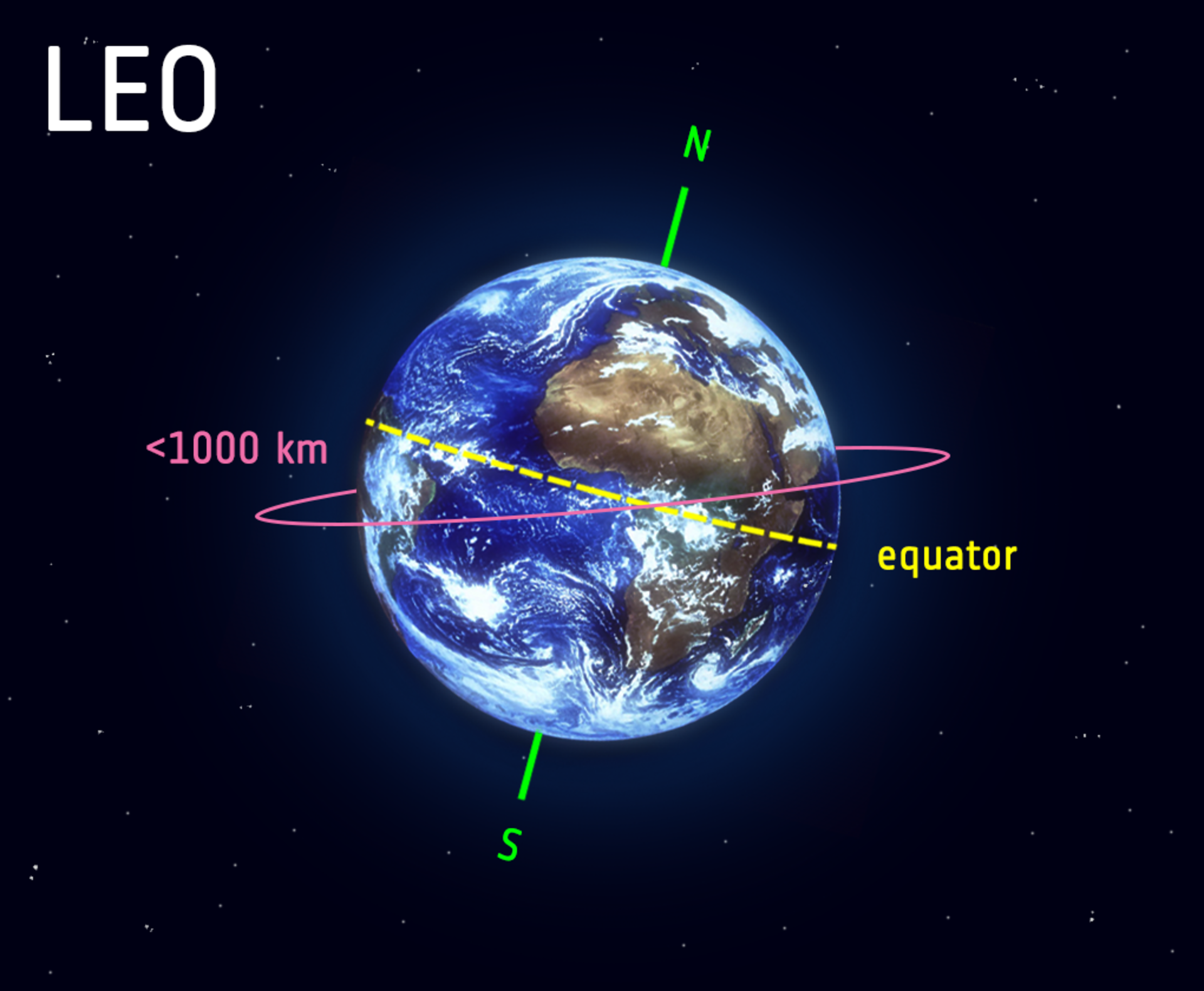
Low Earth Orbit (LEO) is an orbit around Earth with an altitude of 2,000 kilometers (1,200 miles) or less. It is the most common type of orbit for artificial satellites, and it is used for a variety of purposes, including:
- Earth observation: LEO satellites can provide high-resolution images of the Earth's surface, which can be used for a variety of purposes, such as monitoring environmental change, tracking weather patterns, and providing military intelligence.
- Communication: LEO satellites can be used to relay communications signals between different parts of the Earth. This is especially useful in remote areas that are not served by terrestrial communications infrastructure.
- Navigation: LEO satellites are used by the Global Positioning System (GPS) to provide accurate positioning information to users on the ground.
- Scientific research: LEO satellites can be used to conduct a variety of scientific experiments, such as studying the Earth's atmosphere, the Sun, and the stars.
- Shorter orbital periods: Satellites in LEO have shorter orbital periods than satellites in higher orbits. This means that they can transmit data to Earth more quickly.
- Lower communication latency: The lower orbital period of LEO satellites also means that there is lower communication latency, which is the time it takes for a signal to travel from the satellite to Earth.
- Closer to Earth: LEO satellites are closer to Earth than satellites in higher orbits. This means that they can be serviced more easily, and they are less likely to be affected by space debris.
DS-SAR stands for Dual-Speed Synthetic Aperture Radar. It is a Singaporean SAR Earth Observation satellite that was launched into orbit on July 30, 2023.
The satellite was developed and built by Israel Aerospace Industries (IAI) for the Defence Science and Technology Agency (DSTA) of Singapore.
DS-SAR is a dual-frequency SAR satellite, meaning that it can operate at two different radar frequencies: C-band and L-band.
This allows the satellite to produce images with different characteristics, depending on the frequency used. For example, C-band images are typically better at resolving fine details, while L-band images are better at penetrating clouds and other obscurants.
6.Polar Satellite Launch Vehicle (PSLV)
The Polar Satellite Launch Vehicle (PSLV) is an expendable launch vehicle developed and operated by the Indian Space Research Organisation (ISRO).
It is a three-stage, solid-and-liquid-fueled rocket that is capable of launching satellites into Low Earth Orbit (LEO), Sun-synchronous orbits, and Geosynchronous Transfer Orbit (GTO)
The PSLV has been used to launch a wide variety of satellites, including Earth observation satellites, communication satellites, and scientific satellites.
It has also been used to launch commercial satellites for customers around the world
7.Geosynchronous Satellite Launch Vehicle (GSLV)
The GSLV is an expendable launch vehicle developed and operated by the Indian Space Research Organisation (ISRO).
It is a three-stage, liquid-fueled rocket that is capable of launching satellites into geosynchronous transfer orbit (GTO)
The GSLV was first launched in 2001, and has since been used to launch a variety of satellites, including communication satellites, weather satellites, and scientific satellites
|
For Prelims: Low Earth Orbit (LEO), PSLV, GSLV
For Mains: 1.Discuss the significance of the Polar Satellite Launch Vehicle (PSLV) in India's space program. Highlight its features and capabilities that have made it a reliable and preferred launch vehicle for both domestic and international satellite missions
2.GSLV (Geosynchronous Satellite Launch Vehicle) is a crucial component of India's space endeavors. Elaborate on its design, stages, and payload capacity. Compare and contrast GSLV with PSLV in terms of their applications and advantages
|
|
Previous Year Questions
1.A low earth orbit satellite can provide large signal strength at an earth station because: (ESE Electronics 2011)
A. Path loss is low
B. These orbits are immune to noise
C. Large solar power can be generated at these orbits
D. Lower microwave frequencies in s-band can be used
Answer-A
|
PESA ACT
- The PESA Act was enacted in 1996 “to provide for the extension of the provisions of Part IX of the Constitution relating to the Panchayats to the Scheduled Areas”. (Other than Panchayats, Part IX, comprising Articles 243-243ZT of the Constitution, contains provisions relating to Municipalities and Cooperative Societies.)
- Under the PESA Act, Scheduled Areas are those referred to in Article 244(1), which says that the provisions of the Fifth Schedule shall apply to the Scheduled Areas and Scheduled Tribes in states other than Assam, Meghalaya, Tripura, and Mizoram. The Fifth Schedule provides for a range of special provisions for these areas
- The PESA Act was enacted to ensure self-governance through Gram Sabhas (village assemblies) for people living in the Scheduled Areas.
- It recognises the right of tribal communities, who are residents of the Scheduled Areas, to govern themselves through their own systems of self-government, and also acknowledges their traditional rights over natural resources
- In pursuance of this objective, the Act empowers Gram Sabhas to play a key role in approving development plans and controlling all social sectors.
- This includes the processes and personnel who implement policies, exercising control over minor (non-timber) forest resources, minor water bodies and minor minerals, managing local markets, preventing land alienation and regulating intoxicants among other things.
- State governments are expected to amend their respective Panchayati Raj Acts without making any law that would be inconsistent with the mandate of PESA
- Ten states-Andhra Pradesh, Chhattisgarh, Gujarat, Himachal Pradesh, Jharkhand, Madhya Pradesh, Maharashtra, Odisha, Rajasthan, and Telangana have notified Fifth Schedule areas that cover (partially or fully) several districts in each of these states
- After the PESA Act was enacted, the central Ministry of Panchayati Raj circulated model PESA Rules. So far, six states have notified these Rules, including Gujarat
Key features of the PESA Act include:
-
Local Self-Governance: The Act grants tribal communities in Scheduled Areas the power to manage their own local affairs through traditional institutions such as Gram Sabhas and Panchayats.
-
Customary Laws: PESA recognizes and respects the traditional customs, cultural practices, and community traditions of the tribal population. It empowers Gram Sabhas to decide on matters related to social customs, land management, and disputes resolution.
-
Land and Resources: The Act provides for the ownership of minor forest produce and minerals by the tribal communities, giving them control over local resources. It also emphasizes the role of Gram Sabhas in granting permission for prospecting or mining operations.
-
Consultation: Any development project or plan that affects the interests of the tribal community should be discussed with and approved by the Gram Sabhas.
-
Village Councils: PESA mandates the establishment of a Gram Sabha, which is a village council consisting of all adult members of the village. This council plays a key role in decision-making regarding local development and administration.
-
Protective Measures: The Act aims to prevent the exploitation and alienation of tribal communities by ensuring that their rights are protected during land acquisition, relocation, and development processes.
|
For Prelims: PESA Act 1966, Panchayat and Municipilities, 73 & 74 Amendments of Indian Constitution
For Mains: 1.Examine the role of Gram Sabhas under the Panchayats (Extension to Scheduled Areas) Act, 1996. How do these institutions contribute to decision-making, resource management, and cultural preservation in tribal regions? Analyze the impact of Gram Sabha empowerment on tribal communities' governance and development
2.Critically assess the effectiveness of the PESA Act in safeguarding tribal land and resources. Explore the conflicts and complexities that arise between traditional tribal land rights and the development aspirations of the nation. Provide examples of cases where the Act has played a pivotal role in addressing such conflicts.
|
|
Previous Year Questions
1. Provisions of the Panchayats (Extension to Scheduled Areas) Act, 1966 (PESA) (UPSC CAPF 2018)
A. Extends greater say to local tribe community over common resources
B.Provides greater devolution of powers to Scheduled Tribes
C.Extends Provisions of 73rd Constitutional Amendment to Scheduled Areas
D. Bring Scheduled Areas under the better control of Local Panchayats
Answer (C)
|
H5N1
1. Context
2. Avian Influenza
- Avian Influenza, also known as Avian or Bird Flu, is a form of influenza caused by a virus found in birds.
- Avian Flu is similar to variants found in animals and humans – caused strains of influenza that have adapted to specific hosts.
3. Avian Influenza Type A viruses
- Type A viruses are classified based on two proteins on their surfaces – Hemagglutinin (HA) and Neuraminidase (NA). There are about 18 HA subtypes and 11 NA subtypes.
- Several combinations of these two proteins are possible e.g., H5N1, H7N2, H9N6, H17N10, H18N11, etc.
- All known subtypes of influenza A viruses can infect birds, except subtypes H17N10 and H18N11, which have only been found in bats.
.png)
4. Effect on Birds
- Although avian influenza has different subtypes, H5N1 is a highly pathogenic subtype that causes mortality in birds.
- Since 2022, the virus has infected over 100 million birds across the globe, resulting in the deaths of over 50 million and the culling of millions of poultry.
- Unlike previous outbreaks of highly pathogenic subtypes of avian influenza, H5N1 is heavily impacting wild bird species, including many which were on the verge of extinction.
- While it is difficult to ascertain how many wild birds have been affected by the virus, a significant impact has been seen in eagles, pelicans, geese, waterfowl, gulls, falcons, and shorebirds, in addition to the highest possible impact on poultry seen till date, at least in the U.S.
- The impact of H5N1 on wild bird populations has varied depending on several factors, such as the level of exposure, geographical locations, and migratory patterns of the affected species.
- High mortality in wild birds due to the virus could lead to significant ecological consequences, including the vulnerability of predators and alterations in species composition in affected ecosystems, and therefore a possible impact on biodiversity not just limited to avian species.
- It has raised concerns regarding the spread of the virus among critically endangered avian populations.
5. Spreading to animals
- The highly contagious H5N1 virus can also occasionally spill over from birds to animals through direct or indirect contact with infected birds or their droppings.
- Worryingly, there have been several reports on the spillover of H5N1 to mammals during the current outbreak from different countries, infecting species such as sea lions, minks, foxes, wild bears, and skunks, apart from domestic animals such as dogs and cats.
- In 2023 alone, H5N1 caused the deaths of over 3,000 sea lions in Peru. In a recent yet to be peer reviewed study, scientists found that the virus could efficiently spread between ferrets in the laboratory.
- The only known cases of the virus spreading between mammals were reported in minks that were raised in close confinement on a farm in Spain.
- The transmission of H5N1 from birds to mammals is rare, but when it does occur, it can be a cause for concern, as the virus could accumulate mutations and acquire the ability to potentially initiate human outbreaks.
- H5N1 has a high mortality rate of over 60% in humans and is primarily transmitted to humans through close contact with infected birds or animals, either through handling infected poultry or exposure to contaminated environments.
6. Enhanced Measures
- As the current H5N1 outbreak continues unabated with devastating impact on the avian population globally, and with significant ecological and economic consequences, the time has never been better to initiate efforts for preparedness towards building better, more efficient vaccines for avians and humans.
- Genomic surveillance should be done to map the continued evolution of the virus.
- Moreover, enhanced biosecurity measures are required to protect both animal and public health.
|
For Prelims: Avian influenza H5N1, Bird Flu, Hemagglutinin (HA) and Neuraminidase (NA), influenza A viruses, Genomic surveillance, Pathogens, and Viruses.
|
Previous year Questions
|
1. H1N1 virus is sometimes mentioned in the news with reference to which one of the following diseases? (UPSC 2015) A. AIDS Answer: D 2. Consider the following statements : (UPSC 2010) 1. Every individual in the population is an equally susceptible host for Swine Flu. 2. Antibiotics have no role in the primary treatment of Swine Flu. 3. To prevent the future spread of Swine Flu in the epidemic area, the swine (pigs) must all be culled. Which of the statements given above is/are correct? A. 1 and 2 only B. 2 only C. 2 and 3 only D. 1, 2 and 3 Answer: A 3. Which of the following statements is/are correct? (UPSC 2013) 1. Viruses lack enzymes necessary for the generation of energy. 2. Viruses can be cultured in any synthetic medium. 3. Viruses are transmitted from one organism to another by biological vectors only. Select the correct answer using the codes given below. A. 1 only B. 2 and 3 only C. 1 and 3 only D. 1, 2 and 3 Answer: A |
LINE OF ACTUAL CONTROL (LAC)

- The Line of Actual Control (LAC) is the de facto boundary that separates Indian-controlled territory from Chinese-controlled territory. Unlike a formally demarcated international border, it is not clearly marked on the ground or mutually agreed upon in precise terms by both countries. The concept of the LAC emerged after the 1962 India-China war, when hostilities ended without a final settlement of the border dispute.
- Stretching for about 3,488 kilometers, the LAC runs through three main sectors: the western sector in Ladakh, the middle sector covering parts of Himachal Pradesh and Uttarakhand, and the eastern sector that spans Arunachal Pradesh and Sikkim.
- Each side has its own perception of where the LAC lies, which often leads to overlapping claims and occasional standoffs between Indian and Chinese troops. The absence of a mutually recognized border has made this line one of the most sensitive and contested frontiers in the world.
- Over the years, both countries have signed various agreements to maintain peace and tranquillity along the LAC, emphasizing restraint and confidence-building measures. However, due to differing interpretations of the line, confrontations and incursions have continued to occur.
- The recent clashes, particularly in eastern Ladakh in 2020, highlighted the fragile nature of the arrangement and the pressing need for a clearer understanding between the two sides.
- Thus, the LAC represents more than just a boundary; it is a reflection of unresolved historical disputes and ongoing geopolitical tensions. While it serves as the working line that separates the territories under Indian and Chinese control, its ambiguous character keeps it at the center of India-China relations
|
The eastern sector which spans Arunachal Pradesh and Sikkim,
The middle sector in Uttarakhand and Himachal Pradesh, and the western sector in Ladakh
|
- The alignment of the LAC in the eastern sector is along the 1914 McMahon Line, and there are minor disputes about the positions on the ground as per the principle of the high Himalayan watershed
- This pertains to India’s international boundary as well, but for certain areas such as Longju and Asaphila
- The line in the middle sector is the least controversial but for the precise alignment to be followed in the Barahoti plains.
- The major disagreements are in the western sector where the LAC emerged from two letters written by Chinese Prime Minister Zhou Enlai to PM Jawaharlal Nehru in 1959, after he had first mentioned such a ‘line’ in 1956.
- In his letter, Zhou said the LAC consisted of “the so-called McMahon Line in the east and the line up to which each side exercises actual control in the west”
- After the 1962 War, the Chinese claimed they had withdrawn to 20 km behind the LAC of November 1959
- During the Doklam crisis in 2017, the Chinese Foreign Ministry spokesperson urged India to abide by the “1959 LAC”
- India rejected the concept of LAC in both 1959 and 1962. Even during the war, Nehru was unequivocal: “There is no sense or meaning in the Chinese offer to withdraw twenty kilometres from what they call ‘line of actual control’
- LAC was discussed during Chinese Premier Li Peng’s 1991 visit to India, where PM P V Narasimha Rao and Li reached an understanding to maintain peace and tranquillity at the LAC.
- India formally accepted the concept of the LAC when Rao paid a return visit to Beijing in 1993 and the two sides signed the Agreement to Maintain Peace and Tranquillity at the LAC
- The reference to the LAC was unqualified to make it clear that it was not referring to the LAC of 1959 or 1962 but to the LAC at the time when the agreement was signed
- To reconcile the differences about some areas, the two countries agreed that the Joint Working Group on the border issue would take up the task of clarifying the alignment of the LAC
- The LoC emerged from the 1948 ceasefire line negotiated by the UN after the Kashmir War. It was designated as the LoC in 1972, following the Shimla Agreement between the two countries. It is delineated on a map signed by DGMOs of both armies and has the international sanctity of a legal agreement.
- The LAC, in contrast, is only a concept – it is not agreed upon by the two countries, neither delineated on a map or demarcated on the ground.
- The Line of Actual Control (LAC) between India and China and the Line of Control (LoC) between India and Pakistan are both contested frontiers, but they differ fundamentally in their origin, status, and legal recognition.
- The LAC is not an internationally agreed boundary; it is simply the line that separates the territories controlled by India and China after the 1962 war. It came into existence informally as the ground reality of troop positions after hostilities, and while both countries recognize its existence, they do not agree on its precise alignment.
- This makes the LAC fluid and ambiguous, often leading to different interpretations and military face-offs. It is essentially a de facto line, with no official international recognition or treaty-based acceptance.
- In contrast, the LoC is a formally delineated line that divides the territories of India and Pakistan in Jammu and Kashmir. It originated from the ceasefire line drawn after the first India-Pakistan war of 1947–48, and was given its current name under the 1972 Simla Agreement.
- Unlike the LAC, the LoC is demarcated on maps, jointly surveyed, and broadly agreed upon by both sides, even though the underlying sovereignty dispute over Jammu and Kashmir remains unresolved.
- The LoC is under constant military monitoring, heavily fortified, and frequently the site of ceasefire violations, but it has legal standing as part of an international agreement.
- To put it simply, the LAC is undefined and disputed in interpretation, while the LoC is defined and agreed upon, though still contested in terms of territorial claims. The LAC reflects ambiguity and lack of settlement between India and China, whereas the LoC represents a ceasefire line formally negotiated between India and Pakistan
6. Way Forward
The two leaders met on the sidelines of the Shanghai Cooperation Organisation (SCO) Summit here — this is Modi’s first visit to China in seven years. The two sides agreed on a “fair, reasonable and mutually acceptable resolution” of the border issue, and flagged the importance of a multipolar world, free trade and “role of their two economies to stabilise world trade
|
For Prelims: LAC, LOC For Mains: 1.What is this ‘line of control’? Is this the line China have created by aggression. Comment 2.What we know about the clash between Indian and Chinese soldiers in Arunachal Pradesh |
|
Previous Year Questions 1.The Line of Actual Control (LAC) separates (Karnataka Civil Police Constable 2020) A.India and Pakistan B.India and Afghanistan C.India and Nepal D.India and China Answer (D) 2.LAC (Line of Actual Control) is an effective border between India and ______. (SSC CHSL 2020) A.Pakistan B.Bhutan C.Sri Lanka D.China Answer (D) |
NUCLEAR TECHNOLOGY
- Nuclear technology stands out as a transformative and often debated advancement in the modern era. It centers on manipulating atomic nuclei through two main processes: nuclear fission and nuclear fusion.
- In nuclear fission, a large atomic nucleus breaks apart into smaller nuclei, frequently accompanied by radioactive decay, where unstable heavy elements gradually transform into lighter ones.
- Conversely, nuclear fusion involves the combination of two lighter nuclei to form a heavier nucleus, often described as a constructive or generative reaction.
- Both fission and fusion release tremendous amounts of energy. Although nuclear fusion is still largely confined to experimental research, nuclear fission has been widely utilized since its discovery in 1938 by Otto Hahn and Fritz Strassmann.
- Its earliest and most impactful use was in the development of nuclear weapons by the United States under the Manhattan Project, employing elements like uranium and plutonium.
- These weapons were deployed during the bombings of Hiroshima and Nagasaki in 1945, marking the onset of what came to be known as the atomic or nuclear age
3. Nuclear technology in various sectors
.png)
The catastrophic devastation experienced by Japan during World War II spurred a global movement to channel nuclear technology toward peaceful and beneficial uses. In today’s world, nuclear technology finds itself at a pivotal juncture—while it offers significant advantages, concerns over its weaponization and potential misuse remain pressing. The major areas where nuclear technology proves beneficial include:
- Energy and industrial use – Nuclear energy is a dependable, long-term source of electricity that contributes to energy security while maintaining a low carbon footprint. As per the International Atomic Energy Agency’s (IAEA) 2024 report, nuclear power capacity worldwide reached 392 gigawatts (GW) by the end of 2023, generated through nearly 440 operational reactors. Beyond electricity, nuclear power supports various industrial activities, including district heating systems and seawater desalination.
- Agriculture and food production – Nuclear techniques contribute to enhanced agricultural productivity and food security. They are used for the early diagnosis of animal diseases, better soil and water resource management, and environmentally sustainable pest control strategies like the Sterile Insect Technique. Additionally, crop irradiation helps improve resistance to diseases and ensures the safety of food products.
- Healthcare advancements – The use of nuclear science in medicine has significantly strengthened healthcare systems. Tools like PET (Positron Emission Tomography) and SPECT (Single Photon Emission Computed Tomography) are pivotal for medical imaging, while radiotherapy and radioisotope therapies are essential for targeted cancer treatment and management.
- Defense and strategic balance – In the defense domain, nuclear capabilities are key to deterrence strategies, supporting geopolitical stability and acting as a tool for maintaining strategic balance among nations. Their very existence reduces the chances of full-scale or nuclear wars due to the principle of mutually assured destruction.
- Environmental and climate impact – Due to its low greenhouse gas emissions, nuclear energy is recognized as an important contributor to global climate objectives. Acknowledging this, 22 countries (later rising to 31) signed a declaration at COP 28 to triple nuclear energy production by 2050. Moreover, nuclear power delivers high energy output with minimal land usage compared to several other renewable sources
- Global efforts to regulate nuclear technology began in 1957 with the creation of the International Atomic Energy Agency (IAEA), which serves as a platform for promoting the peaceful application of nuclear science and technology.
- A major milestone followed in 1970 with the implementation of the Nuclear Non-Proliferation Treaty (NPT), which is centered around three key pillars: preventing the spread of nuclear weapons, encouraging nuclear disarmament, and fostering the peaceful use of nuclear energy.
- Under the NPT, Non-Nuclear Weapon States (NNWS) are assured the right to pursue nuclear energy for peaceful uses, provided they refrain from developing or acquiring nuclear arms.
- Another significant international agreement is the Comprehensive Nuclear-Test-Ban Treaty (CTBT), adopted in 1996, which prohibits all nuclear explosions across all environments, whether for civilian or military purposes.
- Further strengthening the legal framework, the Treaty on the Prohibition of Nuclear Weapons came into force in 2021. It is the first legally binding international treaty to comprehensively ban nuclear weapons, covering their development, testing, production, acquisition, stockpiling, and use, including any threats of use.
- Other important non-proliferation mechanisms include the Zangger Committee—also known as the NPT Exporters Committee—which maintains a ‘trigger list’ of sensitive nuclear materials requiring safeguards, and the Nuclear Suppliers Group (NSG), formed in 1975. The NSG is a consortium of nuclear-exporting nations working together to curb nuclear proliferation by regulating the export of nuclear-related materials and technologies
- India launched its nuclear energy programme in 1954 with a distinctive three-phase plan tailored to maximize the efficient use of its limited uranium resources and abundant thorium deposits through progressive nuclear technologies.
- The programme's first phase relies on Pressurised Heavy Water Reactors (PHWRs), which operate on natural uranium. The second phase introduces Fast Breeder Reactors (FBRs), using plutonium and uranium-238 derived from reprocessed spent fuel.
- The final phase envisions advanced nuclear reactors that will primarily utilize thorium, aiming to establish long-term energy independence for the country.
- India has successfully commercialized the first phase with operational PHWRs. The second phase was officially launched in 2024 with the commissioning of the Prototype Fast Breeder Reactor (PFBR) at Kalpakkam in Tamil Nadu. This reactor is expected to use a combination of thorium and uranium, tapping into India's substantial thorium reserves.
- In the Union Budget 2025–26, the government unveiled the ‘Nuclear Energy Mission for Viksit Bharat’ and allocated ₹20,000 crore towards its implementation. A key focus of the mission is the development of Small Modular Reactors (SMRs), which are intended to help the country reach its ambitious target of 100 GW nuclear power capacity by 2047 in a more secure and environmentally sustainable manner.
- To advance this goal, the government is fostering partnerships with the private sector and strengthening international civil nuclear cooperation with nations like the United States, Russia, and France.
- India has put in place a robust legal and institutional structure to oversee the use of nuclear technology. As per the Indian Constitution, 'atomic energy' is listed under the Union List, granting the central government sole authority to legislate in this domain.
- The Department of Atomic Energy (DAE) was set up in 1954 and functions under the supervision of the Atomic Energy Commission, which serves as the principal policymaking body for nuclear affairs in the country.
- To further solidify regulatory control, the Atomic Energy Act of 1962 replaced its 1957 predecessor. This legislation empowers the central government to oversee all aspects of atomic energy, including its production, development, and disposal.
- The Act also authorizes the government to formulate rules and establish agencies for its effective implementation.
- Using these legislative powers, the government has enacted regulations focusing on radiation safety and nuclear waste disposal. It also created the Atomic Energy Regulatory Board (AERB), which is responsible for monitoring and ensuring nuclear safety standards across the country.
- Additionally, the Nuclear Power Corporation of India Limited (NPCIL) handles the planning, building, and operation of nuclear power stations. Recognizing the risks involved in nuclear activities, the government passed the Civil Liability for Nuclear Damage Act in 2010. This law enforces strict liability on nuclear operators, holding them accountable for any damage caused, irrespective of fault
While nuclear technology is often praised for being a clean energy source with multiple advantages, it also presents several critical challenges. Incidents such as the Chernobyl and Fukushima disasters highlight the importance of maintaining rigorous safety standards. Additionally, issues like health hazards from uranium mining and the long-term management of radioactive waste continue to pose serious concerns.
In countries like India, the application of nuclear technology in areas such as agriculture and healthcare is still in its early stages and demands greater investment in research and innovation. However, with the implementation of well-framed policies, robust safety mechanisms, and international collaboration, nuclear energy can be effectively utilized to address global energy needs and contribute to scientific and technological advancement in a responsible and sustainable way.
|
Previous Year Questions 1. To meet its rapidly growing energy demand, some opine that India should pursue research and development on thorium as the future fuel of nuclear energy. In this on text, what advantage, does thorium hold over uranium? (UPSC 2012)
Which of the statements given above is/are correct? (a) 1 only (b) 2 and 3 only (c) 1 and 3 only (d) 1, 2 and 3 2. Which among the following has the world’s largest reserves of Uranium? (UPSC 2009) (a) Australia Answers: 1-D, 2-A |
Source: Indianexpress
ARAVALLI RANGE
- Beyond being almost two billion years old and the oldest mountain system in India, these hills function as a vital ecological shield against the advance of desert conditions into the Indo-Gangetic plains.
- They act as a natural barrier slowing the eastward expansion of the Thar Desert into Haryana, Rajasthan, and western Uttar Pradesh. The range plays a crucial role in climate regulation, biodiversity conservation, and groundwater replenishment.
- Extending roughly 650 km from Delhi to Gujarat, it supports key water-recharge networks and gives rise to major rivers such as the Chambal, Sabarmati, and Luni.
- The region is abundant in building stones like sandstone, limestone, marble, and granite, as well as minerals including lead, zinc, copper, gold, and tungsten.
- Although these resources have been extracted for centuries, the last forty years have seen rampant stone and sand quarrying, leading to declining air quality and a sharp reduction in groundwater recharge.
- Part of this mining activity has occurred unlawfully. The Court also observed that India has international obligations under the United Nations Convention to Combat Desertification to safeguard fragile ecosystems like the Aravalli range

- The Aravalli Range is one of the oldest fold mountain systems in the world, with its geological origins dating back nearly two billion years to the Precambrian era.
- Unlike young fold mountains such as the Himalayas, the Aravallis have undergone extensive weathering and erosion over millions of years, which has reduced them to a series of low-lying hills, ridges, and rocky outcrops rather than sharp peaks.
- This long geological history makes the range a valuable record of early crustal evolution and ancient tectonic processes on the Indian subcontinent.
- Geologically, the Aravallis are composed primarily of metamorphic and igneous rocks, including quartzite, schist, gneiss, marble, and granite. These rock formations are part of the Aravalli–Delhi orogenic belt, which was formed due to ancient tectonic collisions and crustal movements.
- The presence of economically significant minerals such as copper, lead, zinc, gold, and tungsten reflects the complex geological processes that shaped the region. Over time, repeated uplift and denudation exposed these mineral-rich formations at the surface, making the range an important mining zone historically.
- Physically, the Aravalli Range stretches for about 650 kilometres in a south-west to north-east direction, beginning near Palanpur in Gujarat and extending through Rajasthan to Haryana and Delhi.
- The range is discontinuous in nature, with broken hill chains and isolated ridges rather than a continuous mountain wall. Its highest peak is Guru Shikhar in the Mount Abu region of Rajasthan, rising to about 1,722 metres above sea level.
- Moving northwards, the height of the range gradually declines, merging into low hills and rocky terrain around Delhi.
- The Aravallis play a significant role in shaping the physical geography of north-western India. Acting as a natural climatic divide, they influence rainfall patterns by intercepting south-west monsoon winds to a limited extent and preventing the unchecked eastward expansion of the Thar Desert.
- The range also forms an important watershed, giving rise to several seasonal and perennial rivers such as the Chambal, Sabarmati, Luni, and Banas.
- The fractured and porous nature of its rock formations allows rainwater to percolate underground, contributing substantially to groundwater recharge in an otherwise semi-arid region
- The “100-metre definition” of the Aravalli Hills refers to an administrative and legal criterion used—especially in environmental regulation and court proceedings—to identify and protect the Aravalli region.
- Under this definition, any area that rises more than 100 metres above the surrounding plain is treated as part of the Aravalli hill system, irrespective of whether it is a prominent mountain, ridge, or a low, eroded hill. In other words, even subtle elevations and fragmented hillocks that meet this height threshold are classified as Aravalli features.
- This definition became important because the Aravallis are very old and heavily eroded, meaning many sections no longer appear as classic mountains. If protection were limited only to visibly high or continuous hills, large portions of the range—especially in Haryana, Rajasthan, and the Delhi-NCR region—would fall outside legal safeguards.
- The Supreme Court and various environmental authorities have relied on the 100-metre criterion to prevent mining, construction, and land-use change in ecologically sensitive areas of the Aravalli range.
- By using a measurable elevation benchmark rather than appearance alone, the definition helps expand environmental protection to degraded and fragmented parts of the hills
- The Supreme Court’s intervention in the Aravalli region arose from growing concerns over rampant mining, construction, and land-use changes that were degrading this fragile and ancient mountain system.
- One of the core problems identified by the Court was the absence of a uniform and scientifically grounded definition of the Aravalli Hills.
- Different States and authorities were using varying criteria—based on revenue records, forest classification, or visual identification—allowing large tracts of the Aravallis to be excluded from protection and opened up for exploitation.
- To address this ambiguity, the Supreme Court emphasised the need for a uniform definition applicable across States, particularly Rajasthan, Haryana, and Delhi, where the Aravallis are most fragmented and vulnerable.
- The Court endorsed an objective, elevation-based approach, popularly referred to as the “100-metre definition”, under which land rising more than 100 metres above the surrounding plains would be treated as part of the Aravalli hill system.
- This was intended to ensure that even low, eroded, or discontinuous hill formations, which are characteristic of the Aravallis due to their great geological age, are brought within the protective framework.
- Through its interventions, the Supreme Court also linked the protection of the Aravallis to India’s international environmental obligations, particularly under the UN Convention to Combat Desertification (UNCCD).
- The Court observed that the degradation of the Aravalli range could accelerate desertification in north-western India and undermine groundwater recharge, air quality, and regional climate stability.
- Consequently, it directed governments to adopt a consistent and precautionary approach in identifying, mapping, and regulating activities in the Aravalli region
- Since the early 1990s, the Union Environment Ministry has framed regulations permitting mining only in projects that receive official approval, but these safeguards have been widely disregarded.
- In response to persistent violations, the Supreme Court intervened in 2009 and enforced a complete ban on mining activities in Haryana’s Faridabad, Gurugram, and Mewat districts.
- More recently, in May 2024, the Court halted the issuance and renewal of mining leases across the Aravalli range and instructed its Central Empowered Committee (CEC) to carry out an in-depth review. This exercise culminated in a set of recommendations submitted in March 2024.
- The CEC advocated a holistic strategy that called for scientifically mapping the entire Aravalli system across States, conducting a broad-scale environmental impact assessment of mining operations, and enforcing an absolute ban on mining in ecologically fragile zones.
- These included wildlife-protected areas, water bodies, tiger corridors, critical groundwater recharge regions, and locations within the National Capital Region.
- The Committee also stressed the need for tighter controls over stone-crushing units and advised that no fresh mining permissions or lease extensions be granted until comprehensive mapping and impact studies were completed.
- The Supreme Court incorporated these recommendations in its order issued in November 2025.
- In addition, in June 2025, the Union government launched the Aravalli ‘Green Wall’ initiative, aimed at increasing vegetation cover in a five-kilometre buffer zone around the range across 29 districts in Gujarat, Rajasthan, Haryana, and Delhi.
- According to the government, this programme is expected to make a significant contribution towards the restoration of 26 million hectares of degraded land by the year 2030.
The Court observed that earlier instances demonstrate how absolute prohibitions frequently give rise to illegal mining networks, aggressive sand mafias, and uncontrolled resource extraction. Consequently, instead of enforcing a complete shutdown, the Court adopted a balanced strategy—allowing lawful mining operations to proceed under strict oversight, placing a temporary halt on new mining activities until a science-based framework is developed, and keeping ecologically critical zones permanently closed to mining
|
For Prelims: Aravalli ranges, UN Convention to Combat Desertification (UNCCD)
For Mains: GS I - Indian Geography
|
PERSONALITY RIGHTS
1. Context
2. About personality rights
- Personality rights are the rights of a person to protect their identity, including their name, voice, signature, images, and any other feature easily identified by the public.
- Personality rights are not expressly mentioned in a statute in India but are traced to fall under the right to privacy and the right to property.
- The closest statute to protect personality rights is Article 21 of the Constitution of India under rights to privacy and publicity.
- Other statutory provisions protecting personality rights include the Copyright Act, 1957. According to the Act, moral rights are only granted to authors and performers, including actors, singers, musicians, and dancers.
- The provisions of the Act mandate that the Authors or the Performers have the right to be given credit or claim authorship of their work and also have a right to restrain others from causing any kind of damage to their work.
- The Indian Trademarks Act, 1999 also protects personal rights under Section 14, which restricts the use of personal names and representations.
- The Delhi High Court and the Madras High Court have passed interim orders protecting the personality rights of celebrities, but the law is still at a nascent stage in India.
- Celebrities often register some aspects of their personality as trademarks to use them commercially. For example, Usain Bolt's "bolting" or lightning pose is a registered trademark.
4. How have Indian courts decided so far?
- In a recent case, the Delhi High Court granted an ex-parte, omnibus injunction restraining 16 entities from using actor Anil Kapoor's name, likeness, and image for commercial purposes.
- The court also granted an injunction against the use of technological tools like Artificial Intelligence, face morphing, and GIFs to create unauthorised versions of Kapoor.
- In an earlier case, the Delhi High Court had issued a similar injunction against the unauthorised use of Amitabh Bachchan's personality rights.
- The court had injuncted the use of variations of his name such as "Big B", his unique style of addressing the computer as "'Computer ji", and his catchphrase "lock kiya jaye".
- In 2015, the Madras High Court observed that "personality right vests on those persons, who have attained the status of celebrity".
- The court's observation came in the actor Rajnikanth's lawsuit against the producers of the movie "Main hoon Rajnikanth", claiming that his name, image, and style of delivering dialogues had infringed on his personality rights.
- The court said that the producers after admitting that the actor has a high reputation can't now say that Rajnikanth is a common name.
5. When can the Court grant an injunction?
The Delhi High Court has listed out the following elements comprising the liability for infringement of the right of publicity:
- The right has to be valid. This means that the court must be satisfied that the "plaintiff owns an enforceable right in the identity or persona of a human being."
- The celebrity must be easily identifiable in the alleged misuse. "The celebrity must be identifiable from the defendant’s unauthorized use Infringement of right of publicity requires no proof of falsity, confusion, or deception, especially when the celebrity is identifiable," the HC had said.
- The defendant must have intended to trade upon the identity of the plaintiff, from which identifiability can be presumed.
6. Conclusion
In essence, the protection of personality rights in India remains a developing area of law, with celebrities increasingly seeking legal recourse to safeguard their distinct identities in an evolving digital landscape.
|
For Prelims: Personality rights, Delhi High Court, Madras High Court, Right to property, trademark, right to privacy, Article 21, Copyright Act, 1957
For Mains:
1. Explain how can the legal framework for protecting personality rights in India be strengthened to better address the challenges of the digital age. (250 Words)
|
|
Previous Year Questions
1. What is the position of the Right to Property in India? (UPSC 2021)
A. Legal right available to citizens only
B. Legal right available to any person
C. Fundamental Right available, to citizens only
D. Neither Fundamental Right nor legal right
Answer: B
2. In order to comply with TRIPS Agreement, India enacted the Geographical Indications of Goods (Registration & Protection) Act, 1999. The difference/differences between a "Trade Mark" and a Geographical Indication is/are (UPSC 2010)
1. A Trade Mark is an individual or a company's right whereas a Geographical Indication is a community's right.
2. A Trade Mark can be licensed whereas a Geographical Indication cannot be licensed.
3. A Trade Mark is assigned to the manufactured goods whereas the Geographical Indication is assigned to the agricultural goods/products and handicrafts only.
Which of the statements given above is/are correct?
A. 1 only B. 1 and 2 only C. 2 and 3 only D. 1, 2 and 3
Answer: B
3. Which of the following statements regarding Article 21 of the Constitution of India is/ is correct? (CDS GK 2017)
1. Article 21 is violated when under-trial prisoners are detained under judicial custody for an indefinite period.
2. Right to life is one of the basic human rights and not even the state has the authority to violate that right.
3. Under Article 21, the right of a woman to make reproductive choices is not a dimension of personal liberty.
Select the correct answer using the code given below.
A. 1, 2 and 3 B. 1 and 2 only C. 1 and 3 only D. 2 only
Answer: B
4. Article 21 of Indian Constitution secures: (OPSC OAS 2018)
A. Right to life only
B. Right to personal liberty only
C. Right to liberty and privacy
D. Right to life, personal liberty and right to privacy
Answer: D
5. ‘Right to Privacy’ is protected under which Article of the Constitution of India? (UPSC 2021) (a) Article 15 Answer: C 6. Right to Privacy is protected as an intrinsic part of Right to Life and Personal Liberty. Which of the following in the Constitution of India correctly and appropriately imply the above statement? (2018) (a) Article 14 and the provisions under the 42nd Amendment to the Constitution. (b) Article 17 and the Directive Principles of State Policy in Part IV. (c) Article 21 and the freedoms guaranteed in Part III. (d) Article 24 and the provisions under the 44th Amendment to the Constitution. Answer: C |


