FJORD

They are commonly found in glaciated regions and have a specific formation process:
-
Glacial Origins: Fjords are primarily formed through glacial activity. During ice ages or periods of glaciation, glaciers advance and move down valleys, carving out U-shaped troughs or valleys as they flow. These glaciers are typically large and powerful, and they erode the underlying rock and soil as they move.
-
Glacial Erosion: As glaciers advance, they gouge out these valleys by the sheer force of their movement and the abrasion caused by rocks and debris carried within the ice. The glaciers can reach depths of hundreds of meters.
-
Glacial Retreat: When the climate begins to warm or other factors cause the glaciers to recede, they start to melt and retreat back up the valleys they carved. As the glacier melts, it leaves behind a deep, narrow, and steep-sided inlet filled with seawater.
-
Formation of Fjords: These inlets formed by glacial activity are what we now refer to as fjords. Fjords typically have very deep water, sometimes reaching depths of several hundred meters, and their steep sides often extend above the waterline, creating dramatic landscapes.
-
Unique Features: Fjords are known for their striking beauty and are often surrounded by rugged cliffs or mountains. They can also have waterfalls cascading down the cliffs into the fjord, which adds to their scenic appeal. Fjords are often navigable by ships and boats, making them important natural waterways.
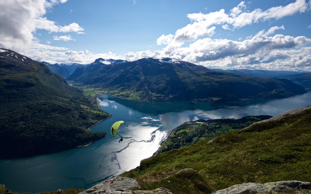
Fjords are often considered some of the most picturesque natural landscapes in the world for several reasons:
-
Dramatic Geological Features: Fjords are characterized by their steep, towering cliffs or mountains that rise abruptly from the water's edge. These striking geological features create a breathtaking visual contrast between the vertical rock faces and the deep, calm waters of the fjord.
-
Crystal-Clear Waters: Fjords typically have crystal-clear, blue-green waters that can be incredibly inviting and mesmerizing. The clarity of the water allows you to see deep into the fjord, revealing the underwater world and adding to the overall beauty of the landscape
- Biodiversity: Fjords are often teeming with biodiversity. They provide important habitats for various marine species, and you can often spot wildlife such as seals, seabirds, and sometimes even whales in and around fjords. The presence of diverse life forms adds to the charm of these landscapes
- Waterfalls: Many fjords are adorned with cascading waterfalls that tumble down from the cliffs above into the fjord's waters. These waterfalls create a dynamic and picturesque element, adding movement and sound to the scene
|
Previous Year Questions
1. How are fjords formed? Why do they constitute some of the most picturesque of the world (UPSC CSE Mains GS1 2023)
|
PTERYGOTRIGLA INTERMEDICA

- The new species, commonly known as gurnards or sea-robins, belongs to the family Triglidae. Named Pterygotrigla intermedica, it has characters quite similar to species like Pterygotrigla hemisticta
- It is the fourth species of Pterygotrigla genus reported in India so far, he said, and there are a total 178 species of the Triglidae family worldwide
- The specimens of this fish were found to be very distinct from other gurnad species in various aspects such as snout length, shape of the internuchal space and size of the cleithral spine
- A distinct pectoral-fin with black membranes on the inner surface, white posterior margin and three small white spots basally in fin, each ray creamy white on the new species
- It had a combination of characters like a long opercular spine and a very short cleithral spine; lateral-line,gill rakers on upper limb and 12–13 on lower limb of first gill arch and a large black blotch between the 4th and 6th spines of the first dorsal fin
- The Zoological Survey of India (ZSI) is the premier Indian organization in zoological research and studies to promote the survey, exploration and research of the fauna in the country.
- It was founded on 1 July 1916 by the Ministry of Environment, Forest and Climate Change of the Government of India.
- The ZSI has its genesis in the Zoological Section of the Indian Museum, which was established in 1875.
- By gradually strengthening its staff and expanding its research program, the Survey has grown into a leading institution in zoological research and education.
- The ZSI is headquartered in Kolkata and has 16 regional centers spread across the country. It has a staff of over 300 scientists and technical personnel.
- The ZSI's mission is to conduct surveys, exploration and research on the fauna of India, and to disseminate the knowledge gained to the scientific community, government agencies, and the general public
|
Previous Year Questions 1.Recently, our scientists have discovered a new and distinct species of banana plant which attains a height of about 11 meters and has orange coloured fruit pulp. In which part of India has it been discovered? (UPSC CSE 2016) (a) Andaman Islands Answer: (a) |
PACIFIC ISLAND NATIONS SUMMIT
1. Context
2. About the Pacific Island Nations Summit
- The Pacific Island Nations Summit is a meeting of leaders from the Pacific Islands Forum (PIF), a regional organization that was established in 1971 to promote cooperation among Pacific island countries.
- The PIF has 18 member states, including Australia, Fiji, Kiribati, New Zealand, Papua New Guinea, Samoa, Solomon Islands, Tonga, and Tuvalu.
- It is an important forum for Pacific Island leaders to share their views on a wide range of issues, including, Climate change, Economic development, Maritime security, Sustainable development and Trade and investment.
- The first Pacific Island Nations Summit was held in September 2022 in Washington, D.C., hosted by President Joe Biden.
- The summit was held to discuss a range of issues, including climate change, economic development, maritime security, and regional cooperation.
- The Pacific Island Nations Summit is an important forum for Pacific Island leaders to discuss their shared challenges and develop strategies for cooperation.
- The summit is also an opportunity for Pacific island leaders to engage with the United States and other international partners on issues of importance to their region.

3. Importance of Pacific Islands
The Pacific Islands are important for a variety of reasons, and their significance extends beyond their idyllic landscapes and vibrant cultures. Here are several key reasons why the Pacific Islands are important
Biodiversity: The Pacific Islands are home to unique and diverse ecosystems, both on land and in the surrounding oceans. These islands host a wide range of plant and animal species, many of which are found nowhere else on Earth. Preserving this biodiversity is essential for global ecological balance.
Ocean Resources: The Pacific Ocean is the largest and deepest ocean in the world. The islands in the Pacific are strategically located near rich fishing grounds, making them crucial for the global fishing industry. Additionally, the ocean offers mineral resources, including rare earth elements, which are essential for modern technology.
Maritime Trade Routes: The Pacific Ocean serves as a vital transportation route for global trade. It connects the economies of Asia, the Americas, and Oceania. Many of the Pacific Islands are strategically located along these major shipping routes, making them important hubs for international commerce.
Climate Change and Sea-Level Rise: Pacific Island Nations are among the most vulnerable to the impacts of climate change, including rising sea levels, extreme weather events, and ocean acidification. Their experiences and voices are critical in shaping global climate policies and raising awareness about climate change's disproportionate effects on small island states.
Cultural and Indigenous Heritage: The Pacific Islands are rich in cultural diversity, with numerous indigenous languages, traditions, and art forms. Preserving and respecting these cultures is not only important for the people of the islands but also contributes to global cultural diversity and heritage.
Tourism and Economy: Tourism is a significant economic driver for many Pacific Island Nations. Their stunning natural beauty, tropical climates, and cultural attractions attract visitors from around the world. Tourism revenues play a crucial role in supporting local economies.
Regional Security: The Pacific Islands region is strategically important for global security. Several countries, including the United States, have military bases and alliances in the region. Additionally, the Pacific Islands have been central to discussions on regional security, particularly regarding territorial disputes and the South China Sea.
Global Health and Disease Monitoring: The Pacific Islands are important for monitoring and researching diseases like Zika and dengue fever due to their location and climate. Their participation in global health efforts helps track and prevent the spread of infectious diseases.
International Diplomacy: Pacific Island Nations often play a significant role in international diplomacy and global forums, especially when it comes to issues like climate change, sustainable development, and human rights.
Research and Exploration: Researchers are drawn to the Pacific Islands to study diverse subjects, including marine biology, geology, and anthropology. These islands offer valuable insights into the Earth's natural history and human evolution.
4. India’s relationship with Pacific island nations
India's relationship with Pacific Island nations has evolved over the years and is characterized by a mix of diplomatic, economic, and cultural engagements. While India is not a Pacific nation geographically, it has been actively pursuing partnerships with countries in the region. Here are some key aspects of India's relationship with Pacific Island nations:
Diplomatic Engagements: India has been increasing its diplomatic outreach to Pacific Island countries, recognizing their strategic significance and their growing role in international forums. India has established diplomatic missions or embassies in several Pacific Island nations, including Fiji, Papua New Guinea, and Samoa.
Bilateral Cooperation: India has initiated bilateral cooperation programs with various Pacific Island nations in areas such as capacity building, development assistance, and healthcare. These programs aim to enhance economic and social development in the region.
Development Assistance: India provides development assistance to Pacific Island countries, including grants and soft loans for infrastructure development projects. This assistance covers a range of sectors, including renewable energy, information technology, and education.
Trade and Economic Relations: India has sought to expand trade and economic relations with Pacific Island nations. While the volume of trade is relatively small, India has expressed interest in increasing trade ties, particularly in sectors like agriculture, fisheries, and pharmaceuticals.
Cultural Ties: India has cultural ties with many Pacific Island countries due to the Indian diaspora living in these nations. Cultural exchanges, festivals, and educational scholarships have helped strengthen these ties.
Multilateral Engagement: India participates in regional and international forums where Pacific Island nations are represented. These include the Pacific Islands Forum (PIF), the United Nations, and various climate change and environmental agreements. India often collaborates with Pacific Island nations on issues related to climate change, disaster management, and sustainable development.
Security Cooperation: While not a primary focus, India has engaged in limited security cooperation with some Pacific Island nations. This includes maritime security initiatives and capacity-building efforts.
Regional Connectivity: India has shown interest in improving regional connectivity with the Pacific Islands. Initiatives such as the "Forum for India-Pacific Islands Cooperation (FIPIC)" and the International Solar Alliance (ISA) have aimed to foster greater regional cooperation.
Diaspora: India's diaspora in Pacific Island nations, particularly in Fiji, plays a significant role in cultural exchange and economic activities. They maintain cultural traditions and contribute to the local economies.
COVID-19 Assistance: During the COVID-19 pandemic, India provided medical supplies and assistance to several Pacific Island countries as part of its humanitarian outreach.
5. The Way Forward
- India's engagement with Pacific Island nations should continue to be multifaceted, with a focus on diplomatic collaboration, economic partnerships, and regional cooperation.
- By actively addressing shared challenges and leveraging opportunities, India can further deepen its relationship with the Pacific Island nations for mutual benefit and regional stability.
|
For Prelims: Pacific Islands Forum, climate change, COVID-19 pandemic, rising sea levels, Forum for India-Pacific Islands Cooperation, International Solar Alliance,
For Mains:
1. Analyze the potential for India to enhance its trade relations with Pacific Island nations, including the challenges and opportunities in expanding economic ties. (250 Words)
2. Discuss the significance of the Pacific Islands in the context of global biodiversity and its implications for ecological balance. (250 Words)
|
|
Previous Year Questions
1. The first summit of the Forum for India-Pacific Islands Cooperation (FIPIC) was held in: (CDS GK 2016)
A. Jaipur B. Suva C. New Delhi D. Port Moresby
Answer: B
2. The Ministry of Environment, Forest and Climate Change recently published the draft Environment Impact Assessment (EIA) Notification, in 2020. Which of the following statements is correct about EIA? (Punjab Civil Service 2020)
1. It predicts the effect of a proposed industrial/infrastructural project on the environment.
2. It prevents the proposed activity/project from being approved without proper oversight or taking adverse consequences into account.
3. It compares various alternatives for a project and seeks to identify the one which represents the best combination of economic and environmental costs and benefits.
4. As per the new notification, Coal and non-Coal mineral prospecting and solar photovoltaic projects do not need prior environmental clearance.
Select the correct answer using the code given below:
A. Only 1 and 2
B. Only 2, 3 and 4
C. Only 1, 2 and 3
D. Only 1, 2 and 4
Answer: D
3. In the context of vaccines manufactured to prevent COVID-19 pandemic, consider the following statements: (UPSC CSE 2022)
1. The Serum Institute of India produced COVID-19 vaccine named Covishield using mRNA platform.
2. Sputnik V vaccine is manufactured using vector based platform.
3. COVAXIN is an inactivated pathogen based vaccine.
Which of the statements given above are correct?
A. 1 and 2 only B. 2 and 3 only C. 1 and 3 only D. 1, 2 and 3
Answer: B
4. Consider the following statements: (UPSC CSE 2016)
1. The International Solar Alliance was launched at the United Nations Climate Change Conference in 2015.
2. The Alliance includes all the member countries of the United Nations.
Which of the statements given above is/are correct?
A. 1 only B. 2 only C. Both 1 and 2 D. Neither 1 nor 2
Answer: A
|
CAPACITY BUILDING INITIATIVE FOR TRANSPARENCY (CBIT)
- The Capacity-building Initiative for Transparency (CBIT) is a program established under the United Nations Framework Convention on Climate Change (UNFCCC) to support developing countries in enhancing their capacity to meet their reporting and transparency requirements related to climate action.
- CBIT was created as part of the Paris Agreement, which was adopted in 2015 and aims to combat climate change by limiting global warming to well below 2 degrees Celsius above pre-industrial levels.
- CBIT focuses on helping developing countries strengthen their institutional and technical capabilities to accurately measure, report, and verify their greenhouse gas emissions and the progress they are making in implementing climate mitigation and adaptation activities. This transparency is crucial for tracking global progress toward achieving the climate goals set out in the Paris Agreement.
3. COP 21
COP 21 decided that the aim of CBIT is to:
- Strengthen national institutions for transparency-related activities in line with national priorities;
- Provide relevant tools, training and assistance for meeting the provisions stipulated in Article 13 of the Agreement; and
- Assist in the improvement of transparency over time.
Transparency is a fundamental principle within the Paris Agreement, which was adopted in 2015 as a landmark international treaty to address climate change. The Agreement recognizes the importance of transparency in several key aspects:
-
Transparency of Action: Under the Paris Agreement, countries that are Parties to the Agreement (referred to as Parties) are required to regularly communicate their efforts to mitigate greenhouse gas emissions (referred to as "nationally determined contributions" or NDCs) and adapt to the impacts of climate change. This includes providing information on their emission reduction targets, policies, and measures taken to achieve these targets. This transparency enables other Parties and stakeholders to assess the adequacy and effectiveness of a country's climate actions.
-
Transparency of Support: Developed countries, often referred to as Annex II Parties, have an obligation to provide financial resources, technology transfer, and capacity-building support to developing countries to help them cope with climate change. Transparency in financial flows and support is crucial to ensure that these commitments are being met and that the support is reaching those who need it most.
-
Transparency of Information Sharing: The Paris Agreement establishes a framework for the transparent sharing of information, data, and best practices related to climate change. This information sharing helps Parties learn from each other's experiences and promote cooperation and mutual assistance in tackling climate change.
-
Transparency Framework: The Agreement includes provisions for the development of a "enhanced transparency framework." This framework sets out the rules and procedures for reporting and reviewing the climate-related information that Parties provide. It ensures that the information exchanged is consistent, comparable, and reliable. The enhanced transparency framework is designed to be more robust and comprehensive than the transparency arrangements under the previous Kyoto Protocol.
-
Review and Accountability: The Paris Agreement includes a process for the regular review of Parties' progress in implementing their climate actions. This process, often referred to as the "global stocktake," is conducted every five years to assess collective progress toward the Agreement's goals. Transparency is crucial in this context, as it allows for an objective assessment of each Party's efforts.
Here's how the GEF contributes to CBIT:
-
Financial Support: One of the primary roles of the GEF in the CBIT is to provide financial resources to support capacity-building activities related to transparency. This includes funding for training programs, workshops, technical assistance, and the development of necessary infrastructure and systems to improve a country's ability to measure, report, and verify its greenhouse gas emissions and climate actions accurately.
-
Project Implementation: The GEF, through its implementing agencies such as the United Nations Development Programme (UNDP) and the United Nations Environment Programme (UNEP), assists developing countries in designing and implementing CBIT projects. These projects aim to enhance national capacity for transparency in line with the Paris Agreement's requirements.
-
Technical Assistance: The GEF supports countries in accessing technical expertise and knowledge to strengthen their institutional and technical capabilities. This includes assistance in developing or improving national greenhouse gas inventories, data management systems, and the legal and regulatory frameworks needed for transparency.
-
Promotion of Best Practices: The GEF helps disseminate best practices and lessons learned from CBIT projects across different countries. This knowledge sharing is crucial for countries to learn from each other's experiences and to adopt effective approaches to transparency-related activities.
-
Facilitating Collaboration: The GEF facilitates collaboration among various stakeholders, including governments, non-governmental organizations (NGOs), and international agencies, to ensure a coordinated and integrated approach to CBIT implementation. Collaboration helps avoid duplication of efforts and maximizes the impact of capacity-building activities.
-
Reporting and Accountability: As part of its commitment to transparency and accountability, the GEF reports on its financial contributions to CBIT and the outcomes achieved through its support. This reporting helps donors, countries, and other stakeholders track progress and assess the effectiveness of CBIT projects.
-
Integration with Climate Finance: The GEF's support for CBIT aligns with broader climate finance efforts. It ensures that capacity-building for transparency is integrated into the larger framework of climate finance, which includes both public and private sources of funding.
|
For Prelims: Paris Agreement, Sustainable Development Goals (SDGs)
For Mains: 1."The Sustainable Development Goals (SDGs) provide a comprehensive and integrated framework for addressing global challenges." Discuss the relevance and significance of SDGs in the context of India's development agenda. What are the key challenges in achieving these goals in the Indian context?
2.The Paris Agreement aims to limit global warming to well below 2 degrees Celsius above pre-industrial levels. Discuss the key provisions of the Paris Agreement and the significance of this temperature target. Analyze the role of India in achieving the Agreement's objectives
|
|
Previous Year Questions
1.The 'Paris Agreement' adopted in Conference of the Parties (COP 21) in December 2015 will be effective provided the document is signed by: (UPSC CAPF 2016)
A.51 UNFCCC parties accounting for at least 51% of global greenhouse gas emission
B.51 UNFCCC parties accounting for at least 55% of global greenhouse gas emission
C.55 UNFCCC parties accounting for at least 55% of global greenhouse gas emission
D. 75 UNFCCC parties accounting for at least 51% of global greeenhouse gas emission
Answer (C)
|
SOUTH CHINA SEA
1. Context
2. China's South China Sea Escalation
- Amid the global pandemic, China is intensifying its presence in the South China Sea, particularly focusing on the disputed Spratly Islands and Paracel Islands.
- This move has raised concerns among neighbouring countries, such as Vietnam and the Philippines, who also claim sovereignty over these territories.
- China has unilaterally renamed 80 islands and geographical features in the South China Sea, a controversial action that has drawn criticism from neighbouring nations.
- This renaming effort exacerbates the ongoing territorial dispute and has the potential to strain diplomatic relations in the Asia-Pacific region.
- The Spratly Islands dispute involves China, Taiwan, Vietnam, the Philippines, and Malaysia, all vying for control over this archipelago and its surrounding features.
- Although these islands are largely uninhabited, they are believed to harbour significant untapped natural resources.
- However, due to the dispute, exploration and resource assessment efforts remain limited.
3. Historical Background
- The discovery of oil near the Palawan coast in the 1970s further fueled territorial claims, even though some reports suggest limited oil and gas reserves in the region.
- This historical context underscores the complexity of the Spratly Islands dispute.
- The Paracel Islands dispute is equally complex, with China and Vietnam both laying historical claims to this archipelago.
- Historical texts from various periods, including colonial-era records, have been cited to support these conflicting claims.
- Tensions escalated in 1974 when China took control of the islands, sparking a prolonged dispute involving Vietnam and, later, Taiwan.
 Image Source: Forbes
4. Contemporary Developments
- Since 2012, China, Taiwan, and Vietnam have pursued various strategies to bolster their territorial claims, including constructing government buildings, promoting tourism, reclaiming land, and expanding military presence on these islands.
- China's recent establishment of new administrative districts in both the Spratly and Paracel Islands prompted the Chinese government to rename numerous geographical features.
- This move is reminiscent of a similar initiative in 1983 when China renamed 287 features in the disputed region.
- China's increased military activity and the creation of artificial islands for military and economic purposes in the South China Sea have raised concerns among neighbouring countries and Western powers.
- Recent incidents, such as the sinking of a Vietnamese fishing trawler near the Paracel Islands and the construction of Chinese research stations on disputed Philippine territory, have further inflamed tensions.
5. Conclusion
- The South China Sea remains a highly volatile region, with the potential for further diplomatic tensions and military escalations.
- The ongoing territorial disputes, fueled by historical claims and concerns over natural resources, pose a significant challenge to stability in the Asia-Pacific region and require careful diplomatic efforts to find peaceful resolutions.
|
For Prelims: South China Sea, Paracel Islands, Spratly Islands,
For Mains:
1. Discuss the historical background of the territorial disputes in the South China Sea. How have historical claims contributed to the complexity of the issue? (250 Words)
|
|
Previous Year Questions
1. The South China Sea Dispute involves which of the following countries? (CDS GK 2019)
1. China
2. Vietnam
3. Malaysia
4. Indonesia
Select the correct answer using the code given below.
A. 1 and 4 B. 1 and 2 only C. 1, 2 and 3 D. 2, 3 and 4
Answer: C
2. Which one of the following statements best reflects the issue with Senkaku Islands, sometimes mentioned in the news? (UPSC CSE 2022)
A. It is generally believed that they are artificial islands made by a country around South China Sea.
B. China and Japan engage in maritime disputes over these islands in East China Sea.
C. A permanent American military base has been set up there to help Taiwan to increase its defence capabilities.
D. Though International Court of Justice declared them as no man's land, some South-East Asian countries claim them.
Answer: B
|
LONG PERIOD AVERAGE (LPA)
Rainfall in the four-month June-September southwest monsoon season was in the normal range in 2019, 2020, and 2021 as well
2. About Long Period Average (LPA)
- The IMD predicts a “normal”, “below normal”, or “above normal” monsoon in relation to a benchmark “long period average” (LPA)
- According to the IMD, the “LPA of rainfall is the rainfall recorded over a particular region for a given interval (like month or season) average over a long period like 30 years, 50 years, etc”
- The IMD’s prediction of a normal monsoon on Thursday was based on the LPA of the 1971-2020 period, during which India received 87 cm of rain for the entire country on average
- The IMD has in the past calculated the LPA at 88 cm for the 1961-2010 period, and at 89 cm for the period 1951-2000
- While this quantitative benchmark refers to the average rainfall recorded from June to September for the entire country, the amount of rain that falls every year varies from region to region and from month to month
- Therefore, along with the countrywide figure, the IMD also maintains LPAs for every meteorological region of the country this number ranges from around 61 cm for the drier Northwest India to more than 143 cm for the wetter East and Northeast India
- LPA of the southwest monsoon rainfall over Kerala: 556 mm, 659 mm, 427 mm and 252 mm for the months of June, July, August, and September respectively
- Broken down monthwise for the entire country, the LPA figures for the season are 16.36 cm for June, 28.92 cm for July, 26.13 cm for August, and 17.34 cm for September
3. Need of LPA
- The IMD records rainfall data at more than 2,400 locations and 3,500 rain-gauge stations
- Because annual rainfall can vary greatly not just from region to region and from month to month, but also from year to year within a particular region or month, an LPA is needed to smooth out trends so that a reasonably accurate prediction can be made
- A 50-year LPA covers for large variations in either direction caused by freak years of unusually high or low rainfall (as a result of events such as El Nino or La Nina)
- As well as for the periodic drought years and the increasingly common extreme weather events caused by climate change
4.IMD Calculations
Quantitatively, the monsoon seasonal (June to September) rainfall is likely to be 99% of the LPA with a model error of ± 5%. The LPA of the season rainfall over the country as a whole for the period 1971-2020 is 87 cm
The IMD maintains five rainfall distribution categories on an all-India scale. These are:
- Normal or near normal, when the percentage departure of actual rainfall is +/-10% of LPA, that is, between 96-104% of LPA
- Below normal, when departure of actual rainfall is less than 10% of LPA, that is 90-96% of LPA
- Above normal, when actual rainfall is 104-110% of LPA
- Deficient, when departure of actual rainfall is less than 90% of LPA
- Excess, when the departure of actual rainfall is more than 110% of LPA
- The beginnings of meteorology in India can be traced to ancient times. Early philosophical writings of the 3000 B.C. era, such as the Upanishadas, contain serious discussion about the processes of cloud formation and rain and the seasonal cycles caused by the movement of earth round the sun
- Varahamihira's classical work, the Brihatsamhita, written around 500 A.D., provides a clear evidence that a deep knowledge of atmospheric processes existed even in those times
- It was understood that rains come from the sun (Adityat Jayate Vrishti) and that good rainfall in the rainy season was the key to bountiful agriculture and food for the people
- Kautilya's Arthashastra contains records of scientific measurements of rainfall and its application to the country's revenue and relief work. Kalidasa in his epic, 'Meghdoot', written around the seventh century, even mentions the date of onset of the monsoon over central India and traces the path of the monsoon clouds
- Meteorology, as we perceive it now, may be said to have had its firm scientific foundation in the 17th century after the invention of the thermometer and the barometer and the formulation of laws governing the behaviour of atmospheric gases
- It was in 1636 that Halley, a British scientist, published his treatise on the Indian summer monsoon, which he attributed to a seasonal reversal of winds due to the differential heating of the Asian land mass and the Indian Ocean
- India is fortunate to have some of the oldest meteorological observatories of the world. The British East India Company established several such stations, for example, those at Calcutta in 1785 and Madras (now Chennai) in 1796 for studying the weather and climate of India
- The Asiatic Society of Bengal founded in 1784 at Calcutta, and in 1804 at Bombay (now Mumbai), promoted scientific studies in meteorology in India
- A disastrous tropical cyclone struck Calcutta in 1864 and this was followed by failures of the monsoon rains in 1866 and 1871
- In the year 1875, the Government of India established the India Meteorological Department, bringing all meteorological work in the country under a central authority
- The first Director General of Observatories was Sir John Eliot who was appointed in May 1889 at Calcutta headquarters
- The headquarters of IMD were later shifted to Shimla, then to Poona (now Pune) and finally to New Delhi
- From a modest beginning in 1875, IMD has progressively expanded its infrastructure for meteorological observations, communications, forecasting and weather services and it has achieved a parallel scientific growth
- IMD has always used contemporary technology. In the telegraph age, it made extensive use of weather telegrams for collecting observational data and sending warnings
- Later IMD became the first organisation in India to have a message-switching computer for supporting its global data exchange.
- One of the first few electronic computers introduced in the country was provided to IMD for scientific applications in meteorology
- India was the first developing country in the world to have its own geostationary satellite, INSAT, for continuous weather monitoring of this part of the globe and particularly for cyclone warning
- IMD has continuously ventured into new areas of application and service and steadily built upon its infrastructure in its history of 140 years
- It has simultaneously nurtured the growth of meteorology and atmospheric science in India. Today, meteorology in India is poised at the threshold of an exciting future
|
For Prelims: IMD, Long Period Average, El Nino, La Nino
For Mains: 1.What characteristics can be assigned to monsoon climate that succeeds in feeding more than 50 percent of the won population residing in Monsoon Asia? (UPSC GS 1 2017
|
|
Previous Year Questions:
1.La Nina is suspected to have caused recent floods in Australia. How is La Nina different from El Nino? (UPSC 2011 )
A. 1 only
B. 2 only
C. Both 1 and 2
D. Neither 1 nor 2
Answer (D)
2.The seasonal reversal of winds is the typical characteristic of (UPSC 2014 )
A. Equatorial climate
B. Mediterranean climate
C. Monsoon climate
D. All of the above climates
Answer (C)
3.With reference to ‘Indian Ocean Dipole (IOD)’ sometimes mentioned in the news while forecasting Indian monsoon, which of the following statements is/are correct? (2017 Prelims)
A. 1 only
B. 2 only
C. Both 1 and 2
D. Neither 1 nor 2
Answer (B)
4.Consider the following statements: (2015)
A. 1 only
B. 2 only
C. Both 1 and 2
D. Neither 1 nor 2
Answer (B)
|


