BIMARU
1. Context
2. What is BIMARU?
- BIMARU is an acronym that refers to a group of states in India with certain socio-economic and demographic characteristics.
- The term was coined by demographer Ashish Bose in the mid-1980s and stands for Bihar, Madhya Pradesh, Rajasthan, and Uttar Pradesh.
- These states were collectively labeled as BIMARU due to their relatively lower development indicators and challenges in areas such as population growth, healthcare, education, and economic progress.
- The term was used to highlight the specific issues and disparities faced by these states compared to other regions in India.
.png)
3. Key points about BIMARU:
- Origin: The term BIMARU was coined by Ashish Bose while briefing then-Prime Minister Rajiv Gandhi in 1985. At that time, the states of Jharkhand, Chhattisgarh, and Uttarakhand were not separate entities but were included in the original grouping.
- Significance: BIMARU states were characterized by a range of challenges, including high population growth rates, lower literacy rates, inadequate healthcare infrastructure, and overall lower socio-economic development.
- Population Growth: One of the central concerns of BIMARU states was their high population growth rates. These states contributed significantly to India's total population and posed challenges to family planning and population control efforts.
- Development Indicators: BIMARU states exhibited lower development indicators such as lower literacy rates, higher infant mortality rates, and limited access to quality healthcare and education. These indicators were significantly below the national average.
- Political Implications: The population distribution of BIMARU states played a role in the allocation of seats in the Indian Parliament. The seats were allocated based on the population as per the 1971 census and remained frozen until 2001 (extended to 2026) to give states time to improve their family planning efforts.
- Criticism and Changes: The term BIMARU has faced criticism for its negative connotation, which some find stigmatizing. Additionally, with the creation of new states like Jharkhand, Chhattisgarh, and Uttarakhand, the composition of the group has changed over time.
- Population Trends: Despite facing challenges, there have been efforts to improve the development indicators in BIMARU states. Some of these states have made progress in reducing population growth rates and improving socio-economic conditions.
- Policy and Development: Over the years, various policies and development initiatives have been implemented to address the challenges faced by these states. These efforts have aimed to improve healthcare, education, infrastructure, and overall economic conditions.
- Regional Disparities: BIMARU highlighted the disparities in development and socio-economic conditions across different states and regions in India. It underscored the need for targeted efforts to address the specific challenges faced by different regions.
- Evolving Landscape: As India's development landscape evolves, the focus has shifted from merely labeling states to understanding the nuances of development challenges and implementing tailored solutions to address them.
4. Role of BIMARU states in population growth
- Former BIMARU states made up 41% of India's population in 2001, projected to be 43.5% in 2026.
- Implications for political representation and population increase distribution.
- BIMARU (excluding new states) contributed 49.1% of India's population growth from 2011 to 2036.
- Population impacts delimitation process, seats in Parliament.
- Division of seats based on the 1971 census, frozen until 2001 (extended to 2026) for family planning efforts.
- Southern states find seat division unfair due to successful family planning efforts.
- Tamil Nadu is cited as an example of effective family planning implementation.
- BIMARU states exhibit lower indicators: women's literacy, and institutional childbirth rates.
- Population growth rate dip in BIMARU states: 24.99% (1991-2001) to 20.92% (2001-11), impacting national growth rate.
5. Alternatives to BIMARU
- Odisha was occasionally included in the BIMARU grouping, forming BIMARU.
- Despite the smaller population, Odisha's development challenges are noted.
- Empowered Action Group (EAG) was formed in 2001 to address issues in these states.
- Shailaja Chandra, former Delhi Chief Secretary, and National Population Stabilisation Fund Executive Director, mentioned in OECD article.
- National Rural Health Mission, India's largest health program, allocated resources to high-focus states in EAG, including BIMAROU states.
|
For Prelims: BIMARU, Empowered Action Group (EAG), Prime Minister Rajiv Gandhi.
For Mains: 1. Explain the concept of BIMARU states in India. Discuss the socioeconomic and demographic challenges that had led to the coining of this term. (250 words).
|
MULTIDIMENSIONAL POVERTY INDEX (MPI)
-
Health: This dimension includes indicators such as child mortality and nutrition. It measures whether households have access to proper healthcare and nutrition, ensuring the physical well-being of individuals.
-
Education: Education-related indicators like years of schooling and school attendance are considered in this dimension. It evaluates whether individuals have access to quality education and opportunities for human capital development.
-
Standard of Living: This dimension assesses living conditions by looking at indicators like access to clean water, sanitation, cooking fuel, electricity, and housing quality. It reflects the overall living environment of individuals and households.
Malnutrition in children can manifest in four different ways:
- Wasting: This is when a child's weight-for-height is below the standard for their age. It is a sign of acute undernutrition, and it can be caused by a recent illness or a lack of food.
- Stunting: This is when a child's height-for-age is below the standard for their age. It is a sign of chronic undernutrition, and it can be caused by a long-term lack of food or by repeated infections
The ICDS Scheme provides a package of six services to children under the age of 6 years:
- Supplementary feeding: Children are provided with a hot meal every day.
- Immunization: Children are vaccinated against common childhood diseases.
- Health check-up: Children are screened for malnutrition and other health problems.
- Referral services: Children with serious health problems are referred to hospitals for treatment.
- Non-formal education: Children are provided with non-formal education.
- Early childhood care: Children are provided with a safe and stimulating environment to learn and grow
|
For Prelims: Malnutrition, Stunting Multidimensional Poverty Index, NITI Aayog
For Mains: 1.Malnutrition remains a persistent challenge in many developing countries, including India. Analyze the causes and consequences of malnutrition, and discuss the policy measures and strategies that can effectively address this issue
2.Malnutrition affects various segments of the population, from children to adults. Discuss the specific causes and consequences of child malnutrition, and evaluate the impact of early childhood nutrition interventions in breaking the cycle of intergenerational malnutrition
|
|
Previous year Questions
1.Which of the following are the Objectives of 'National Nutrition Mission'? (UPSC CSE 2017)
1. To Create Awareness relating to malnutrition among pregnant women and lactating mothers
2. To reduce the incidence of anaemia among young children, adolscent girls, and women
3.To promote the Consumption of millets, coarse cereals, and unpolished rice
4. To promote the consumption of poultry eggs
Select the correct answer using the code given below
A. 1 and 2 Only
B.1, 2 and 3
C. 1, 2 and 4
D. 3 and 4
Answer (A)
|
CAUVERY WATER DISPUTE
- The Cauvery water dispute, which has been a bone of contention between Karnataka and Tamil Nadu for decades now
- The Cauvery water dispute has influenced the politics of the region for long with parties stirring the emotions of people as the river has a deep cultural, economic and religious significance for them
- The Cauvery basin covers a large expanse of land including major chunks in Karnataka and Tamil Nadu and also smaller areas in Kerala and Puducherry
- Initially, the dispute was between Karnataka and TN but later Kerala and Puducherry also entered the fray
- The issue dates back to 1892 when an agreement was filed between Madras Presidency and Mysore for arbitration but led to a fresh set of disputes
- Later, attempts were renewed to arbitrate between the two states under supervision of the Government of India and a second agreement was signed in 1924
- As Kerala and Puducherry also laid claim on share of Cauvery water after India attained Independence, a Fact Finding Committee was set-up in 1970 to figure out the situation on ground
- The committee submitted its report in 1972 and further studies were done by expert committee and the states reached at an agreement in 1976
- However, after a new government came to power in Tamil Nadu, it refused to give a consent to terms of agreement paving way for further dispute
- Later in 1986, Tamil Nadu government appealed the Central government to constitute a tribunal for solving the issue under Inter-State Water Disputes Act, 1956
- However, the tribunal was not set-up until Supreme Court took cognizance of the matter and ordered the Central government to do so in 1990. The Cauvery Waters Tribunal was constituted on June, 2, 1990
- After 16 years of hearing and an interim order, the Tribunal announced its final order in 2007 allocating 419 tmc ft water to Tamil Nadu and 270 tmc ft to Karnataka
- Kerala was given 30 tmc ft and Puducherry got 7 tmc ft. The Tribunal had come to a conclusion that total availability of water in Cauvery basin stood at 740 tmc ft
- However, both Tamil Nadu and Karnataka filed a review petition before the Tribunal
- In 2012, Prime Minister Manmohan Singh, as chairman of Cauvery River Authority, directed the Karnataka government to release 9,000 cusecs of water daily
- The Cauvery River, also spelled as Kaveri, is one of the major rivers in South India. It originates from the Western Ghats in Karnataka and flows through the states of Karnataka and Tamil Nadu before emptying into the Bay of Bengal.
- The river and its tributaries have significant cultural, historical, and ecological importance.
- The Cauvery River originates at Talakaveri in the Brahmagiri hills of the Western Ghats in Karnataka.
- It flows eastward through Karnataka and Tamil Nadu before eventually emptying into the Bay of Bengal.
- The river traverses a distance of approximately 765 kilometers

- The Cauvery Water Management Authority (CWMA) is a statutory body constituted by the Government of India under the Inter-State River Water Disputes Act, 1956.
- The CWMA is responsible for the implementation of the Cauvery Water Disputes Tribunal (CWDT) Award, as modified by the Supreme Court of India
- The CWMA has its headquarters in New Delhi. It has a governing council, which is headed by the Union Minister for Water Resources. The governing council also has representatives from the states of Karnataka, Tamil Nadu, Kerala, and Puducherry.
- The CWMA is a critical institution for the management of the Cauvery River basin. It is responsible for ensuring that the river's water is shared in a fair and equitable way, and that the river is managed in a sustainable manner.
|
For Prelims: Cauvery river, Tributaries, CWMA
For Mains: 1.The Cauvery River water dispute between Karnataka and Tamil Nadu has been a recurring issue. Discuss the historical background, key points of contention, and the legal and political measures taken to address this interstate water dispute
2.The Cauvery basin has played a significant role in the agricultural economies of Karnataka and Tamil Nadu. Examine the challenges and opportunities associated with the irrigation practices and water management strategies in the region
|
|
Previous Year Questions
1.Which of the following Protected Areas are located in Cauvery basin? (UPSC GS1, 2020)
1. Nagarhole National Park 2. Papikonda National Park 3. Sathyamangalam Tiger Reserve 4. Wayanad Wildlife Sanctuary Select the correct answer using the code given below: (a) 1 and 2 only (b) 3 and 4 only (c) 1, 3 and 4 only (d) 1, 2, 3 and 4 Answer (c)
|
ASHOKAN DHAMMA
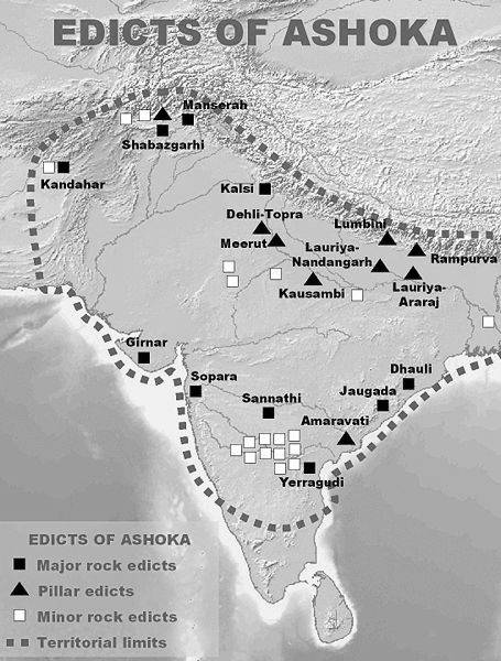
The Edicts of Ashoka are divided into following categories:
- Major Rock Edicts: There are 14 Major Rock Edicts, which are inscribed on large rocks. These edicts are located throughout the Mauryan Empire, from present-day Afghanistan to Bangladesh.
- Minor Rock Edicts: There are 7 Minor Rock Edicts, which are inscribed on smaller rocks. These edicts are located in the heartland of the Mauryan Empire, in modern-day Bihar and Uttar Pradesh
- Pillar Edicts: There are 6 Pillar Edicts, which are inscribed on pillars. These pillars are located throughout the Mauryan Empire, and some of them are decorated with sculptures of animals.
- Cave Edicts: There are 2 Cave Edicts, which are inscribed on the walls of caves. These caves are located in the Barabar and Nagarjunakonda hills in India.
- Greek and Aramaic Edicts: There are 3 Greek and Aramaic Edicts, which are inscribed in Greek and Aramaic, respectively. These edicts are located in Kandahar, Afghanistan
3.Topics covered in the edicts of Ashoka
The Edicts of Ashoka cover a wide range of topics, including:
- The importance of dhamma (righteousness)
- The need for non-violence and compassion
- The importance of education and welfare
- The need to respect all living beings
- The importance of spreading Buddhism
Court art and popular art are two broad categories of art that can be distinguished by their intended audience, their subject matter, and their style.
- Court art is created for the elite, usually by royal or aristocratic patrons. It is often commissioned to celebrate the power and prestige of the patron, and it may be used to promote a particular ideology or message. Court art is typically characterized by its high quality, its use of expensive materials, and its complex symbolism.
- Popular art is created for the masses, usually by anonymous artists. It is often concerned with everyday life and the experiences of ordinary people. Popular art is typically characterized by its simplicity, its use of everyday materials, and its direct appeal to the emotions.
Here is a table that summarizes the key differences between court art and popular art:
| Characteristic | Court Art | Popular Art |
|---|---|---|
| Intended audience | Elite | Masses |
| Subject matter | Power, prestige, ideology | Everyday life, ordinary people |
| Style | High quality, complex symbolism | Simple, direct appeal to emotions |
| Materials | Expensive | Everyday |
| Patronage | Royal or aristocratic | Anonymous artists |
- According to Historians, the principles of Dhamma were so formulated as to be acceptable to people belonging to different communities and following any religious sect
- Dhamma was not given any formal definition or structure, It emphasised toleration and general behaviour
- Dhamma stressed dual toleration-it emphasised on toleration of people themselves and also the toleration of their various beliefs and ideas
- There is a stress on the notion of showing consideration towards slaves and servants; there is stress also on obedience to elders; generosity towards the needy, Brahmanas and Sramanas, etc
- Asoka also pleaded for tolerance of different religious sects in an attempt to create a sense of harmony.
- The policy of Dhamma also laid stress on non-violence. Non-violence was to be practised by giving up war and conquests and also as a restraint on the killing of animals
- The policy of Dhamma also included certain welfare measures, like planting of trees, digging of wells, etc
|
For Prelims: Ashokas Dhamma, Rock edicts, inscriptions
For Mains: 1.Discuss the key principles and teachings of Ashoka's Dhamma. How did these principles influence the policies and governance of the Mauryan Empire?
2.Assess the significance of the Edicts of Ashoka in understanding the nature of his Dhamma and the socio-political context of the Mauryan Empire. How did these edicts contribute to the administration and welfare measures of the empire?
|
|
Previous Year Questions
1. Who among the following rulers advised his subjects through this inscription?
“Whosoever praises his religious sect or blames other sects out of excessive devotion to his own sect, with the view of glorifying his own sect, he rather injures his own sect very severely.” (UPSC GS1, 2020) (a) Ashoka (b) Samudragupta (c) Harshavardhana (a) Krishnadeva Raya Answer (a)
2. In which of the following relief sculpture inscriptions is ‘Ranyo Ashoka’ (King Ashoka) mentioned along with the stone portrait of Ashoka? (UPSC GS1, 2019)
(a) Kanganahalli (b) Sanchi I (c) Shahbazgarhi (d) Sohgaura Answer (a)
1.The rock-cut architecture represents one of the most important sources of our knowledge of early Indian art and history. Discuss. (UPSC GS1, 2020) 2.Indian Philosophy and tradition played a significant role in conceiving and shaping the monuments and their art in India. Discuss. (UPSC GS1, 2020) |
CLOUDBURST
1. Context
2. Cloudburst
- A cloudburst is a sudden and intense weather phenomenon characterized by a heavy and rapid release of precipitation from a cloud.
- This concentrated burst of rainfall can lead to flash floods, landslides, and other forms of water-related disasters in a very short period of time.
- Cloudbursts typically occur in areas with high humidity and convective activity, such as mountainous regions, coastal areas, and places prone to thunderstorms.
3. How do Cloud bursts Occur?
Cloudbursts typically occur in regions with convective activity, such as areas prone to thunderstorms, mountainous terrain, and coastal regions. They are often associated with towering cumulonimbus clouds, which are large and vertically developed clouds capable of generating intense rainfall and thunderstorms. Here's how a cloudburst happens:
- Formation of Cumulonimbus Clouds: Cloudbursts are most commonly associated with cumulonimbus clouds, which are towering clouds formed through the process of convection. Warm air near the Earth's surface rises, cools, and condenses into water droplets as it encounters cooler air at higher altitudes. This process leads to the formation of these large, vertically oriented clouds.
- Updrafts and Water Vapor: Inside a cumulonimbus cloud, strong updrafts of air carry water vapor from lower altitudes to higher altitudes within the cloud. As the air rises, it cools and the water vapor condenses into tiny water droplets or ice crystals.
- Collision and Coalescence: Within the cloud, water droplets and ice crystals collide and combine, forming larger droplets. As these droplets continue to collide and grow in size, they become too heavy for the updrafts to support, causing them to fall.
- Downdrafts: The larger water droplets and ice crystals begin to descend as downdrafts within the cloud. As they fall through the cloud, they can pick up additional moisture, further increasing their size.
- Precipitation Release: Eventually, the water droplets and ice crystals become large enough that the force of gravity overcomes the upward force of the updrafts, and they start to fall rapidly toward the Earth's surface. This is the point at which the cloudburst occurs. The droplets fall in large quantities over a relatively small area, resulting in intense rainfall within a short timeframe.
- Impact and Consequences: The rapid and concentrated release of precipitation from the cloudburst can overwhelm drainage systems, lead to flash floods, and trigger landslides, especially in areas with steep terrain. The intensity of the rainfall can result in immediate and severe flooding, causing damage to property, and infrastructure, and posing risks to human safety.
4. Causes of Cloud Bursts
- Atmospheric Instability: Cloud bursts often occur in regions with convective instability in the atmosphere. Convective instability refers to the situation where warm and moist air near the Earth's surface rises rapidly due to its lower density compared to the surrounding cooler air. This vertical motion can lead to the formation of towering cumulonimbus clouds that are capable of generating intense rainfall.
- Moisture Availability: The presence of abundant moisture in the atmosphere is essential for the formation of cloud bursts. When warm, moisture-laden air rises and condenses at higher altitudes, it releases latent heat, which further fuels the upward motion of air. This process can lead to the development of strong updrafts within clouds and the rapid accumulation of water droplets.
- Orographic Effects: Cloudbursts are often common in mountainous regions due to orographic lifting. When moist air is forced to rise over a mountain range, it cools and condenses, leading to the formation of clouds and potentially intense rainfall. The combination of orographic lifting and convective instability can enhance the likelihood of cloud bursts in these areas.
- Frontal Boundaries: Cloudbursts can also occur along frontal boundaries, where two air masses of differing temperatures and moisture content meet. The convergence of these air masses can create strong vertical motion and promote the development of thunderstorms and heavy rainfall.
- Cumulonimbus Clouds: Cloud bursts are often associated with cumulonimbus clouds, which are large and vertically developed clouds capable of generating intense weather. These clouds are formed through the process of convection, where warm air rises, cools, and condenses into cloud droplets. The presence of cumulonimbus clouds increases the likelihood of intense rainfall and thunderstorm activity.
5. Consequences of Cloud Bursts
- Flash Floods: One of the most immediate and dangerous consequences of a cloud burst is the occurrence of flash floods. The intense and concentrated rainfall from the cloud burst can overwhelm drainage systems, rivers, and streams, leading to rapid and widespread flooding. Flash floods can occur within minutes of the onset of heavy rainfall and pose a serious threat to lives, property, and infrastructure.
- Landslides and Mudslides: In hilly or mountainous regions, a cloud burst can saturate the soil, making it more susceptible to landslides and mudslides. The additional water weight, coupled with the steep terrain, can trigger the sudden movement of soil and rock, leading to dangerous landslides that can bury homes, roads, and communities.
- Property Damage: The rapid and intense nature of a cloud burst's rainfall can result in significant damage to homes, buildings, and infrastructure. Floodwaters can enter structures, causing structural damage, waterlogging, and destruction of personal belongings. Infrastructure such as roads, bridges, and utility systems can also be severely affected.
- Disruption of Services: Cloud bursts can disrupt essential services, including transportation, communication, and utilities. Flooded roads and bridges can make travel difficult or impossible, hampering emergency response and evacuation efforts. Power outages can occur if the electrical infrastructure is damaged by flooding or landslides.
- Health and Safety Risks: The flooding and contamination of water sources during a cloud burst can pose health risks to the affected population. Contaminated water can lead to the spread of waterborne diseases, and individuals may be at risk of injuries, drowning, or exposure to hazardous materials in floodwaters.
6. Mitigating Measures for Cloud Bursts
- Early Warning Systems: Implement effective early warning systems that can provide timely alerts about impending cloud bursts and heavy rainfall. These systems should be capable of reaching a wide audience through various communication channels, including mobile phones, sirens, and local media.
- Floodplain Zoning and Land Use Planning: Designate floodplain areas where development is restricted or regulated. Proper land use planning can help prevent construction in high-risk flood areas, reducing potential damage to property and infrastructure.
- Improved Drainage Infrastructure: Enhance drainage systems in urban and rural areas to handle sudden and intense rainfall. Well-designed drainage systems can help prevent water accumulation on roads and prevent flash floods.
- Erosion Control Measures: Implement erosion control measures, such as building retaining walls, stabilizing slopes, and using vegetation to prevent soil erosion in hilly and mountainous regions.
- Reservoirs and Dams: Construct reservoirs and dams to store excess water during heavy rainfall and release it gradually to prevent downstream flooding. Proper maintenance of these structures is essential to ensure their effectiveness.
- Green Infrastructure: Incorporate green infrastructure solutions such as permeable pavements, rain gardens, and rooftop gardens in urban planning. These measures can help absorb and manage excess rainwater, reducing the risk of flooding.
7. Conclusion
|
For Prelims: Cloudbursts, flash floods, landslides, Cumulonimbus Clouds, Water Vapour, Floodplain Zoning, Green Infrastructure.
For Mains: 1. What is a cloudburst, and how does it differ from regular rainfall? Explain the causes and meteorological factors that contribute to the occurrence of a cloudburst.
|
Previous year Questions1. Which of the following statements with regard to Cloudburst is/are correct? (UPSC CDS 2017)
1. It is defined as sudden localized very heavy downpour with cloud thunder and lightning.
2. It mostly occurs in the hilly areas.
3. It results in a very high intensity of rainfall, i.e., 250 mm-300 mm in a couple of hours.
4. It occurs only during the daytime.
Select the correct answer using the code given below.
A. 1, 2 and 3
B. 1, 3 and 4
C. 2 and 3 only
D. 2 only
Answer: A
|


