STAMPEDE
A stampede is a sudden rush or flight of a group of animals or people, usually caused by panic or fear. In the context of animals, it often refers to a herd of large mammals like cattle, horses, or elephants running together in the same direction. For humans, it describes a chaotic situation where a crowd moves rapidly and uncontrollably, often resulting in injuries or fatalities due to trampling or crushing.
Stampedes can be triggered by various factors, such as:
- Sudden loud noises
- Perceived threats
- Natural disasters
- Overcrowding in confined spaces
- Mass panic
Stampedes are particularly dangerous in crowded events or enclosed spaces, as people may be unable to escape the rushing crowd.
3. What causes stampedes?
Stampedes can be caused by several factors:
- Fear or panic: A perceived threat, real or imagined, can trigger a fight-or-flight response in a crowd.
- Overcrowding: When too many people are in a confined space, even small movements can create a domino effect.
- Poor crowd management: Inadequate planning or control of large gatherings can lead to chaotic situations.
- Sudden loud noises: Unexpected sounds like explosions or gunshots can startle a crowd into fleeing.
- Physical pressure: In dense crowds, people at the back pushing forward can create dangerous force on those in front.
- Limited exits: When escape routes are few or narrow, people may rush to leave, creating bottlenecks.
- Misinformation or rumors: False alarms or spreading of incorrect information can cause panic.
- Environmental factors: Extreme weather, fire, or structural collapses can prompt rapid evacuation attempts.
- Mob mentality: People tend to follow the actions of others in a crowd, amplifying panic.
- Cultural or religious events: Large gatherings for festivals or pilgrimages can sometimes lead to stampedes if not managed properly
India has unfortunately experienced several major stampedes. Here are some notable cases:
- Kumbh Mela stampede (2013): At least 36 people died at the Allahabad railway station during the Kumbh Mela festival.
- Ratangarh temple stampede (2013): Over 100 people died near a temple in Madhya Pradesh when rumors of a bridge collapse sparked panic.
- Sabarimala temple stampede (2011): 106 pilgrims died in Kerala during the Makara Jyothi festival.
- Pratapgarh temple stampede (2010): About 63 people died at a temple in Uttar Pradesh during a free food distribution event.
- Naina Devi temple stampede (2008): At least 162 people died in Himachal Pradesh when heavy rains caused panic among pilgrims.
- Mandher Devi temple stampede (2005): 291 people died in Maharashtra during a religious festival.
- Nashik Kumbh Mela stampede (2003): 39 people died during the holy bath ritual in Maharashtra.
- Nagpur stampede (1994): 114 people died on a narrow bridge during a religious procession
|
For Prelims: Current events of national importance
For Mains: GS-II, GS-III: Government policies and interventions, Disaster Management
|
NISAR
1. Context
2. Necessity of NISAR
- NISAR marks a significant milestone as the first large-scale Earth observation mission to use dual-frequency radar technology.
- This capability enables it to detect ground changes with unmatched precision, regardless of whether it's day or night, and in all weather conditions—including through clouds, smoke, or dense vegetation.
- Weighing about three tonnes and costing over $1.5 billion, NISAR ranks among the most expensive Earth-monitoring satellites ever launched.
- The Earth’s landscape is constantly undergoing transformation due to natural phenomena, human interventions, and climate variations. Observing these changes from space provides essential insights for scientists, policymakers, and emergency response teams.
- In response to this need, NASA and ISRO have joined forces on a mission that not only serves global monitoring goals but also ensures ISRO has reliable access to high-resolution data customized for Indian requirements.
- The mission targets six key scientific and practical domains: geophysical processes of the solid Earth, ecosystem dynamics, glacial and ice-sheet monitoring, coastal and marine systems, disaster management, and a variety of other applications such as monitoring groundwater levels, oil deposits, and infrastructure like dams and levees.
- Although the mission is officially planned to last three years, it has been engineered for a minimum lifespan of five years. Importantly, its open-data policy ensures that most of the data captured by NISAR will be made publicly available within hours of collection
3. How does NISAR work?
- Once launched, NISAR will be positioned in a sun-synchronous polar orbit, circling the Earth at an altitude of 747 kilometers with an orbital inclination of 98.4º. Unlike conventional satellites that capture images, NISAR will utilize synthetic aperture radar (SAR) technology, which sends radar pulses toward the Earth's surface and then measures the return time and phase shift of the reflected signals.
- The resolution of radar imaging improves with larger antenna sizes—known as aperture—but deploying physically large antennas in space is unfeasible. SAR overcomes this limitation by simulating a large antenna.
- As the satellite advances in its orbit, it emits repeated radar pulses and collects their echoes, which are later processed to reconstruct an image as if a giant antenna had captured them all at once—thus earning the term "synthetic aperture."
- NISAR will feature two radar systems: an L-band SAR operating at 1.257 GHz that penetrates vegetation and soil layers to detect subsurface changes and land deformations, and an S-band SAR at 3.2 GHz designed for observing finer surface details such as vegetation types and water bodies.
- Globally, the satellite will mainly operate using the L-band radar, which aligns with NASA’s scientific objectives. However, over India, ISRO will routinely utilize the S-band radar for targeted observations.
- These S-band acquisitions are tailored to India's specific needs, such as biomass estimation, soil moisture monitoring, and filtering out ionospheric interference, which are crucial for sectors like agriculture, forestry, and disaster response.
- Both space agencies aim to coordinate radar operations efficiently so that simultaneous use of both radars is possible over the Indian subcontinent, reducing data conflicts.
- In radar systems, polarisation refers to the orientation of the electric field in the radar wave. SAR can both send and receive horizontally or vertically polarised signals. Using various combinations of these allows NISAR to distinguish between different surface compositions such as snow, soil, crops, or forests.
- NISAR’s radar system will cover a wide area with a swath width of 240 km, thanks to a SweepSAR design. This approach uses a beam transmission system that, upon signal return, employs multiple smaller apertures that steer electronically to create scanning beams sweeping across the satellite’s ground path.
- This scan-on-receive method enables large-area coverage without sacrificing image clarity.
- The mission will deliver spatial resolutions ranging from 3 to 10 meters and vertical accuracy down to a few centimeters. This high level of detail is suitable for tracking urban land subsidence or other subtle ground movements. Each point on the Earth’s surface will be revisited every 12 days.
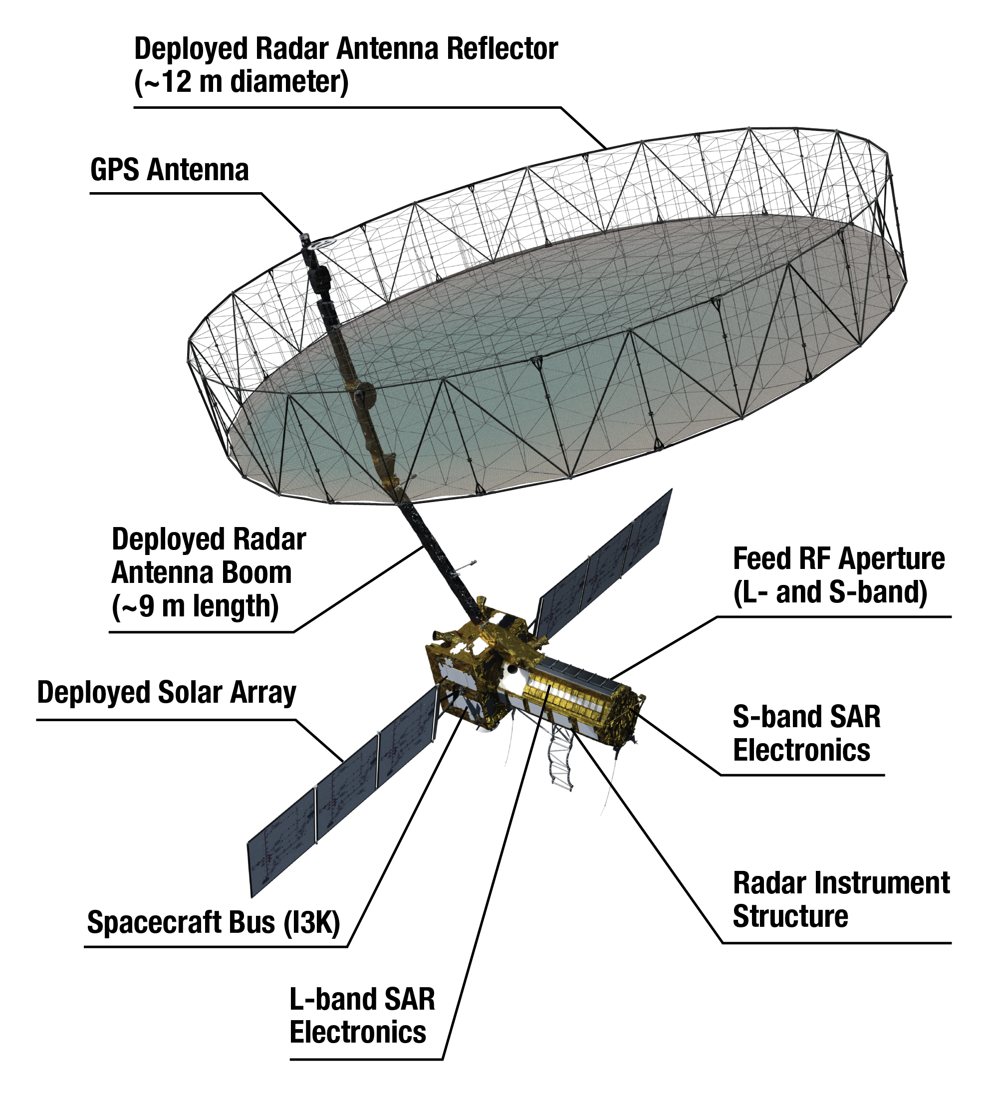
- NISAR is equipped with a massive 12-meter-wide mesh reflector antenna, enabling it to generate annual biomass maps at a resolution of 1 hectare and quarterly maps distinguishing between cultivated and fallow farmland.
- It will also provide detailed floodplain maps and, in emergencies, can generate ‘damage proxy maps’ within five hours of data capture.
- However, there are some limitations. Due to the satellite’s orbital geometry, certain data acquisition modes may not achieve full global coverage. At latitudes above 60º, NISAR will skip every other observation due to overlapping orbits.
- Furthermore, around 10% of Earth’s surface may not be covered from both ascending and descending passes within a given 12-day cycle
|
Another important component of the satellite is its large 39-foot stationary antenna reflector.
Made of a gold-plated wire mesh, the reflector will be used to focus " the radar signals emitted and received by the upward-facing feed on the instrument structure".
|
.png)
- When NASA and ISRO agreed to collaborate on the NISAR project, both agencies committed to contributing equally in terms of funding, technology, and expertise.
- ISRO was responsible for providing the I-3K satellite bus — the core spacecraft framework that handles system commands, propulsion, orientation, and includes solar panels capable of generating 4 kW of power.
- In addition, ISRO delivered the complete S-band radar electronics system, a high-speed Ka-band communication unit, and a steerable high-gain antenna. The development of the S-band radar components was carried out at the Space Applications Centre in Ahmedabad.
- On the other hand, NASA’s primary input was the L-band synthetic aperture radar system. This was developed at the Jet Propulsion Laboratory (JPL), which supplied all related radio-frequency components, a 12-meter radar antenna, a 9-meter carbon fiber boom, and the structural assembly that supports both radar units.
- NASA also provided the L-band feed array and avionics systems, including a solid-state recorder with large data capacity, a GPS system, autonomous data management tools, and a Ka-band communication unit.
- After integration of the radar payloads at JPL, the spacecraft was sent to ISRO’s Satellite Centre in Bengaluru for final assembly. Once fully tested, NISAR will be launched aboard ISRO’s GSLV Mk-II rocket from the spaceport in Sriharikota, with ISRO overseeing the entire launch sequence.
- While the overall mission will be coordinated through NASA's Mission Operations Center at JPL, routine flight control and monitoring will be managed by ISRO’s Telemetry, Tracking and Command Network (ISTRAC) in Bengaluru.
- After deployment into orbit, the bulk of the mission’s data—approximately 3 terabytes daily—will be transmitted through NASA’s Near Earth Network ground stations located in Alaska, Norway’s Svalbard, and Punta Arenas in Chile.
- These facilities will work in conjunction with ISRO’s data reception stations in Shadnagar and Antarctica. Once the raw data are received, India’s National Remote Sensing Centre (NRSC) will process and distribute mission outputs tailored for Indian applications, in a workflow that parallels NASA’s global data distribution system
5. The Mission
- Once launched into space, NISAR will observe subtle changes in Earth's surfaces, helping researchers better understand the causes and consequences of such phenomena.
- It will spot warning signs of natural disasters, such as volcanic eruptions, earthquakes and landslides.
- The satellite will also measure groundwater levels, track flow rates of glaciers and ice sheets and monitor the planet's forest and agricultural regions, which can improve our understanding of carbon exchange.
|
By using synthetic aperture radar (SAR), NISAR will produce high-resolution images.
SAR is capable of penetrating clouds and can collect data day and night regardless of the weather conditions. The instrument's imaging Swath the width of the strip of data collected along the length of the orbit track is greater than 150 miles (240 kilometres), which allows it to image the entire Earth in 12 days. |
- NISAR is expected to be launched in January 2024 from Satish Dhawan Space Centre into a near-polar orbit.
- The satellite will operate for a minimum of three years.
- NASA requires the L-band radar for its global science operations for at least three years.
- Meanwhile, ISRO will utilise the S-band radar for a minimum of five years.
For Prelims & Mains
|
For Prelims: NISAR (NASA-ISRO Synthetic Aperture Radar), Satish Dhawan Space Centre, Earth-observation satellite, Jet Propulsion Laboratory, L-band and S-band synthetic aperture radar, GPS, GSLV launch system and spacecraft,
For Mains:
1. What is NISAR and Explain its benefits (250 Words)
|
GLACIAL LAKE OUTBURST FLOOD (GLOF)
1. Context
2. About glacial lake outburst flood (GLOF)
- A glacial lake outburst flood (GLOF) is a type of outburst flood caused by the failure of a dam containing a glacial lake.
- An event similar to a GLOF, where a body of water contained by a glacier melts or overflows the glacier, is called a jokulhlaup.
- The dam can consist of glacier ice or a terminal moraine. Failure can happen due to erosion, a buildup of water pressure, an avalanche of rock or heavy snow, an earthquake or cryoseism, volcanic eruptions under the ice, or massive displacement of water in a glacial lake when a large portion of an adjacent glacier collapses into it.
3. About flash flooding
- Flash flooding is a rapid flooding of low-lying areas: washes, rivers, dry lakes and depressions.
- It may be caused by heavy rain associated with a severe thunderstorm, hurricane, or tropical storm, or by meltwater from ice or snow flowing over ice sheets or snowfields.
- Flash floods may also occur after the collapse of a natural ice or debris dam, or a human structure such as a man-made dam, as occurred before the Johnstown Flood of 1889.
- Flash floods are distinguished from regular floods by having a timescale of fewer than six hours between rainfall and the onset of flooding.
3.1. The reason for flash floods
There are several reasons why flash floods can occur, but the most common cause is heavy rainfall. When rain falls too quickly for the ground to absorb it, the water can run off and cause flooding. Flash floods can also be caused by:
- Thunderstorms can produce heavy rainfall, especially slow-moving or stationary thunderstorms.
- Hurricanes and tropical storms can produce heavy rainfall and storm surge, which can lead to flash flooding.
- If a dam or levee fails, it can release a large amount of water that can cause flash flooding downstream.
- Ice jams can form when large chunks of ice break off from a glacier or river and jam together. This can block the flow of water and cause flooding upstream.
- Landslides can block rivers and streams, causing flash flooding downstream.
- Vegetation helps slow the water flow and allows it to infiltrate the ground more easily. Areas with little or no vegetation are more likely to experience flash flooding.
- Urban areas are more likely to experience flash flooding than rural areas. This is because pavement and other impervious surfaces prevent water from infiltrating the ground.
4. How did South Lhonak Lake become susceptible to GLOF?
- Climate change is causing glaciers in the Himalayas to melt at an accelerated rate. This is leading to the formation of new glacial lakes and the expansion of existing ones, such as South Lhonak Lake.
- South Lhonak Lake is located in a steep-sided valley with a narrow outlet. This makes it difficult for water to drain from the lake, increasing the risk of a GLOF.
- South Lhonak Lake is dammed by a moraine, which is a pile of loose rocks and debris.
- Moraines are naturally unstable and can be easily breached by heavy rainfall, earthquakes, or other triggers.
- South Lhonak Lake is a relatively deep lake, with a maximum depth of over 100 meters.
- This means that a large volume of water could be released quickly if the lake dam were to breach.
- South Lhonak Lake is also located in a seismically active region. Earthquakes can destabilize the moraine dam and trigger a GLOF.
|
For Prelims: South Lhonak Lake, Flash Flooding, Glaciers, Glacial Lake Outburst Flood, Sikkam, Climate Change, Teesta River,
For Mains:
1. Describe the environmental and socio-economic impacts of flash floods. How can early warning systems and disaster preparedness help mitigate the risks associated with flash floods? (250 Words)
|
|
Previous Year Questions
1. On the planet earth, most of the freshwater exists as ice caps and glaciers. Out of the remaining freshwater, the largest proportion (UPSC 2013) (a) is found in the atmosphere as moisture and clouds (b) is found in freshwater lakes and rivers (c) exists as groundwater (d) exists as soil moisture Answer: C 2. Consider the following pairs: (UPSC CSE 2019)
Glacier River
1. Bandarpunch Yamuna
2. Bara Shigri Chenab
3. Milam Mandakini
4. Siachen Nubra
5. Zemu Manas
Which of the pairs given above are correctly matched?
A. 1, 2 and 4 B. 1, 3 and 4 C. 2 and 5 D. 3 and 5
Answer: A
3. Consider the following features related to a glacial lake outburst flood (GLOF): (UGC NET Geography 2019)
a. Involves sudden release of meltwater
b. Failure of moraine and ice dam
c. Large downstream discharge causing floods
d. Rapid event casting for few seconds
Select the correct answer from the options given below:
A. (a) and (b) are correct
B. (c) and (d) are correct
C. (a), (b) and (c) are correct
D. (b), (c) and (d) are correct
Answer: C
4. With reference to the Agreement at the UNFCCC Meeting in Paris in 2015, which of the following statements is/are correct? (UPSC 2016)
1. The Agreement was signed by all the member countries of the UN and it will go into effect in 2017
2. The Agreement aims to limit greenhouse gas emissions so that the rise in average global temperature by the end of this century does not exceed 2°C or even 1.5°C above pre-industrial levels.
3. Developed countries acknowledged their historical responsibility in global warming and committed to donate $ 1000 billion a year from 2020 to help developing countries to cope with climate change.
Select the correct answer using the code given below:
A. 1 and 3 only B. 2 only C. 2 and 3 only D. 1, 2 and 3
Answer: B
5. A new type of El Nino called El Nino Modoki appeared in the news. In this context, consider the following statements: (UPSC 2010)
1. Normal El Nino forms in the Central Pacific ocean whereas El Nino Modoki forms in the Eastern Pacific ocean.
2. Normal El Nino results in diminished hurricanes in the Atlantic ocean but El Nino Modoki results in a greater number of hurricanes with greater frequency.
Which of the statements given above is/are correct?
A. 1 only B. 2 only C. Both 1 and 2 D. Neither 1 nor 2
Answer: B
6. La Nina is suspected to have caused recent floods in Australia. How is La Nina different from El Nino? (UPSC 2011)
1. La Nina is characterized by unusually cold ocean temperature in the equatorial Indian Ocean whereas El Nino is characterized by unusually warm ocean temperature in the equatorial Pacific Ocean.
2. El Nino has an adverse effect on the south-west monsoon of India, but La Nina has no effect on the monsoon climate.
Which of the statements given above is/are correct?
A. 1 only B. 2 only C. Both 1 and 2 D. Neither 1 nor 2
Answer: D
7. Consider the following statements: (MPSC 2017)
a. La Nina is a little girl.
b. During the time of La Nina cold water in the ocean rises to the surface.
c. La Nina strengthens the Indian monsoon.
d. During the time of El Nino, trade winds weaken, and warm water moves east in the ocean. Which of the above statements is/are correct?
A. Only a and b B. a, b and c C. Only b and c D. All of the above
Answer: D
8. With reference to Ocean Mean Temperature (OMT), which of the following statements is/are correct? (UPSC 2020)
1. OMT is measured up to a depth of 26°C isotherm which is 129 meters in the south-western Indian Ocean during January-March.
2. OMT collected during January-March can be used in assessing whether the amount of rainfall in monsoon will be less or more than a certain long-term mean.
Select the correct answer using the code given below:
A. 1 only B. 2 only C. Both 1 and 2 D. Neither 1 nor 2
Answer: B
9. With reference to 'Indian Ocean Dipole (IOD)' sometimes mentioned in the news while forecasting Indian monsoon which of the following statements is/are correct? (UPSC 2017)
1. IOD phenomenon is characterised by a difference in sea surface temperature between tropical Western Indian Ocean and tropical Eastern Pacific Ocean.
2. An IOD phenomenon can influence an EI Nino's impact on the monsoon.
Select the correct answer using the code given below:
A. 1 only B. 2 only C. Both 1 and 2 D. Neither 1 nor 2
Answer: B
10. "EL Nino" refers to a temperature anomaly in the ________ ocean. (NTPC 2017)
A. Indian B. Pacific C. Southern D. Atlantic
Answer: B
11. The Ministry of Environment, Forest and Climate Change recently published the draft Environment Impact Assessment (EIA) Notification, in 2020. Which of the following statements is correct about EIA? (Punjab Civil Service 2020)
1. It predicts the effect of a proposed industrial/infrastructural project on the environment.
2. It prevents the proposed activity/project from being approved without proper oversight or taking adverse consequences into account.
3. It compares various alternatives for a project and seeks to identify the one which represents the best combination of economic and environmental costs and benefits.
4. As per the new notification, Coal and non-Coal mineral prospecting and solar photovoltaic projects do not need prior environmental clearance.
Select the correct answer using the code given below:
A. Only 1 and 2
B. Only 2, 3 and 4
C. Only 1, 2 and 3
D. Only 1, 2 and 4
Answer: D
12. In the context of India’s preparation for Climate -Smart Agriculture, consider the following statements: (UPSC 2021)
1. The ‘Climate-Smart Village’ approach in India is part of a project led by the Climate Change, Agriculture and Food Security (CCAFS), an international research program.
2. The project of CCAFS is carried out under the Consultative Group on International Agricultural (CGIAR) headquartered in France.
3. The International Crops Research Institute for the Semi-Arid Tropics (ICRISAT) in India is one of the CGIAR’s research centers.
Which of the statements given above is correct?
(a) 1 and 2 only (b) 2 and 3 only (c) 1 and 3 only (d) 1, 2 and 3
Answer: D
13. Consider the following statements: (UPSC 2017)
1. In India, the Himalayas are spread over five States only.
2. Western Ghats are spread over five States only.
3. Pulicat Lake is spread over two States only.
Which of the statements given above is/are correct?
A. 1 and 2 only B. 3 only C. 2 and 3 only D. 1 and 3 only
Answer: B
14. Which of the following statements in respect of landslides are correct? (NDA 2022) 1. These occur only on gentle slopes during rain.
2. They generally occur in clay-rich soil.
3. Earthquakes trigger landslides.
Select the correct answer using the code given below. A. 1 and 2 B. 2 and 3 C. 1 and 3 D. 1, 2 and 3 Answer: B 15. With reference to River Teesta, consider the following statements: (UPSC 2017)
1. The source of river Teesta is the same as that of Brahmaputra but it flows through Sikkim.
2. River Rangeet originates in Sikkim and it is a tributary of river Teesta.
3. River Teesta flows into the Bay of Bengal on the border of India and Bangladesh.
Which of the statements given above is/are correct?
A. 1 and 3 only B. 2 only C. 2 and 3 only D. 1, 2 and 3
Answer: B 16. Teesta River is the tributary of _______. (Kerala PSC Secretariat Assistant 2018) A. Ganga B. Yamuna C. Brahmaputra D. Narmada Answer: C Mains 1.Describe the various causes and the effects of landslides. Mention the important components of the National Landslide Risk Management Strategy. (2021, GS3)
|
Source: indianexpress
CRYPTO EXCHANGES
1. Context
2. What happened to Binance?
- Crypto exchange Binance handles tens of billions of dollars in trading volumes every day.
- Due to trading controls in the U.S. and strict oversight and registration procedures for crypto businesses, Binance did not allow U.S. customers to trade on Binance.com.
- But it offered the Binance.US trading platform to U.S.based users. The regulator alleged that Binance let “highvalue U.S. customers” access the international Binance.com platform. Binance.US is operated by Binance and BAM Trading Services Inc.
- The regulator alleged that BAM Trading and BAM Management US Holdings, Inc. misled investors about trading controls that did not exist on Binance. US.
- The regulator also stated that Binance and its CEO commingled and diverted customer funds while Mr. Zhao was controlling the operations of Binance.US in secret.
- The SEC has filed 13 charges against Binance entities and Mr. Zhao, alleging that they were “engaged in an extensive web of deception, conflicts of interest, lack of disclosure, and calculated evasion of the law.
3. What happened to Coinbase?
- The regulator alleged that Coinbase evaded disclosure requirements that were put in place to safeguard investors.
- The lawsuit charged that the exchange traded at least 13 crypto tokens that should have been registered.
- Coinbase said in a statement that it will continue its regular operations. Coinbase went public in 2021 during the crypto boom and opened at $381 a share on its first trading day. On Tuesday, the company’s shares were down to $51.61 apiece.
4. How will this impact Binance?
- At the basic level, the regulator’s actions will spook U.S.based crypto traders who use Binance’s services but wish to invest in crypto assets legally.
- The SEC’s message has made it clear that U.S. traders using both Binance.com and Binance.US are in danger of violating the law.
- The SEC also questioned the ability of Binance and its entities to keep its customers’ funds safe.
- “Defendants’ purposeful efforts to evade U.S. regulatory oversight while simultaneously providing securitiesrelated services to U.S. customers put the safety of billions of dollars of U.S. investor capital at risk and Binance’s and Zhao’s mercy.
5. How Binance has responded?
- Binance issued a statement saying that it was disappointed with the SEC and that it had previously cooperated with the regulator's investigations.
- The crypto exchange also accused the SEC of trying to make headlines rather than protecting investors.
- Binance stressed its intention to defend itself “vigorously.” It pointed out that as the U.S. regulator, the SEC’s control over the trading platform was limited because Binance was not a U.S. company.
6. Effect on Crypto Market
- The cryptocurrency market is small and extremely susceptible to shocks and spooks when compared to more mainstream finance sectors.
- After SEC’s lawsuit against Binance, the price of Bitcoin (BTC), the largest cryptocurrency by market capitalization, fell as much as 3.90% to retail at under $26,000.
- The second largest coin, Ether, fell by 2.96% in the same interval to trade below $1,900. Experienced investors may have already taken into account Binance’s legal tangles.
- But new investors may panic and sell their tokens. Others may wait to see how the regulatory landscape changes for the volatile crypto industry.
|
For Prelims: U.S. Securities and Exchange Commission (SEC), Binance, Coinbase, Crypto Currency, Bitcoin, Ether, Blockchain technology.
|
Previous year Question1. With reference to “Blockchain Technology”, consider the following statements: (UPSC 2020)
1. It is a public ledger that everyone can inspect, but which no single user controls.
2. The structure and design of the blockchain are such that all the data in it are about cryptocurrency only.
3. Applications that depend on the basic features of blockchain can be developed without anybody’s permission.
Which of the statements given above is/are correct?
A. 1 only
B. 1 and 2 only
C. 2 only
D. 1 and 3 only
Answer: D
2. With reference to 'Bitcoins', sometimes seen in the news, which of the following statements is/are correct? (UPSC 2016)
1. Bitcoins are tracked by the Central Banks of the countries.
2. Anyone with a Bitcoin address can send and receive Bitcoins from anyone else with Bitcoin address.
3. Online payments can be sent without either side knowing the identity of the other. Select the correct answer using the code given below.
A. 1 and 2 only
B. 2 and 3 only
C. 3 only
D. 1, 2 and 3
Answer: B
3. With reference to Non-Fungible Tokens (NFTs), consider the following statements:(UPSC 2022)
1. They enable the digital representation of physical assets.
2. They are unique cryptographic tokens that exist on a blockchain.
3. They can be traded or exchanged at equivalency and therefore can be used as a medium of commercial transactions.
Which of the statements given above is/are correct?
A. 1 and 2 only
B. 2 and 3 only
C. 1 and 3 only
D. 1, 2 and 3
Answer: A
|
FREE TRADE AGREEMENT
1. Context
2. About the Free Trade Agreement
- A Free Trade Agreement (FTA) is an agreement between two or more countries to reduce or eliminate barriers to trade, such as tariffs, quotas, and subsidies.
- FTAs can also include provisions on other issues, such as investment, intellectual property, and labour standards.
- The goal of an FTA is to promote trade and economic growth between the signatory countries.
- By reducing or eliminating trade barriers, FTAs can make it easier for businesses to export their goods and services to other countries, which can lead to increased production, employment, and innovation.
3. Types of Free Trade Agreement
- Bilateral Free Trade Agreement (BFTA) involves two countries, aiming to promote trade and eliminate tariffs on goods and services between them. It establishes a direct trade relationship, allowing for a more focused and tailored agreement between the two nations.
- Multilateral Free Trade Agreement (MFTA) Involving three or more countries, an MFTA seeks to create a comprehensive trade bloc, promoting economic integration on a larger scale. It requires coordination among multiple parties, addressing diverse economic interests and fostering a broader regional economic landscape.
- Regional Free Trade Agreement (RFTA) involves countries within a specific geographic region, aiming to enhance economic cooperation and integration within that particular area. It focuses on addressing regional economic challenges and fostering collaboration among neighbouring nations.
- Preferential Trade Agreement (PTA) involves a reciprocal reduction of tariffs and trade barriers between participating countries, granting preferential treatment to each other's goods and services. It allows countries to enjoy trading advantages with specific partners while maintaining autonomy in their trade policies with non-participating nations.
- Comprehensive Economic Partnership Agreement (CEPA) is a broad and advanced form of FTA that goes beyond traditional trade barriers, encompassing various economic aspects such as investment, intellectual property, and services. It aims for a more comprehensive economic partnership, encouraging deeper integration and collaboration between participating countries.
- Customs Union While not strictly an FTA, a Customs Union involves the elimination of tariffs among member countries and the establishment of a common external tariff against non-member nations. It goes beyond standard FTAs by harmonizing external trade policies, creating a unified approach to trade with the rest of the world.
- Free Trade Area (FTA) with Trade in Goods (TIG) and Trade in Services (TIS): Some FTAs specifically emphasize either trade in goods or trade in services, tailoring the agreement to the specific economic strengths and priorities of the participating countries. This approach allows nations to focus on areas where they have a comparative advantage, fostering specialization and efficiency.
4. India's Free Trade Agreements
India is a member of several free trade agreements (FTAs) and is currently negotiating others. India's FTAs have helped to reduce trade barriers and promote trade and economic growth. They have also helped to attract foreign investment and create jobs.
- The South Asian Free Trade Agreement (SAFTA) was signed in 1995 by the seven countries of the South Asian Association for Regional Cooperation (SAARC). SAFTA aims to reduce or eliminate tariffs on trade between the member countries.
- The India-Bangladesh FTA was signed in 2010 and came into force in 2011. It is a comprehensive FTA that covers goods, services, and investments.
- The India-Sri Lanka FTA was signed in 1999 and came into force in 2000. It is a comprehensive FTA that covers goods, services, and investments.
- The India-ASEAN Free Trade Agreement was signed in 2002 and came into force in 2010. It is a comprehensive FTA that covers goods, services, and investments.
- The India-Korea Comprehensive Economic Partnership Agreement (CEPA) was signed in 2010 and came into force in 2011. It is a comprehensive FTA that covers goods, services, and investments.
- The India-Japan Comprehensive Economic Partnership Agreement(CEPA) was signed in 2022 and came into effect in 2023. It is a comprehensive FTA that covers goods, services, and investments.
- The India-UAE Comprehensive Partnership Agreement (CEPA) was signed in 2022 and came into effect in 2022. It is a comprehensive FTA that covers goods, services, and investments.
- The India-Australia Economic Cooperation and Trade Agreement (ECTA) was signed in 2022 and came into effect in 2022. It is a comprehensive FTA that covers goods, services, and investments.
- The India-Malaysia Comprehensive Economic Cooperation Agreement (CECA) was signed in 2010 and aims to enhance economic ties by addressing trade in goods and services, as well as investment and other areas of economic cooperation.
- The India-Thailand Free Trade Agreement was signed in 2003 and focuses on reducing tariffs and promoting trade in goods and services between India and Thailand.
- The India-Singapore Comprehensive Economic Cooperation Agreement (CECA) has been operational since 2005, this agreement covers trade in goods and services, as well as investment and intellectual property.
- The India-Nepal Trade Treaty While not a comprehensive FTA, India and Nepal have a trade treaty that facilitates the exchange of goods between the two countries.
- The India-Chile Preferential Trade Agreement was signed in 2006 and aims to enhance economic cooperation and reduce tariffs on certain products traded between India and Chile.
5. India - UK Free Trade Agreement
5.1. Background
- Both countries have agreed to avoid sensitive issues in the negotiations.
- The interim (early harvest agreement) aims to achieve up to 65 per cent coverage for goods and up to 40 per cent coverage for services.
- By the time the final agreement is inked, the coverage for goods is expected to go up to "90 plus a percentage" of goods.
- India is also negotiating a similar early harvest agreement with Australia, which is supposed to set the stage for a long-pending Comprehensive Economic Cooperation Agreement that both countries have been pursuing for nearly a decade.
- While the commencement of negotiations does mark a step forward in the otherwise rigid stance adopted and when it comes to trade liberalisation, experts point to impediments and the potential for legal challenges going ahead.
5.2. GATT (General Agreement on Trade and Tariffs)
- The exception to the rule is full-scale FTAs, subject to some conditions.
- One rider, incorporated in Article XXIV.8 (b) of GATT, stipulates that a deal should aim to eliminate customs duties and other trade barriers on "Substantially all the trade" between the WTO member countries that are signatories to an FTA.
- For this Agreement, a free-trade area shall be understood to mean a group of two or more customs territories in which the duties and other restrictive regulations of commerce are eliminated on substantially all the trade between the constituent territories in products originating in such territories.
- It is often beneficial to negotiate the entire deal together, as an early harvest deal may reduce the incentive for one side to work towards a full FTA.
- These agreements are not just about goods and services but also issues like investment.
- If you are trying to weigh the costs and benefits, it is always better to have the larger picture in front of you.
- In the case of the early harvest agreement inked with Thailand, automobile industry associations had complained that relaxations extended to Bangkok in the early harvest had reduced the incentive for Thailand to work towards a full FTA.
- Early harvest agreements may serve the function of keeping trading partners interested as they promise some benefits without long delays, as India becomes known for long-drawn negotiations for FTAs.
- Government emphasis on interim agreements may be tactical so that a deal may be achieved with minimum commitments and would allow for contentious issues to be resolved later.
|
For Prelims: Free Trade Agreement, India-U.K, Bilateral Free Trade Agreement, G-20 Summit, Agenda 2030, Covid-19 Pandemic, SAARC, General Agreement on Trade and Tariffs, Comprehensive Economic Partnership Agreement, Multilateral Free Trade Agreement, Regional Free Trade Agreement, Preferential Trade Agreement, Customs Union,
For Mains:
1. Evaluate the potential impact of the India-UK FTA on the Indian economy, considering both positive and negative aspects (250 Words)
2. Critically evaluate the significance of Free Trade Agreements (FTAs) in promoting trade and economic growth, considering their potential benefits and drawbacks. (250 Words)
|
|
Previous Year Questions
1. Consider the following countries:
1. Australia
2. Canada
3. China
4. India
5. Japan
6. USA
Which of the above are among the free-trade partners' of ASEAN? (UPSC 2018)
A. 1, 2, 4 and 5 B. 3, 4, 5 and 6 C. 1, 3, 4 and 5 D. 2, 3, 4 and 6
Answer: C
2. Increase in absolute and per capita real GNP do not connote a higher level of economic development, if (UPSC 2018) (a) Industrial output fails to keep pace with agricultural output. Answer: C 3. The SEZ Act, 2005 which came into effect in February 2006 has certain objectives. In this context, consider the following: (2010)
Which of the above are the objectives of this Act? (a) 1 and 2 only (b) 3 only (c) 2 and 3 only (d) 1, 2 and 3 Answer: A 4. A “closed economy” is an economy in which (UPSC 2011) (a) the money supply is fully controlled Answer: D 5. With reference to the “G20 Common Framework”, consider the following statements: (UPSC 2022)
1. It is an initiative endorsed by the G20 together with the Paris Club. 2. It is an initiative to support Low Income Countries with unsustainable debt. Which of the statements given above is/are correct? (a) 1 only (b) 2 only (c) Both 1 and 2 (d) Neither 1 nor 2 Answer: C
|
JAL JEEVAN MISSION
-
The Jal Jeevan Mission, launched by Prime Minister Narendra Modi on August 15, 2019, was envisioned to ensure tap water access to approximately 16 crore rural households, with the goal of achieving universal coverage by 2024.
-
However, in just over five years, only 75% of the target has been met. To cover the remaining 4 crore households, the government now plans to extend the mission’s deadline to December 31, 2028.
-
The Ministry of Jal Shakti had sought Rs 2.79 lakh crore from the Centre to finish the project. But according to sources, the Expenditure Finance Committee (EFC)—headed by the Expenditure Secretary—reviewed the proposal on March 13 and recommended a revised funding of only Rs 1.51 lakh crore. The committee also slashed the total project cost by Rs 41,000 crore, approving an outlay of Rs 8.69 lakh crore instead of the Rs 9.10 lakh crore originally proposed.
-
Since the Jal Jeevan Mission is co-financed equally by the Centre and the states, this cut in Central funding could shift a greater financial burden onto state governments
|
Government Schemes related to Water
Among the various initiatives under the Ministry of Jal Shakti, the Namami Gange Programme and river interlinking projects hold significant importance. Hence, it is essential for aspirants to not only be familiar with these schemes but also grasp the concept of river interlinking itself. In fact, a previous Prelims question was based on the Godavari-Krishna river interlinking, highlighting the relevance of such topics. As a result, gaining a clear understanding of the Ken-Betwa river linking project is also crucial for exam preparation
|
-
The Namami Gange Programme is a comprehensive river conservation initiative launched as a flagship mission by the Union Government in June 2014. It aims to achieve two primary goals: the reduction of pollution and the revival and preservation of the Ganga River, recognized as India’s national river.
-
The programme is built on several core components, which include:
-
Development of sewage treatment infrastructure
-
Revitalization of riverfront areas
-
Cleaning of the river surface to remove floating waste
-
Promotion and protection of biodiversity
-
Expansion of afforestation along the river basin
-
Enhancing public engagement and awareness
-
Monitoring of industrial waste discharge
-
Transformation of villages along the Ganga into model Ganga Grams
-
-
River interlinking refers to a large-scale water resource management approach where water is deliberately redirected from regions with excess availability to those facing water scarcity.
-
This method typically involves connecting river basins using infrastructure such as canals, reservoirs, and pipelines. These inter-basin water transfer (IBWT) projects are designed to improve irrigation capacity, support flood management, and boost water availability in areas prone to drought.
-
On December 25, 2024, Prime Minister Narendra Modi inaugurated the Ken-Betwa Link Project (KBLP) in Khajuraho, Madhya Pradesh, marking the 100th birth anniversary of former PM Atal Bihari Vajpayee.
-
The project’s primary goal is to irrigate the drought-prone Bundelkhand region by channeling excess water from the Ken River in Madhya Pradesh to the Betwa River in Uttar Pradesh. Both rivers eventually feed into the Yamuna River, and are classified as its right-bank tributaries.
-
The Union Cabinet approved a budget of Rs 44,605 crore for the KBLP. It will be implemented in two phases:
-
Phase I includes the construction of the Daudhan Dam, a 221-km-long Ken-Betwa Link Canal, and associated infrastructure.
-
Phase II will involve the development of the Lower Orr Dam, the Bina Complex Project, and the Kotha Barrage.
-
-
A section of the proposed infrastructure will pass through the Panna Tiger Reserve, raising environmental concerns due to the potential submergence of a part of this ecologically sensitive tiger habitat.
-
Significantly, the KBLP is the first river interlinking project to be implemented under the National Perspective Plan, which was introduced in 1980. This larger plan includes 16 river links in the Peninsular region, and another 14 links proposed under the Himalayan component
|
Yamuna river
Yamuna is a tributary of River Ganga. It has four main tributaries in the Himalayan region: Rishi Ganga, Hanuman Ganga, Tons, and Giri. In the plains, the main tributaries are Hindon, Chambal, Sind, Betwa and Ken. Tons is the largest tributary of Yamuna. Other small tributaries of the Yamuna River include the Uttangan, Sengar and the Rind.
|
Right to Water as a Fundamental Right in India
The right to access clean and safe drinking water in India is considered part of the fundamental rights framework, particularly under Article 21 of the Constitution, which guarantees the Right to Life. This interpretation is derived from connected rights such as the right to food, right to health, and the right to a clean environment.
-
In the landmark Narmada Bachao Andolan v. Union of India (2000) case, the Supreme Court emphasized that access to water is a basic human necessity, integral to the right to life. It also stated that the right to a healthy environment and sustainable development are essential components of human rights under Article 21.
-
Similarly, in the State of Karnataka v. State of Andhra Pradesh (2000) case, the Court reiterated that the right to water is part and parcel of the right to life, thus making it a fundamental right
Directive Principles Related to Water and Environment
-
Article 39(b) under the Directive Principles of State Policy directs the State to ensure that material resources, including water, are equitably distributed to promote the common good.
-
Article 48A calls upon the State to actively work towards the protection and enhancement of the environment, including forests and wildlife, which indirectly contributes to water conservation
Environmental Duties of Citizens
-
Article 51A(g), which falls under Fundamental Duties, obligates every citizen to safeguard and improve the natural environment, specifically mentioning rivers, lakes, forests, and wildlife. It also encourages compassion for living beings
Legal Provisions for Water Dispute Resolution
-
Article 262 empowers Parliament to enact laws for resolving inter-State river water disputes. According to:
-
Clause (1): Parliament can legislate for the adjudication of conflicts over the use, distribution, or control of inter-State river waters.
-
Clause (2): Parliament may restrict judicial intervention, including that of the Supreme Court, in such matters.
This article served as the constitutional basis for the enactment of the Inter-State River Water Disputes Act, 1956, aimed at resolving such disputes
-
Constitutional Powers over Water – State and Union Roles
-
Entry 17 of the State List (List II), Seventh Schedule grants states the authority to legislate on water-related issues like irrigation, canals, drainage, and water supply, subject to the Union’s jurisdiction under Entry 56 of List I.
-
Entry 56 of the Union List (List I), Seventh Schedule allows the central government to regulate and develop inter-State rivers and river valleys when declared to be in the public interest by Parliament
|
For Prelims: Jal jeevan Mission, Directive Principles of State Policy
For Mains: GS II - Government Schemes on Water
|
CHOLAS
2.Cholas in South India
- Terms of the scale of accomplishments in art and architecture and the wealth of writing and epigraphic records, the Cholas would come across as one of the richest dynasties in South Indian history
- There is a profusion of inscriptions that give meticulous details about administration, social life, and material culture… The Brihadeshwara Temple alone which was consecrated in 1010 CE by Rajaraja I has nearly a hundred inscriptions.
- It is also claimed that the Cholas were one of the longest recorded dynasties in world history
- At the peak of their rule in the ninth and tenth centuries, the entire area south of the Tungabhadra River was brought together as a single unit under the Cholas.
- They were perhaps the only dynasty from Southern India to have moved north, marching into Eastern India, where Rajendra Chola is known to have defeated the Pala king of Pataliputra
- They were also the first empire with grand commercial and territorial ambitions outside of the Indian subcontinent
3.About Cholas
- The earliest references to the Cholas date as far back as the third century BCE and were made by the Mauryan emperor Ashoka
- However, very little evidence exists about the early Cholas, apart from the early Tamil literature of the third Sangam, and the references made about them in an ancient Graeco-Roman periplus written in the early centuries of the Common Era.
- The Chola Empire as we know it in all its glory emerged sometime in the mid-ninth century under King Vijayalaya Chola
- The dynasty of Vijayalaya left behind a vast number of stone inscriptions and some copper plate grants, which have, in the last few decades, been the main source for reconstructing the history of the Cholas.
- The Chola empire was at its most expansive under Arulmozhivarman, who on acceding to the throne in 985 CE, adopted the regnal title of Rajaraja or king of kings
- The doyen of South Indian history, Nilakantha Sastri, in his 1955 book The Cholas, writes that under Rajaraja I and his successors, the Chola Empire had reached the capacity of ‘Byzantine royalty’ “with its numerous palaces, officials and ceremonials and its majestic display of the concentrated resources of an extensive empire.”
- According to Sastri, with the emergence of Rajaraja I, the monarchy underwent a substantial transformation, with the king now becoming an emperor. In his official records, Rajaraja I was referred to as the “emperor of the three worlds” or as possessing the whole universe.
4.Cholas vs Pandyas
|
The Cholas, along with the Pandyas of Madurai and the Cheras were the three great kingdoms of ancient Tamilakam which roughly corresponds to present-day Tamil Nadu, Kerala, Puducherry, Lakshadweep and the southern parts of Andhra Pradesh and Karnataka
By the time Rajaraja I came to the throne, the Cholas had gained the upper hand over the Pandyas and emerged as the primary power in the northern and eastern parts of the Tamil country.
|
5.Cholas Expeditions
- Rajaraja Chola established himself as one of the most astute political and military strategists that southern India had ever seen
- By the close of the 10th century, he had overrun almost all of the Pandya territories and appointed his own governors there
- He then moved to Sri Lanka, ransacking some of the greatest of Buddhist viharas and establishing the presence of the Cholas through the building of Shiva temples.
- The expansion of the Chola empire continued under Rajaraja Chola’s son, Rajendra Chola, also known as Rajendra the Great or Gangaikonda Chola (the Chola who conquered Ganga)
- He built the Chola capital at Gangaikondacholapuram (close to present-day Tiruchirapalli) to commemorate his victory over the Pala dynasty in present-day Bengal in 1025 CE.
- He then erected a gigantic Shiva temple in it as a mark of thanksgiving to the lord.
- Rajendra became one of the only Indian monarchs to conquer territory outside the Indian subcontinent
- In 1025 CE, he sent a naval expedition to Indochina, the Malay Peninsula and Indonesia. His expansion to Southeast Asia was crucial in establishing trade and cultural links with the region
- The influence of the Cholas can be seen in the language and society of large parts of Southeast Asia as well
- The deification of kings in Cambodia and Thailand as incarnations of Brahmanical Gods, for instance, is a most evident imprint of the Cholas.
- The medieval Chola empire began to decline in 1070 CE, after the death of Virarajendra Chola, the son of Rajendra Chola.
- A period of chaos prevailed, which ended with the emergence of the Later Cholas, a dynasty that was the product of alliances between the Cholas and the Eastern Chalukyas.
6. Gangaikonda cholapuram
.png)
- Before Rajendra I, the Chola throne was held by his father, the renowned Rajaraja I, who was responsible for constructing the iconic Brihadeeswara Temple in Tanjore (modern-day Thanjavur).
- The term ‘Brihadeeswara’ translates to ‘great’ or ‘massive’—with ‘brihad’ in Sanskrit signifying largeness. Interestingly, this term is also associated with the temple established by Rajendra I, as listed in UNESCO’s World Heritage records.
- The Gangaikonda Cholapuram Temple, dedicated to Lord Shiva and recognized as a UNESCO World Heritage Site, is often regarded as the zenith of Chola architectural achievement.
- It stands as a monumental symbol of the Chola Empire’s grandeur, reflecting an era when its influence extended from the banks of the Ganga in northern India to regions of Southeast Asia, including Sumatra, Malaysia, and Myanmar.
- Built around 1030 CE, roughly 20 years after the Brihadeeswara Temple, Rajendra’s temple followed a similar architectural style but displayed greater intricacy and finesse.
- This stylistic richness mirrors the Chola Empire’s prosperity during his reign. While the Tanjore temple features a tall, upright tower projecting power and dominance, the Gangaikonda Cholapuram temple is distinguished by its graceful curves and refined form—signaling a more confident and aesthetically sophisticated expression of imperial strength.
- Even today, the temple remains a vibrant cultural center, especially during the Aadi Thiruvadhirai festival. ‘Aadi’ refers to the Tamil month, and ‘Thiruvadhirai’ is a star (nakshatra) traditionally associated with Lord Shiva and believed to be Rajendra I’s birth star. As part of the festivities, therukoothu (street theatre) performances reenact the king’s accomplishments, and his statue is ceremonially adorned with new silk garments
7.Art & Culture
- From the 10th century onward, the Cholas more prominently started making structural temples
- The gigantic Brihadeshwara Temple in Thanjavur is perhaps one of the finest examples of the Cholas’ artistic brilliance
- Inscriptional evidence in Chola art also points to the prominent role played by royal women and dancers in the patronage of art and architecture
- One of the most celebrated patrons was the widowed queen of Gandaraditya Chola, Sembiyan Mahadevi.
- An avid temple builder, she is well known for her contributions to temples such as Umamaheshvar Temple at Konerirajapuram, Tirukkurangaduturai Temple at Aduturai, Tirukkotisvarar Temple at Tirukkodikkaval among other
- Under the Chalukyas you had the basic design of the structural temples coming in and under the Pallavas, the rock-cut temple art emerged. But it is the scale of temple building activities under the Cholas that mark them out
- The pyramidal vimana of the Brihadeshwara temple of 66 metres is one of the tallest buildings in antiquity
- The Gangaikonda Cholapuram temple with its catenary-shaped vimana is also a unique engineering marvel


|
For Prelims: Chola Dynasty, Gangaikonda cholapuram, Raja raja I
For Mains: GS I - Art & Culture
|


