PURCHASING MANAGERS INDEX (PMI)
- PMI is typically calculated through surveys of purchasing managers in various industries. These managers are asked about their perception of different aspects of business activity, including new orders, production levels, employment, supplier deliveries, and inventories.
- PMI is usually reported as a number between 0 and 100.
- A PMI value above 50 generally indicates expansion in the sector, while a value below 50 suggests contraction. The farther the PMI is from 50, the stronger the perceived expansion or contraction.
- PMI is considered a leading indicator because it provides insights into economic conditions before official economic data, such as GDP growth or employment figures, are released. It can be used to anticipate changes in economic activity.
- PMIs are calculated separately for manufacturing and services sectors. A Manufacturing PMI focuses on the manufacturing sector, while a Services PMI provides insights into the services sector. These sector-specific PMIs can give a more detailed view of the economy.
Components: PMI is composed of several components, including:
- New Orders: This component measures the number of new orders received by businesses. An increase in new orders often signals growing demand and economic expansion.
- Production: This component reflects changes in production levels. An increase suggests increased economic activity.
- Employment: The employment component indicates changes in the level of employment within the sector. An increase typically means job growth.
- Supplier Deliveries: This measures the speed at which suppliers can deliver materials. Slower deliveries may indicate supply chain issues or increased demand.
- Inventories: Inventory levels can be an indicator of expected demand. A decrease in inventories might suggest an expectation of rising demand.
- The Purchasing Managers' Index (PMI) is a significant economic indicator with several important implications and uses
- PMI serves as a barometer of the economic health of a country or region. A PMI above 50 generally indicates economic expansion, while a PMI below 50 suggests contraction.
- This provides a quick and easily understandable snapshot of the direction of economic activity, making it a valuable tool for assessing the overall economic climate.
- PMI is a leading indicator, meaning it often provides insights into economic conditions ahead of other official economic data, such as GDP growth or employment figures. As such, it is used by businesses, investors, and policymakers to anticipate changes in economic activity and make informed decisions
|
Previous Year Questions
1.What does S & P 500 relate to? (UPSC CSE 2008) (a) Supercomputer Answer: (d) |
CRIME IN INDIA
1. Context
2. NCRB 2022 Report
The National Crime Records Bureau (NCRB) released its annual report on crime in India for the year 2022 on December 3, 2023. The data cover overall crimes, and separately note crimes against women, Scheduled Castes (SCs) and Scheduled Tribes (STs), cyber crimes, etc. Here are some takeaways from the latest report:
- In 2022, a total of 58,24,946 cognizable crimes were recorded, consisting of 35,61,379 Indian Penal Code (IPC) crimes and 22,63,567 Special & Local Laws (SLL) crimes. This marked a 4.5% decline in case registrations compared to the preceding pandemic year, 2021.
- The crime rate, measured as crimes registered per lakh population, decreased from 445.9 in 2021 to 422.2 in 2022. This metric is considered more informative, as it accounts for population fluctuations and provides a nuanced perspective on crime trends.
- Crimes against women saw an uptick, with 4,45,256 cases registered in 2022—a 4% increase from the 2021 figures. The majority of crimes against women under IPC sections were categorized as 'Cruelty by Husband or His Relatives' (31.4%), followed by 'Kidnapping & Abduction of Women' (19.2%), and 'Assault on Women with Intent to Outrage her Modesty' (18.7%).
- Cybercrime reporting experienced a notable surge, escalating by 24.4 percentage points compared to 2021, with 65,893 cases documented. The majority of registered cases were related to fraud (64.8%), followed by extortion (5.5%), and sexual exploitation (5.2%).
- Suicides reported in 2022 increased by 4.2% (1,70,924 suicides) compared to 2021. The leading reasons for suicides were 'Family Problems (other than marriage-related problems)' (31.7%), 'Marriage Related Problems' (4.8%), and 'Illness' (18.4%), collectively accounting for 54.9% of total suicides. The male-to-female ratio of suicide victims was 71.8:28.2.
3. How the NCRB Compiles its Reports
- The National Crime Records Bureau (NCRB) is tasked with compiling and maintaining records of crime data in India. Functioning as a "national warehouse" for fingerprint records of both Indian and foreign criminals, it aids in identifying interstate criminals through fingerprint searches.
- For its primary annual publication, the Crime in India reports, the NCRB collates information from the police forces of 36 states and Union Territories. Additionally, data is collected from 53 cities with populations exceeding 10 lakh each, based on the 2011 Census, through the respective state-level crime records bureaus.
- The process of data compilation begins at the local police station level, where state/Union Territory police input information. Subsequently, the data undergoes validation at the district and state levels before final verification by the NCRB. This meticulous validation process ensures the accuracy and reliability of the crime data reported in the NCRB's flagship annual reports.
- The latest NCRB report highlights state-wise trends, indicating that Kerala (96.0%), Puducherry (91.3%), and West Bengal (90.6%) have the highest charge sheeting rates under IPC crimes.
- This metric represents the percentage of cases where the police progressed to framing charges against the accused, considering both the total true cases (where a charge sheet was not laid but a final report submitted as true) and the total cases charge-sheeted.
- However, it's crucial to note that a high charge sheeting rate does not necessarily imply that these states are more crime-prone than others.
- The NCRB report emphasizes that the data record the incidence of registered crime, not the actual occurrence of crime. This distinction is significant and acknowledges the limitations of the data.
- For example, when reported crimes against women in Delhi increased significantly after the 2012 bus gang rape case, it might reflect heightened awareness about the importance of registering crimes. This increased awareness could be among those affected and within the police force, rather than indicating an actual surge in the incidence of crime against women. Therefore, the interpretation of state-wise data should consider factors such as reporting practices, public awareness, and law enforcement efforts.
4. Limitations of the data
- Indeed, there are additional complexities and limitations associated with the data compiled by the NCRB.
- One significant issue stems from the NCRB's adherence to the 'Principal Offence Rule.' According to this rule, in cases where multiple offences are registered in a single First Information Report (FIR), the crime with the most severe punishment is considered the primary counting unit.
- This means that, for instance, 'Murder with Rape' would be categorized as 'Murder,' potentially leading to an undercounting of specific crimes, such as rape.
- Moreover, the NCRB report relies on data submitted at the local level, introducing potential inefficiencies and gaps that can impact the accuracy of the overall report.
- A case in point, as highlighted by a report involves the recording of farmer suicides. The cause of suicide recorded in the FIR is heavily dependent on the understanding of the situation by the attending police officer, potentially resulting in inaccuracies.
- For example, a farmer's suicide may be attributed to a quarrel over money in the FIR, while the underlying cause might be farm distress due to crop failure, leading to indebtedness and financial difficulties.
- The NCRB itself acknowledges that it does not capture the socio-economic causative factors or reasons behind crimes.
- This limitation is particularly evident in cases where certain groups may be hesitant to register cases due to fear of an uncooperative or hostile response from the police.
- Additionally, a shortage of police officers or unfilled vacancies at the local level may impede the collection of comprehensive and accurate data.
- Therefore, while the NCRB report provides valuable insights, it is essential to approach the data with an awareness of these inherent limitations and nuances.
5. National Crime Records Bureau (NCRB)
- The National Crime Records Bureau was established in 1986 and serves as the central repository of crime and criminal information for India.
- This vital agency, born from the recommendations of the Tandon Committee and the MHA's Taskforce, plays a pivotal role in keeping track of crime and criminals across the nation.
- One of NCRB's most significant responsibilities is managing the Crime and Criminal Tracking Network & Systems (CCTNS) project Launched in 2009, this project connects over 15,000 police stations and 6,000 higher police offices, enabling seamless information sharing and coordinated action.
- But NCRB's reach extends beyond just data collection. In 2017, they launched the National Digital Police Portal, empowering citizens to search for criminals and suspects directly within the CCTNS database. This initiative puts the power of information directly in the hands of the people.
- NCRB's commitment to public safety goes further. They maintain the National Database of Sexual Offenders (NDSO), ensuring vital information about these perpetrators is readily available to states and union territories.
- Additionally, they act as the central hub for the Online Cyber-Crime Reporting Portal, managing both technical and operational aspects of this crucial platform.
6. Way Forward
It is imperative to acknowledge the comprehensive insights provided by the NCRB report on crime in India, while also recognizing the inherent limitations and complexities in the data compilation process. To enhance the effectiveness and accuracy of future reports, Refinement of Data Collection Methods, Review and Update Reporting Practices, Enhanced Socio-Economic Analysis, Public Awareness Initiatives, Addressing Vacancies and Resource Gaps, Continuous Improvement of Technology Platforms and Stakeholder Collaboration. By addressing these aspects, India can work towards refining its crime reporting mechanisms, fostering greater accuracy and transparency in the compilation and analysis of crime data. This, in turn, will contribute to more effective policy formulation and law enforcement strategies aimed at ensuring the safety and well-being of its citizens.
|
For Prelims: National Crime Records Beaure, Suicides, Murder, Rape, FIR, cyber crimes, Tandon Committee, MHA's Taskforce, National Database of Sexual Offenders, Crime and Criminal Tracking Network & Systems, Indian Penal Code
For Mains:
1. Analyze the significance of the National Crime Records Bureau (NCRB) in maintaining a national database of crime and criminals in India. Discuss the limitations of the data collected by the NCRB and suggest ways to improve its accuracy and comprehensiveness. (250 Words)
|
|
Previous Year Questions
1. Which one of the following explains the practice of 'Vattakirutal' as mentioned in Sangam poems? (UPSC 2023)
A. Kings employing women bodyguards
B. Learned persons assembling in royal courts to discuss religious and philosophical matters
C. Young girls keeping watch over agricultural fields and driving away birds and animals
D. A king defeated in a battle committing ritual suicide by starving himself to death
2. With reference to India, consider the following statements: (UPSC 2021)
1. When a prisoner makes out a sufficient case, parole cannot be denied to such prisoner because it becomes a matter of his/her right.
2. State Governments have their own Prisoners Release on Parole Rules.
which of the statements given above is/are correct?
A. 1 only B. 2 only C. Both 1 and 2 D. Neither 1 nor 2
3. In India, under cyber insurance for individuals, which of the following benefits are generally covered, in addition to payment for the loss of funds and other benefits? (UPSC CSE 2020)
1. Cost of restoration of the computer system in case of malware disrupting access to one's computer
2. Cost of a new computer if some miscreant wilfully damages it, if proved so
3. Cost of hiring a specialized consultant to minimize the loss in case of cyber extortion
4. Cost of defence in the Court of Law if any third party files a suit
Select the correct answer using the code given below:
A. 1, 2 and 4 only B. 1, 3 and 4 only C. 2 and 3 only D. 1, 2, 3 and 4
Answers: 1-D, 2-B, 3-D
Mains
1. Why suicide among young women is increasing in Indian society? (UPSC 2023)
|
GLOBAL POSITIONING SYSTEM (GPS)
- The Global Positioning System (GPS) is a network of satellites that orbit the Earth and provide precise location and time information to GPS receivers anywhere on or near the Earth. Originally developed by the United States Department of Defense for military applications, GPS has become widely used in various civilian applications like navigation, mapping, surveying, and outdoor activities.
- GPS works by triangulating signals from multiple satellites to determine the receiver's exact location, typically using signals from at least four satellites to pinpoint a specific position. Each satellite broadcasts signals containing its own location and the precise time the signal was transmitted.
- By measuring the time it takes for the signals to reach the receiver, the GPS device can calculate how far away each satellite is and use this information to determine its own location through a process called trilateration.
- Apart from navigation in vehicles and smartphones, GPS technology has found applications in agriculture, aviation, disaster management, tracking systems, and more due to its accuracy and reliability in determining precise geographic coordinates
3. History of GPS
The history of GPS dates back to the 1960s when the United States began developing the technology for military purposes. Here's a brief timeline of the significant milestones in GPS development:
1960s: The U.S. Department of Defense starts experimenting with satellite-based navigation systems. The system was initially called NAVSTAR (Navigation System with Timing and Ranging).
1973: Physicist and engineer Ivan Getting proposed the concept of a global positioning system using satellites in geostationary orbits. This idea later evolved into the GPS we know today.
1978: The first experimental Block-I GPS satellite was launched, initiating the development of the operational system.
1983: Korean Air Lines Flight 007, a passenger jet, was shot down after straying into Soviet airspace due to navigational errors. This incident accelerated the development and deployment of GPS for civilian use to prevent similar tragedies.
1993: GPS achieved full operational capability with a complete constellation of 24 satellites in orbit.
Late 1990s: Selective Availability (SA), intentional degradation of GPS signals for civilian users, was turned off, significantly improving the accuracy of civilian GPS receivers.
2000s: With advancements in technology, the use of GPS became widespread in various civilian applications, including navigation devices, smartphones, agriculture, surveying, and more.
Modern Developments: Over time, the system has seen upgrades, including the launch of new satellites (modernized Block IIR, IIR-M, IIF, and GPS III satellites), improved accuracy, and the integration of other satellite systems like GLONASS (Russia), Galileo (Europe), and BeiDou (China) for enhanced global coverage and accuracy.
GPS has evolved from a purely military technology into an integral part of everyday life, powering various industries and navigation systems worldwide. Its accuracy and reliability continue to improve with ongoing technological advancements
4. How does the Global Positioning System Work?
The Global Positioning System (GPS) works through a network of satellites orbiting the Earth. Here's a simplified breakdown of how GPS functions:
Satellite Constellation: The GPS system consists of at least 24 satellites orbiting the Earth. These satellites are placed in such a way that at any given time and place on Earth, there are usually multiple satellites visible in the sky.
Triangulation: A GPS receiver on the ground or in a device, such as a smartphone or a GPS unit, communicates with these satellites by receiving signals from them. To determine its location, the receiver needs signals from at least four satellites. This is because each satellite sends out signals containing information about its location and the exact time the signal was transmitted.
Calculating Distance: The GPS receiver calculates its distance from each satellite by measuring the time it takes for the signals to travel from the satellites to the receiver. Since the speed of the signal is known (the speed of light), the receiver can calculate how far away each satellite is based on the time it took for the signal to arrive.
Trilateration: Once the receiver has gathered distance measurements from at least four satellites, it uses a process called trilateration. Trilateration involves intersecting spheres (or in this case, spheres in three dimensions) to determine the precise location where the spheres intersect. In GPS, these spheres are representations of the distances from each satellite. By finding the intersection point of these spheres, the receiver can calculate its exact position on Earth in terms of latitude, longitude, and altitude.
Data Processing: Once the receiver has calculated its position based on signals from multiple satellites, it uses this information along with maps or other geographical data to display the location or provide navigational instructions to the user.
The accuracy of GPS depends on various factors like the number of satellites visible, the quality of the receiver, atmospheric conditions, and any obstructions (such as tall buildings or mountains) that might interfere with signal reception. However, modern GPS receivers can typically provide very accurate location information, often within a few meters
Satellites, especially those involved in navigation systems like GPS, rely on incredibly precise timekeeping. They achieve this accuracy through a combination of factors:
Atomic clocks: Each satellite carries multiple atomic clocks, considered the most accurate timekeeping devices ever created. These clocks tick based on the natural vibrations of atoms, resulting in minimal drift over time. Compared to regular quartz clocks, atomic clocks are millions of times more precise, losing only a few nanoseconds per day.
Ground control and synchronization: Despite their exceptional accuracy, even atomic clocks experience slight variations. Ground stations continuously monitor the satellite clocks, detecting any deviations from International Atomic Time (TAI), the global standard. Based on these measurements, the ground stations send correction signals to the satellites, keeping their clocks precisely aligned.
Relativity factor: Time itself runs slightly differently depending on factors like gravity and velocity. Satellites orbiting Earth experience weaker gravity and travel faster than stationary objects on the ground. This tiny difference, though minuscule, is accounted for in calculations to ensure accurate timekeeping. Regular adjustments are made to compensate for this relativistic effect.
Redundancy and backup systems: To ensure uninterrupted timekeeping, satellites have multiple atomic clocks. If one clock malfunctions, the others take over, minimizing disruptions. Additionally, regular maintenance and updates are performed on both ground stations and satellites to maintain optimal performance.
Through this intricate interplay of cutting-edge technology, meticulous monitoring, and clever calculations, satellites hold onto time with mind-boggling precision. This unwavering accuracy is vital not only for GPS navigation but also for scientific research, telecommunications, and financial transactions that rely on split-second timing
6. India's NaVIC?
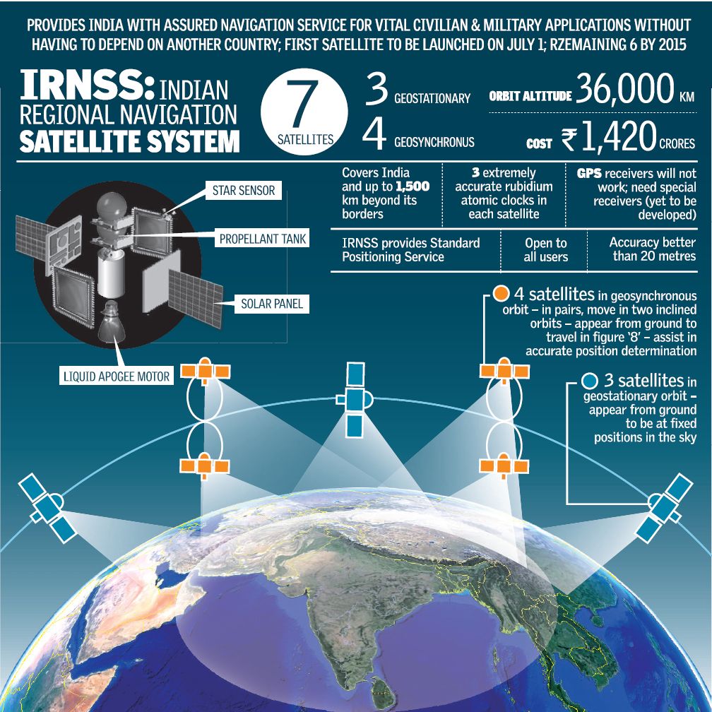
- NavIC, or Navigation with Indian Constellation, is an independent stand-alone navigation satellite system developed by the Indian Space Research Organisation (ISRO).
- NavIC was originally approved in 2006 at a cost of $174 million. It was expected to be completed by late 2011 but only became operational in 2018.
- NavIC consists of eight satellites and covers the whole of India’s landmass and up to 1,500 km (930 miles) from its boundaries.
- Currently, NavIC’s use is limited. It is being used in public vehicle tracking in India, for providing emergency warning alerts to fishermen venturing into the deep sea where there is no terrestrial network connectivity, and for tracking and providing information related to natural disasters.
- Enabling it in smartphones is the next step India is pushing for
7. Others Countries Satellites
Several countries operate or have operated satellite navigation systems similar to GPS. Some of these systems include:
-
GLONASS (Global Navigation Satellite System): Developed by Russia, GLONASS is a satellite navigation system that provides global coverage. It's similar to GPS and operates with a constellation of satellites. GLONASS is widely used in Russia and by other countries for various applications.
-
Galileo: Developed by the European Union and the European Space Agency, Galileo is another global satellite navigation system. It aims to provide highly accurate positioning and timing information. Galileo is intended to be interoperable with GPS and other systems to enhance overall navigation capabilities.
-
BeiDou Navigation Satellite System (BDS): Developed by China, BeiDou is another satellite navigation system that aims to provide global coverage. It has been operational in China and surrounding regions and has expanded its coverage to become a global system.
-
NavIC (Navigation with Indian Constellation): Developed by India, NavIC is a regional satellite navigation system designed to provide accurate positioning in India and surrounding regions.
These satellite navigation systems function similarly to GPS, employing constellations of satellites and ground control stations to provide precise positioning, navigation, and timing information to users on Earth. Many modern receivers can utilize signals from multiple satellite systems simultaneously, improving accuracy, availability, and reliability for navigation purposes
7. Way forward
GPS has evolved from a purely military technology into an integral part of everyday life, powering various industries and navigation systems worldwide. Its accuracy and reliability continue to improve with ongoing technological advancements
|
Previous Year Questions 1.In which of the following areas can GPS technology be used? (UPSC CSE 2018) 1. Mobile phone operations 2. Banking operations 3. Controlling the power grids Select the correct answer using the code given below: A.1 only B.2 and 3 only C.1 and 3 only D.1, 2 and 3 Answer (D) 2.With reference to the Indian Regional Navigation Satellite System (IRNSS), consider the following statements: (UPSC CSE 2018) 1. IRNSS has three satellites in geostationary and four satellites in geosynchronous orbits. 2. IRNSS covers entire India and about 5500 sq. km beyond its borders. 3. India will have its own satellite navigation system with full global coverage by the middle of 2019. Which of the statements given above is/are correct? A. 1 Only B.1 and 2 only C.2 and 3 only D. None Answer (A)
1.Why is Indian Regional Navigational Satellite System (IRNSS) needed? How does it help in navigation? (2018) |
Source: The Hindu
VOLCANOES
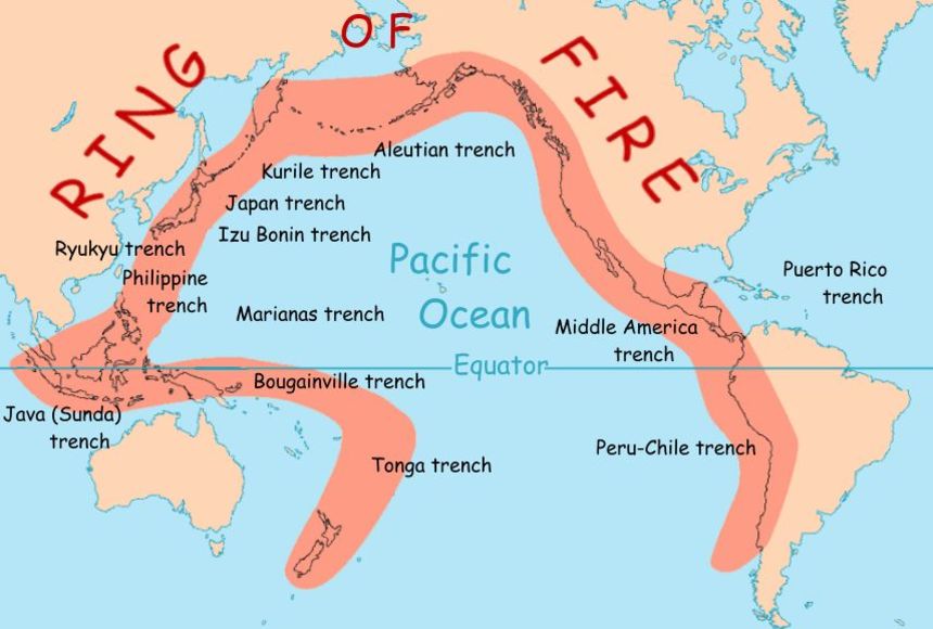
The Marapi volcano, located in West Sumatra, Indonesia, is part of the Pacific Ring of Fire. The Ring of Fire is a horseshoe-shaped area in the Pacific Ocean basin where a large number of earthquakes and volcanic eruptions occur. It's characterized by active tectonic plate boundaries, including subduction zones, where one tectonic plate is forced beneath another.
Marapi is one of Indonesia's most active volcanoes and stands about 2,891 meters (9,485 feet) tall. It's situated near the city of Bukittinggi and has a history of frequent eruptions. While some of its eruptions have been relatively small and non-explosive, it has occasionally produced more significant eruptions with ash plumes and pyroclastic flows.
The region surrounding Marapi and much of Indonesia, in general, is part of the Pacific Ring of Fire due to the complex tectonic activity in the area. The Indo-Australian Plate is subducting beneath the Eurasian Plate, leading to seismic and volcanic activity along the Sumatran Fault and other associated fault lines.
The Pacific Ring of Fire is known for its high seismic and volcanic activity, housing a majority of the world's active volcanoes and experiencing a large number of earthquakes. This area's geological dynamics make it prone to geological hazards, but it also provides valuable insights into plate tectonics and volcanic activity for scientific research
3. Volcanoes and Volcanic Landforms
Volcanoes are natural features on Earth's surface that form when magma (molten rock beneath the Earth's crust) erupts through openings or vents. The erupted materials, including lava, ash, gases, and pyroclastic flows, accumulate around the vent, building up and forming various volcanic landforms. Here are some key volcanic landforms:
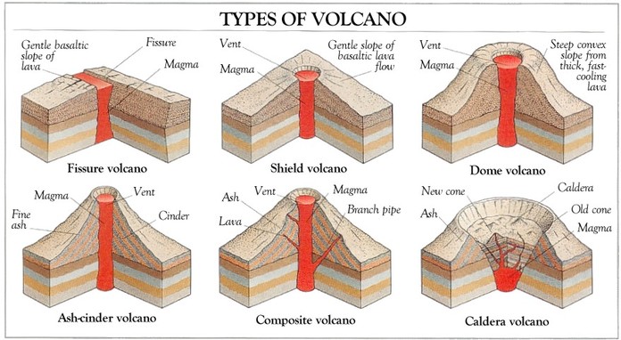
Shield Volcanoes: These are broad, gently sloping volcanoes characterized by their low viscosity lava, which flows easily. They're built up by numerous eruptions of thin, runny lava. Examples include Mauna Loa in Hawaii and the Galápagos Islands' volcanoes.
Stratovolcanoes (Composite Volcanoes): These are steep-sided, conical volcanoes built by multiple layers of lava, ash, and volcanic rocks. They are often associated with explosive eruptions due to their viscous lava. Famous examples include Mount St. Helens in the United States, Mount Fuji in Japan, and Mount Vesuvius in Italy.
Cinder Cone Volcanoes: These are small, steep-sided volcanoes formed from ejected lava fragments that pile up around the vent. They usually have a bowl-shaped crater at the summit. Paricutin in Mexico is a well-known cinder cone volcano.
Calderas: These are large, basin-shaped depressions formed after massive eruptions, where the volcano's summit collapses into the emptied magma chamber. Crater Lake in Oregon, USA, is a prime example of a caldera.
Lava Plateaus: These are vast flat areas created by successive lava flows that cover large areas of land. The Deccan Plateau in India and the Columbia River Plateau in the United States are examples of lava plateaus.
Volcanic Islands: Many islands around the world, like Hawaii, Japan, and the Philippines, were formed by volcanic activity. These islands were created as volcanoes erupted underwater and gradually built up above sea level.
Volcanic Craters: Formed at the summit of some volcanoes, these bowl-shaped depressions are created either by explosions or the collapse of the volcano's summit following an eruption.
Volcanic landforms vary based on factors like the type of eruption, the composition of the lava, and the frequency of eruptions. They contribute significantly to the Earth's landscape and often provide fertile soils and valuable resources, while also posing risks to nearby populations due to potential eruptions and associated hazards
4. Types of Volcanoes
Volcanoes come in various types, each formed by different eruptive processes and materials. Here are the main types of volcanoes:
Shield Volcanoes: These volcanoes have broad, gentle slopes due to the relatively fluid lava (low viscosity) they produce. Eruptions from shield volcanoes tend to be non-explosive and result in the flowing of lava over large distances. Examples include Mauna Loa and Mauna Kea in Hawaii.
Stratovolcanoes (Composite Volcanoes): Stratovolcanoes are tall, steep-sided cones formed by alternating layers of lava, ash, and volcanic rocks. They often produce explosive eruptions due to the higher viscosity of their lava. Mount St. Helens in the United States and Mount Fuji in Japan are examples of stratovolcanoes.
Cinder Cone Volcanoes: These small, steep-sided volcanoes are formed from the accumulation of pyroclastic material (such as ash, cinders, and volcanic rocks) ejected during eruptions. They usually have a bowl-shaped crater at the summit. Paricutin in Mexico is a famous cinder cone volcano.
Lava Domes: Lava domes are created by the slow extrusion of highly viscous lava. They form rounded mounds often found within the craters of larger volcanoes. Lava domes, such as Mount St. Helens' post-eruption dome, can be highly unstable and prone to collapse.
Complex Volcanoes: These are composite volcanoes that exhibit multiple vents and overlapping cones. They're formed by the accumulation of materials from various eruptions over time. Mount Rainier in the United States is an example of a complex volcano.
Submarine Volcanoes: Found underwater, these volcanoes create seamounts or volcanic islands. They can form chains, like the Hawaiian-Emperor seamount chain, as tectonic plates move over hotspots beneath the Earth's crust.
Supervolcanoes: These are rare but extremely powerful volcanoes capable of producing colossal eruptions. They form immense calderas after catastrophic explosions that empty the magma chamber. Yellowstone Caldera in the United States is an example of a supervolcano
5. Relation among Plate Tectonics, Volcanoes and Earthquake
Plate tectonics, volcanoes, and earthquakes are interconnected and are all part of the Earth's dynamic processes.

Plate Tectonics: The Earth's lithosphere (the outermost layer) is divided into several large and small plates that float on the semi-fluid asthenosphere beneath them. These plates are in constant motion, driven by forces like mantle convection, and this movement is known as plate tectonics.
Volcanoes: Volcanoes are closely associated with plate boundaries, where tectonic plates interact. There are three primary types of plate boundaries:
-
-
Divergent Boundaries: At divergent boundaries, plates move away from each other. Magma from the mantle rises to fill the gap, solidifies, and creates new crust. This process forms mid-ocean ridges, where underwater volcanoes and volcanic activity occur.
-
Convergent Boundaries: At convergent boundaries, plates move toward each other. When an oceanic plate collides with a continental plate or another oceanic plate, the denser oceanic plate sinks beneath the lighter plate in a process called subduction. The sinking plate melts as it descends into the mantle, leading to the formation of magma that rises to the surface, resulting in explosive volcanoes. Examples include the Andes and the Cascades.
-
Transform Boundaries: At transform boundaries, plates slide past each other horizontally. While these boundaries are not associated with volcanic activity directly, the stress buildup and release along these boundaries often cause earthquakes.
-
Thus, the movement and interaction of tectonic plates at plate boundaries create conditions conducive to both volcanic eruptions and seismic activity (earthquakes). The locations and types of volcanoes and earthquakes are influenced by the specific plate boundary and the nature of the plate movement at that boundary. Overall, plate tectonics serve as the underlying mechanism that connects the occurrence of volcanoes and earthquakes on Earth
6. How can volcanic eruptions affect the environment and natural ecosystem?
Volcanic eruptions can have significant impacts on the environment and natural ecosystems in several ways:
Air Quality: Eruptions release gases such as sulfur dioxide, carbon dioxide, hydrogen sulfide, and others. These gases can contribute to air pollution, leading to acid rain formation, smog, and the potential for respiratory issues in humans and animals.
Climate Effects: Volcanic ash and gases can reach the upper atmosphere, where sulfur dioxide reacts with water vapor to form sulfuric acid aerosols. These aerosols can reflect sunlight, leading to a cooling effect on the Earth's surface. However, this effect is temporary and can be followed by a period of warming due to greenhouse gases emitted during the eruption.
Ash Fallout: Volcanic ash can blanket large areas, affecting vegetation by blocking sunlight, damaging crops, and contaminating water sources. Heavy ashfall can collapse roofs, disrupt transportation, and damage infrastructure.
Lahars and Mudflows: Eruptions can melt snow and ice on a volcano's slopes, generating lahars (volcanic mudflows) that carry debris, ash, and rocks downslope, potentially devastating nearby communities and ecosystems.
Ecosystem Disturbance: Volcanic eruptions can destroy habitats, vegetation, and animal populations. However, some ecosystems are adapted to volcanic activity and may even benefit from the nutrient-rich volcanic soils that support new growth over time.
Water Contamination: Ash and volcanic materials can contaminate water sources, affecting aquatic life and making water unsafe for consumption.
Global Effects: Major volcanic eruptions, especially so-called "supervolcano" eruptions, can release vast amounts of ash and gases into the atmosphere, potentially leading to short-term global climate effects, including temperature drops and altered weather patterns
|
For Prelims: Indian and World Geography-Physical, Social, Economic Geography of India and the World
For Mains: General Studies I: Important Geophysical phenomena such as earthquakes, Tsunami, Volcanic activity, cyclone etc., geographical features and their location-changes in critical geographical features and in flora and fauna and the effects of such changes
|
ASPIRATIONAL DISTRICTS PROGRAMME
1. Context
2. What is the Aspirational District Programme?
The Aspirational Districts Programme (ADP) is a flagship initiative of the Indian government, launched in January 2018, with the ambitious goal of rapidly transforming 112 of India's most underdeveloped districts across 27 states. These districts are deemed "aspirational" because they have the potential to achieve significant progress with focused interventions.
The ADP adopts a holistic approach, focusing on five key areas crucial for development:
- Health & Nutrition: Aiming to improve access to quality healthcare, reduce infant mortality and malnutrition rates, and empower women with better health outcomes.
- Education: Striving to ensure all children are enrolled in schools, enhance learning outcomes, and bridge the literacy gap.
- Agriculture & Water Resources: Promoting sustainable farming practices, boosting agricultural productivity, and ensuring water security for improved livelihoods.
- Financial Inclusion & Skill Development: Empowering individuals through financial literacy, access to banking services, and skill training for better employment opportunities.
- Basic Infrastructure: Strengthening core infrastructure like roads, electricity, sanitation, and digital connectivity, which are essential for basic needs and economic growth.
3. What are the 49 indicators of aspirational districts?
The 49 indicators of aspirational districts cover various sectors and provide a comprehensive assessment of the development progress in these areas. Here is a broad overview of the key indicators:
- Health and Nutrition: Maternal Mortality Ratio (MMR), Neonatal Mortality Rate (NMR), Under-5 Mortality Rate (U5MR), Full Immunization Coverage, Institutional Delivery Rate, Antenatal Care Coverage, Exclusive Breastfeeding Coverage, Stunting (Height-for-Age) among Children, Wasting (Weight-for-Height) among Children, Anaemia among Children and Anaemia among Women.
- Education: Gross Enrollment Ratio (GER) in Elementary Education, Transition Rate from Primary to Upper Primary, Dropout Rate in Upper Primary Schools, Average Learning Outcomes in Mathematics (Class 3, 5, and 8), Average Learning Outcomes in Language (Class 3, 5, and 8) and School Infrastructure Index.
- Agriculture and Water Resources: Crop Diversification, Sustainable Agriculture Practices and Completion of Projects under Pradhan Mantri Krishi Sinchai Yojana (PMKSY).
- Financial Inclusion: Banking Penetration, Households with Bank Accounts, Households with Access to Credit and Households with Access to Insurance.
- Basic Infrastructure: Rural Road Connectivity, Household Toilets, Households with Electricity and Piped Water Supply.
- Skill Development: Number of Youth Trained, Employment Rate and Entrepreneurship Development.
- Agriculture and Allied Activities: Fishery Development and Livestock Development.
- Financial Inclusion: Progress under Pradhan Mantri Jan Dhan Yojana (PMJDY) and Penetration of Micro Units.
- Basic Infrastructure: Rural Road Connectivity, Piped Water Supply, Household Toilets and Households with Electricity.
- Skill Development: Number of Youth Trained, Employment Rate and Entrepreneurship Development.
- Basic Infrastructure: Rural Road Connectivity, Piped Water Supply, Household Toilets and Households with Electricity.
- Skill Development: Number of Youth Trained, Employment Rate and Entrepreneurship Development.
4. The criteria for aspirational district
- The criteria for identifying aspirational districts are based on a combination of backwardness indicators and the commitment of the district administration to implement development initiatives effectively. The key criteria include:
- The districts selected as aspirational districts typically exhibit relatively low scores on the NITI Aayog's Development Index or other relevant indices. These indices assess various socio-economic parameters, and districts with lower scores indicate a need for focused development interventions.
- The willingness of the district administration to improve and a demonstrated commitment to implementing development initiatives effectively are crucial criteria. Districts that actively engage in and prioritize developmental efforts are more likely to be selected as aspirational districts.
- Aspirational districts are expected to have the potential to quickly catch up with the national averages on key development indicators. The identification of districts with untapped potential helps in targeting interventions that can lead to accelerated development.
- The engagement of the district administration and the state government in a partnership mode with the Central Government and other stakeholders is essential. Collaborative efforts involving different levels of government and other organizations contribute to the success of the aspirational district initiatives.
5. About Aspirational Blocks Programme
The Aspirational Blocks Programme (ABP) is a recent initiative building upon the success of the Aspirational Districts Programme (ADP). Launched in 2021, the ABP aims to achieve similar transformative goals at the block level, focusing on India's most underdeveloped 500 blocks across 25 states.
Key Features of Aspirational Block Programme
- The ABP identifies and prioritizes 500 blocks across all aspirational districts, based on specific criteria like poverty levels, social indicators, and infrastructure gaps.
- Similar to the ADP, the ABP emphasizes the convergence of existing government schemes and programs to avoid duplication and maximize impact.
- The program focuses on measurable outcomes rather than just outputs, ensuring interventions have a tangible positive effect on people's lives.
- Leveraging technology plays a crucial role in data collection, monitoring progress, and facilitating communication between stakeholders.
- Active participation and ownership by local communities are essential for the ABP's success. This includes involving panchayats, civil society organizations, and community leaders in planning, implementation, and monitoring.
6. The rationality behind Aspirational Blocks Programme (ABP)
The rationality behind the Aspirational Blocks Programme (ABP) is multifaceted, encompassing both practical considerations and aspirational goals:
Addressing Development Disparity within Districts
- The ADP successfully tackled development gaps at the district level, but disparities persisted within aspirational districts. The ABP focuses on the most underdeveloped blocks within these districts, aiming to ensure no block gets left behind.
- By zooming in on specific blocks, the ABP can tailor interventions to address their unique challenges and needs more effectively. This avoids a one-size-fits-all approach and potentially maximizes impact.
- The ABP aims for saturation of essential services across various domains, ensuring all residents within a block have access to basic healthcare, education, sanitation, etc., regardless of their location or socioeconomic background.
Boosting Grassroots Participation and Empowerment
- The ABP empowers communities by actively involving panchayats, civil society organizations, and local leaders in the program. This fosters a sense of ownership and accountability, leading to more sustainable development outcomes.
- Digital platforms and tools are used to enhance communication, transparency, and data accessibility. This empowers communities to hold authorities accountable and advocate for their needs.
- The ABP invests in skill development and capacity building for local stakeholders, equipping them with the knowledge and tools to plan, implement, and monitor development initiatives.
Leveraging Technology and Data for Efficiency
- Digital platforms enable real-time data collection and progress tracking, allowing for quick course correction and adjustments based on actual needs and outcomes.
- By analyzing data from various sources, the ABP can identify bottlenecks, prioritize interventions, and allocate resources more efficiently.
- The ABP promotes testing and adopting innovative solutions that can be replicated and scaled up across different blocks and districts, maximizing impact and cost-effectiveness.
7. The difference between the Aspirational Blocks Programme and Aspirational District Programme
| Feature | Aspirational Blocks Programme (ABP) | Aspirational District Programme (ADP) |
| Scale | Block-level | District-level |
| Emphasis | Saturation of essential services | Broader development goals (poverty reduction, social indicators, economic growth) |
| Community engagement | Strong emphasis on local ownership and participation | Encouraged, but primarily government-driven |
| Technology & data | Central role for digital platforms and real-time data | Less emphasis, relies more on traditional methods |
| Outcome-driven approach | Measurable outcomes like access to basic needs |
Focus on achieving output targets within broader development framework
|
|
For Prelims: Aspirational District Programme, Aspirational Blocks Programme, NITI Aayog
For Mains:
1. Explain the significance of the Aspirational District Programme (ADP) in the context of governance and development in India. (250 Words)
|
|
Previous Year Questions
1. The ‘Aspirational District Programme (ADP)’ was launched by the Prime Minister Narendra Modi on January 5, 2018. Which of the following is not part of ‘Aspirational District Programme '? (RRB Officer Scale-I Mains 2021)
A. It is a special initiative to rapidly transform 115 identified districts that have shown relatively lesser progress in key social areas
B. The Baseline Ranking was released by NITI Aayog on April 1, 2018.
C. NITI Aayog in partnership with the Government of Andhra Pradesh has created a dashboard for monitoring the real-time progress of the districts.
D. There are 70 Key Performance Indicators (KPIs).
E. The aim is to realise the vision of ‘SabkaSaath, SabkaVikas’, and ensure that India’s growth process remains inclusive.
2. Atal Innovation Mission is set up under the (UPSC 2019) (a) Department of Science and Technology
3. The Government of India has established NITI Aayog to replace the (UPSC 2015) A. Human Rights Commission
B. Finance Commission
C. Law Commission
D. Planning Commission
Answers: 1-D, 2-C, 3-D |
KRISHNA RIVER MANAGEMENT BOARD (KRMB)
- The Krishna River Management Board (KRMB) is a statutory body established under the Andhra Pradesh Reorganization Act of 2014.
- Its primary purpose is to oversee the management, regulation, and distribution of water resources from the Krishna River among the states of Andhra Pradesh and Telangana, as well as other regions that fall within the river basin.
- KRMB plays a crucial role in implementing various projects, managing water-sharing agreements, resolving disputes between the states, and ensuring equitable distribution of water resources among the stakeholders.
- It functions to maintain a balance in the utilization of water for irrigation, drinking water supply, hydropower generation, and other purposes while considering the needs of the various regions and addressing potential conflicts that may arise among the stakeholders
- The KRMB is headed by a Chairman, who is a senior officer of the Indian Administrative Service (IAS). The Chairman is assisted by a Member Secretary and a team of technical and administrative officers.
- The KRMB has four regional offices, located in Cuddapah, Kurnool, Vijayawada, and Hyderabad. These offices are responsible for monitoring the water resources in their respective regions and implementing the KRMB's decisions
3.Krishna River Basin
The Krishna River Basin is one of the major river basins in India, encompassing a vast area and playing a significant role in the water resources of the country. The Krishna River, originating in the Western Ghats of Maharashtra, flows through several states, primarily Maharashtra, Karnataka, Telangana, and Andhra Pradesh, before draining into the Bay of Bengal.
The basin covers various terrains, from the mountainous regions where the river originates to the plains where it meanders through, supporting agriculture, industry, and livelihoods along its course. The river basin is vital for irrigation, hydropower generation, drinking water supply, and supporting diverse ecosystems
Given the importance of the Krishna River and its tributaries, efficient management and equitable distribution of water resources among the states sharing the basin become crucial. The Krishna River Basin has been a subject of water disputes and has seen the establishment of regulatory bodies like the Krishna River Management Board (KRMB) to manage water allocation, resolve conflicts, and ensure fair utilization of water resources among the states involved.
- Karnataka: 113,271 km2
- Telangana: 76,252 km2
- Andhra Pradesh: 76,252 km2
- Maharashtra: 69,425 km2

The Krishna River Management Board (KRMB) faces several challenges in effectively managing and regulating the Krishna River Basin. Some of these challenges include:
- Disputes among the states sharing the Krishna River Basin regarding the allocation and distribution of water resources are a significant challenge. Balancing the water needs of different states, especially during times of scarcity, often leads to conflicts that need to be resolved through negotiations and agreements.
- The growing population, urbanization, and expanding agriculture put pressure on water resources. Balancing the increasing demands for irrigation, drinking water supply, industrial use, and hydropower generation becomes challenging, particularly during dry seasons or drought periods.
- Climate change brings uncertainties in rainfall patterns, leading to irregularities in water availability. Changes in precipitation levels, increased frequency of extreme weather events like droughts or floods, and rising temperatures can disrupt the natural flow of the river and affect water availability.
- Ensuring environmental sustainability and maintaining the ecological balance of the Krishna River Basin is essential. Balancing the needs of human activities with preserving the river's ecosystem and biodiversity poses a significant challenge.
- Developing and managing infrastructure such as dams, reservoirs, canals, and other water diversion projects require careful planning to optimize water usage and minimize negative impacts on communities and the environment.
- Ensuring effective governance, transparent decision-making, and the proper implementation of water management policies and agreements among the states is crucial for the KRMB. Coordination and cooperation among the states and stakeholders are essential for the successful functioning of the board
The Krishna River, one of India's longest rivers, is sustained by a network of tributaries that contribute to its immense volume and flow. These tributaries originate from various regions and play a crucial role in irrigating agricultural lands, supporting diverse ecosystems, and shaping the river's overall hydrological regime.
Here's a comprehensive list of the major tributaries of the Krishna River:
Left Bank Tributaries:
-
Yerla River: Emerging from the Mahadev Hills in Maharashtra, the Yerla River joins the Krishna River near Sangli, Maharashtra.
-
Bhima River: Rising from the Bhima Shankara Hills in Karnataka, the Bhima River is the Krishna River's longest tributary, stretching over 800 kilometers. It joins the Krishna River near Raichur, Karnataka.
-
Dindi River: Originating from the Nallamala Hills in Andhra Pradesh, the Dindi River joins the Krishna River near Srisailam, Andhra Pradesh.
-
Musi River: Flowing from the Ananthagiri Hills in Telangana, the Musi River joins the Krishna River near Hyderabad, Telangana.
-
Paleru River: Rising from the Nallamala Hills in Andhra Pradesh, the Paleru River joins the Krishna River near Machilipatnam, Andhra Pradesh.
-
Munneru River: Originating from the Nallamala Hills in Andhra Pradesh, the Munneru River joins the Krishna River near Vijayawada, Andhra Pradesh.
Right Bank Tributaries:
-
Kudali (Niranjana) River: Emerging from the Sahyadri Hills in Maharashtra, the Kudali River joins the Krishna River near Kolhapur, Maharashtra.
-
Venna River: Originating from the Sahyadri Hills in Maharashtra, the Venna River joins the Krishna River near Satara, Maharashtra.
-
Koyna River: Flowing from the Mahadeo Hills in Maharashtra, the Koyna River is known for its spectacular waterfalls and hydroelectric power projects. It joins the Krishna River near Chiplun, Maharashtra.
-
Panchganga River: Formed by the confluence of five rivers – Krishna, Vishnu, Koyna, Bhima, and Ghataprabha – the Panchganga River joins the Krishna River near Sangli, Maharashtra.
-
Dhudhganga River: Rising from the Mahabaleshwar region in Maharashtra, the Dudhganga River joins the Krishna River near Krishnagiri, Karnataka.
-
Ghataprabha River: Originating from the Sahyadri Hills in Maharashtra, the Ghataprabha River is a significant tributary, joining the Krishna River near Vijayapura, Karnataka.
-
Malaprabha River: Emerging from the Sahyadri Hills in Karnataka, the Malaprabha River joins the Krishna River near Bagalkot, Karnataka.
-
Tungabhadra River: Formed by the confluence of the Tungabhadra and Bhadra rivers, the Tungabhadra River is a major tributary, joining the Krishna River near Kurnool, Andhra Pradesh

|
Previous Year Questions
1.Which is the source of Krishna river ? (SSC CHSL 2020)
A.Amarkantak
B.Tala
C.Mahabaleshwar
D.Multai
Answer (C)
|


