
1. Context
Six people, including an Assam Forest Guard, were killed and several others injured during an alleged clash between the Assam Police and a mob, in an area bordering the West Karbi Anglong district of Assam and Mukroh village in Meghalaya's West Jaintia Hills. The Assam Police has claimed they opened fire in self-defence after a mob surrounded them when they were trying to intercept a truck allegedly smuggling timber.
2. Historical Background
During British rule, undivided Assam included present-day Nagaland, Arunachal Pradesh, Meghalaya, and Mizoram. Meghalaya was carved out in 1972; its boundaries were demarcated as per the Assam Reorganisation (Meghalaya) Act of 1969, but have held a different interpretation of the border since.
In 2011, the Meghalaya government had identified 12 areas of difference with Assam, spread over approximately 2,700 sq km.
3. Border Dispute
3.1 Assam Reorganisation Act 1969-Assam and Meghalaya share an 885 km border. In 1970, Meghalaya was carved out of Assam as an autonomous state. In 1972, Meghalaya became a full-fledged state following the Assam Reorganisation (Meghalaya) Act of 1969
This was the beginning of the border problem as the Meghalaya government found the Act unacceptable.
3.2 Land Dispute Points-As many as 12 land dispute points, along the border of these two states, have been a bone of contention. These include Langpih, Upper Tarabari, Gazang reserve forest, Hashim, Borduar, Boklapara, Nongwah, Matamur, Khanapara-Pilangkata, Deshdemoreah Block I and Block II, Khanduli and Retacherra. Six of these areas have found some type of resolution in recent times after a memorandum of understanding (MoU) was signed between the two states.
Among the 12 areas, Langpih in the West Garo Hills bordering the Kamrup district of Assam is a major flashpoint. Langpih was part of the Kamrup district during the British colonial period, but post-Independence, it became part of the Garo Hills and Meghalaya.
Meghalaya claims that the border problem in Langpih has been created by Assam, which has often set up police posts there
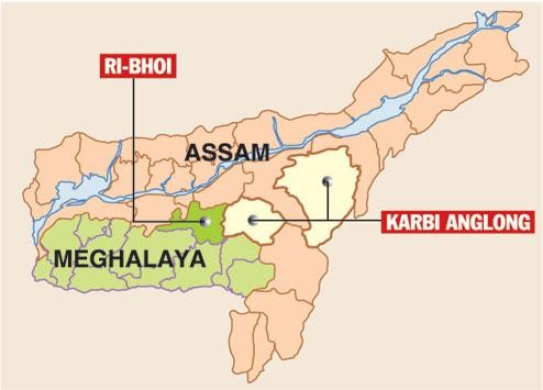
4.1 Gopinath Bordoloi committee1951-Bordoloi Committee’s recommendation that Blocks I and II of Jaintia Hills (Meghalaya) be transferred to the Mikir Hill (Karbi Anglong) district of Assam, besides some areas from Meghalaya’s Garo Hills to Goalpara district of Assam. The 1969 Act is based on these recommendations which Meghalaya rejects claiming these areas originally belong to the Khasi –Jaintia hills. On the other hand, Assam says Meghalaya does not have the requisite documents to prove these areas historically belonged to Meghalaya.
In 1983, a joint official committee was formed to address the border issues. The panel recommended that the Survey of India should re-delineate the border, teaming up with both states
4.2 Justice YV Chandrachud Panel1985-In 1991, about 100 km of the border was demarcated with the help of the Survey of India, but Meghalaya cried foul
4.3 Boundary commission 2011-In 2011, the Meghalaya Assembly passed a resolution for the intervention of the Centre and the establishment of a boundary commission.
The Centre asked the two governments to appoint nodal officers to discuss the dispute. In 2019, Meghalaya urged the Supreme Court to direct the Centre to resolve the dispute but the petition was turned down.
4.4 Draft Resolution-On January 29 this year, Assam and Meghalaya signed a draft resolution. It was the first step towards resolving a 50-year-old dispute.
4.5 Memorandum of Understanding signed on March 29, a historic MoU was signed between Assam Chief Minister Himanta Biswa Sarma and his Meghalaya counterpart Conrad K Sangma in the presence of Home Minister Amit Shah in New Delhi.
The first phase saw the closure of six disputed sectors in which out of 36.79 sq km of the disputed area taken up for settlement in the first phase, Assam would get full control of 18.46 sq km and Meghalaya of 18.33 sq km.
The remaining six areas include villages in disputed blocks 1 and 2 transferred from the then United Khasi and Jaintia districts to Assam’s Karbi Anglong district for administrative convenience in the 1950s.
On August 22 this year, the second phase of border talks was held with the two states deciding to form three regional committees to resolve issues regarding the remaining six disputed areas.
For Mains
| Mains Question –1.what are the grounds for the border dispute between Assam and Meghalaya? Trace the efforts made to resolve the issue. |

