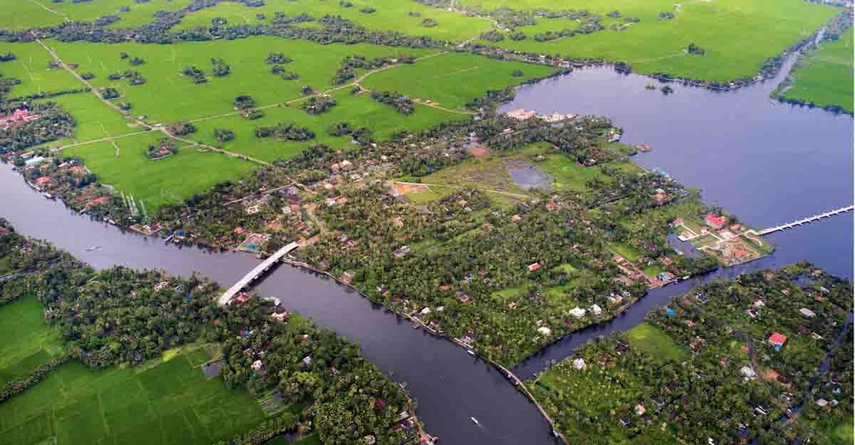
KUTTANAD WETLANDS
Source: Frontline
Context
Kuttanad in Kerala is a unique wetland under threat from extreme climate events and ecological destruction and urgently needs a long-term strategy.
Kuttanad Wet Land
- Kuttanad is a unique wetland complex in Central Kerala.
- It is under severe ecological threat from both climate change and policy impasse.
- A land that lies below sea level, it has been studied and debated intensely over the years.
- It is the downstream deltaic formation of five inflowing rivers in the Western Ghats.
- These rivers debouch into the Vembanad lake, one of the largest brackish-water lakes in the country and flow into the Lakshadweep Sea at Kochi.
- It forms part of the ecological continuum that links the Western ghats and the sea.
- Kuttanad is part of the larger Vembanad Kol wetland ecosystem and is a Ramsar site.
- It is under the convention on wetlands, adopted in Ramsar, Iran, in 1971, member-states designate one or more wetlands as Ramsar sites.
- The wetland is characterised by intersecting canals below-sea level paddy cultivation and a dense population (700 persons per square kilometre).
A narrow sand ridge that runs parallel to Vembanad Lake with numerous inlets. - Both seasonal and permanent (Known in Malayalam as "azhi" and "pozhi"), separate Kuttanad and the Lakshadweep Sea.
- The unique ecosystem and the resilient community inhabiting it are now on the brink of disaster as a result of climate change and the danger is exacerbated by policy stalemate.
Important points
- Many major infrastructure developments in the region were maladapted.
- Several discussions have been held on the efficacy of and unforeseen consequences caused by structures such as the TSB, the TSW and The Alappuzha-Changanassery State Highway that passes through Kuttanad.
- The CWC gave conditional clearance to the TSB, it was made clear that it was built to regulate salinity and not to prevent saltwater entry into Vembanad.
- The bund should be kept open always, except between December and March.
- To ensure the entry of salt water into the lake for facilitating fish migration and mussel breeding and to enable natural flushing of the lake through the tidal cycle.
- The lakh south of the barrier has become a stagnant pool.
- Over the years, the fish and mussel population have declined drastically, making life miserable for fishing communities.
- During the summer paddy season, the salinity level reaches 1 ppt (parts per thousand) is the tolerance level of the paddy grown in Kuttanad, shutters may be downed.
- During the December-March period, Shutters need not be down all the time.
- The salinity is less than 0.9 ppt and considering the tidal level at the Kochi mouth as well, the shutters may be opened.
- The twin challenges are flooding caused by extreme precipitation in the upper catchments of the inflowing rivers and the rise in sea levels caused by global warming.
Floods
- The flooding is caused by extreme precipitation in the upper catchments of the inflowing rivers and the rise in sea levels by global warming.
- 2018 flood was considered a once-in-a-century aberration, reminiscent of the 1924 Devikulam Strom.
- Unusually extreme rainfall in the last four years and the intensity of summer rains in 2020 and 2022 destroyed the entire summer paddy crop, the main crop in Kuttanad.
- The rising sea levels at Kochi will be even more calamitous to the region.
- The seasonal flooding and saltwater intrusion are an accepted reality in this low-lying belt.
- The formulation of a climate-resilient development strategy that integrates scientific and indigenous knowledge has become immediate and indispensable.
Studies and implementation
The Central Water Commission's (CWC) report
- The absence of storage reservoirs upstream on the rivers flowing into Kuttanad.
- The shrinkage of carrying capacity of Vembanad Lake and the Thottappally Spillway's (TSW) reduced capacity as factors that may have worsened the flooding in Kuttanad.
Recommendations
- Widening the lead channel to the spillway, which was built in the early 1950s to redirect flood waters to the sea before they reached lower Kuttanad and Vembanad, but never achieved its planned capacity.
- To enhance the upstream storage of the Pamaba and Achankovil basins to moderate floods.
- Desilting of a stretch of the Thottappally lead channel has been attempted, but no steps have been taken to widen it.
- The banks of the lead channel are densely inhabited, so land acquisition may be a problem.
- There may also be considerable opposition from the public to enhancing the upstream storage.
IIT Madras and the Centre for Water Resource Development and Management (CWRDM), Kozhikode
- The modernisation of the Thanneermukkom Saltwater Barrier (TSB) and the Thottappilly spillway.
- TSB was built to regulate saltwater intrusion into Vembanad.
- The extensive study employed various methodologies, including field surveys, monitoring studies, an inspection of hydraulic structures and analysis of scenarios using numerical models.
- It proposed three alternatives to solve the flooding issue, including widening of the lead channel and removal of the sand bar at the ocean mouth in Thottappally.
- Many drainage channels were blocked due to weed infestation and the dumping of garbage.
- It recommended that cleaning the channels regularly would significantly alleviate the flooding problem and mapped the channels that urgently required improvement.
Government initiatives
- The deterioration in the aquatic environment of Vembanad Lake and the weed growth in the drainage channels have been debated for more than three decades now.
- Paddy needs fresh water, fisherfolk requires brackish water and the tourism sector wants a pristine environment to market.
- The roads in the wetland have significantly improved mobility and opened up livelihood choices.
- This is reflected in the upward mobility of the community, evident in all indicators.
- But roads without a proper drainage system in an ecosystem cause water-logging and aggravate flooding and in turn make the landscape uninhabitable.
- This happens in the absence of a specific, community-linked environmental governance framework and implementing mechanism.
- At Chilavannoor in Kochi and Cherthala, south of Kochi apartments and hotels were demolished due to violation of the coastal zone regulations.
- These structures were allowed to come up and reflect the failure of all tiers of governance from local governments up to the judiciary.
M.S. Swaminathan Research Foundation report
- The report suggested that agricultural operations be carried out in such a manner that the "Puncha" crop is harvested by March-end and the second crop by September.
- The puncha crop could have been rescued from the summer rain to a great extent.
- The TSB could have been opened and resulted in natural tidal flushing and fish migration.
- A structural shift is taking place in farming in Kuttanad with the reemergence of lease-based farming.
- Vast stretches of paddy fields are being leased out, bypassing existing ceiling limits.
- This is a post-1990S phenomenon that started in a small way but has now expanded enormously.
- This structural shift makes a mockery of regulations and restrictions.
- It also impedes the formulation of a climate-resilient development framework for the region.
Resilient Kuttanad
- Annual cropping instead of cultivation in alternate years began in the 1940s.
- With the commissioning of the TMB and TSB, it became popular to cultivate a second crop.
- In the 1960s, the entire region shifted to high-yielding varieties, starting with IR-8 Procured from the International Rice Research Organisation.
- In the late 1970s, the Rice Research Station at Mancombu developed a new strain "Bhadra". it was resistant to brown hopper attacks.
- Kuttanad swiftly shifted to Bhadra and now it has moved on to Uma, a popular variety developed by the regional station of Kerala Agricultural University with a productivity of 6-6.5 tonnes per hectare.
- The region also witnessed a sudden shift from highly polluting organochloride pesticides to non-accumulating organophosphates.
- All scientific research has shown that pesticide usage has come down drastically.


