GLOBAL POSITIONING SYSTEM (GPS)
- The Global Positioning System (GPS) is a network of satellites that orbit the Earth and provide precise location and time information to GPS receivers anywhere on or near the Earth. Originally developed by the United States Department of Defense for military applications, GPS has become widely used in various civilian applications like navigation, mapping, surveying, and outdoor activities.
- GPS works by triangulating signals from multiple satellites to determine the receiver's exact location, typically using signals from at least four satellites to pinpoint a specific position. Each satellite broadcasts signals containing its own location and the precise time the signal was transmitted.
- By measuring the time it takes for the signals to reach the receiver, the GPS device can calculate how far away each satellite is and use this information to determine its own location through a process called trilateration.
- Apart from navigation in vehicles and smartphones, GPS technology has found applications in agriculture, aviation, disaster management, tracking systems, and more due to its accuracy and reliability in determining precise geographic coordinates
3. History of GPS
The history of GPS dates back to the 1960s when the United States began developing the technology for military purposes. Here's a brief timeline of the significant milestones in GPS development:
1960s: The U.S. Department of Defense starts experimenting with satellite-based navigation systems. The system was initially called NAVSTAR (Navigation System with Timing and Ranging).
1973: Physicist and engineer Ivan Getting proposed the concept of a global positioning system using satellites in geostationary orbits. This idea later evolved into the GPS we know today.
1978: The first experimental Block-I GPS satellite was launched, initiating the development of the operational system.
1983: Korean Air Lines Flight 007, a passenger jet, was shot down after straying into Soviet airspace due to navigational errors. This incident accelerated the development and deployment of GPS for civilian use to prevent similar tragedies.
1993: GPS achieved full operational capability with a complete constellation of 24 satellites in orbit.
Late 1990s: Selective Availability (SA), intentional degradation of GPS signals for civilian users, was turned off, significantly improving the accuracy of civilian GPS receivers.
2000s: With advancements in technology, the use of GPS became widespread in various civilian applications, including navigation devices, smartphones, agriculture, surveying, and more.
Modern Developments: Over time, the system has seen upgrades, including the launch of new satellites (modernized Block IIR, IIR-M, IIF, and GPS III satellites), improved accuracy, and the integration of other satellite systems like GLONASS (Russia), Galileo (Europe), and BeiDou (China) for enhanced global coverage and accuracy.
GPS has evolved from a purely military technology into an integral part of everyday life, powering various industries and navigation systems worldwide. Its accuracy and reliability continue to improve with ongoing technological advancements
4. How does the Global Positioning System Work?
The Global Positioning System (GPS) works through a network of satellites orbiting the Earth. Here's a simplified breakdown of how GPS functions:
Satellite Constellation: The GPS system consists of at least 24 satellites orbiting the Earth. These satellites are placed in such a way that at any given time and place on Earth, there are usually multiple satellites visible in the sky.
Triangulation: A GPS receiver on the ground or in a device, such as a smartphone or a GPS unit, communicates with these satellites by receiving signals from them. To determine its location, the receiver needs signals from at least four satellites. This is because each satellite sends out signals containing information about its location and the exact time the signal was transmitted.
Calculating Distance: The GPS receiver calculates its distance from each satellite by measuring the time it takes for the signals to travel from the satellites to the receiver. Since the speed of the signal is known (the speed of light), the receiver can calculate how far away each satellite is based on the time it took for the signal to arrive.
Trilateration: Once the receiver has gathered distance measurements from at least four satellites, it uses a process called trilateration. Trilateration involves intersecting spheres (or in this case, spheres in three dimensions) to determine the precise location where the spheres intersect. In GPS, these spheres are representations of the distances from each satellite. By finding the intersection point of these spheres, the receiver can calculate its exact position on Earth in terms of latitude, longitude, and altitude.
Data Processing: Once the receiver has calculated its position based on signals from multiple satellites, it uses this information along with maps or other geographical data to display the location or provide navigational instructions to the user.
The accuracy of GPS depends on various factors like the number of satellites visible, the quality of the receiver, atmospheric conditions, and any obstructions (such as tall buildings or mountains) that might interfere with signal reception. However, modern GPS receivers can typically provide very accurate location information, often within a few meters
Satellites, especially those involved in navigation systems like GPS, rely on incredibly precise timekeeping. They achieve this accuracy through a combination of factors:
Atomic clocks: Each satellite carries multiple atomic clocks, considered the most accurate timekeeping devices ever created. These clocks tick based on the natural vibrations of atoms, resulting in minimal drift over time. Compared to regular quartz clocks, atomic clocks are millions of times more precise, losing only a few nanoseconds per day.
Ground control and synchronization: Despite their exceptional accuracy, even atomic clocks experience slight variations. Ground stations continuously monitor the satellite clocks, detecting any deviations from International Atomic Time (TAI), the global standard. Based on these measurements, the ground stations send correction signals to the satellites, keeping their clocks precisely aligned.
Relativity factor: Time itself runs slightly differently depending on factors like gravity and velocity. Satellites orbiting Earth experience weaker gravity and travel faster than stationary objects on the ground. This tiny difference, though minuscule, is accounted for in calculations to ensure accurate timekeeping. Regular adjustments are made to compensate for this relativistic effect.
Redundancy and backup systems: To ensure uninterrupted timekeeping, satellites have multiple atomic clocks. If one clock malfunctions, the others take over, minimizing disruptions. Additionally, regular maintenance and updates are performed on both ground stations and satellites to maintain optimal performance.
Through this intricate interplay of cutting-edge technology, meticulous monitoring, and clever calculations, satellites hold onto time with mind-boggling precision. This unwavering accuracy is vital not only for GPS navigation but also for scientific research, telecommunications, and financial transactions that rely on split-second timing
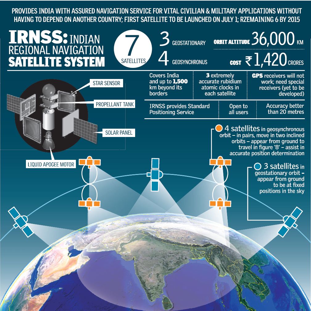
6. India's NaVIC?
- NavIC, or Navigation with Indian Constellation, is an independent stand-alone navigation satellite system developed by the Indian Space Research Organisation (ISRO).
- NavIC was originally approved in 2006 at a cost of $174 million. It was expected to be completed by late 2011 but only became operational in 2018.
- NavIC consists of eight satellites and covers the whole of India’s landmass and up to 1,500 km (930 miles) from its boundaries.
- Currently, NavIC’s use is limited. It is being used in public vehicle tracking in India, for providing emergency warning alerts to fishermen venturing into the deep sea where there is no terrestrial network connectivity, and for tracking and providing information related to natural disasters.
- Enabling it in smartphones is the next step India is pushing for
7. Others Countries Satellites
Several countries operate or have operated satellite navigation systems similar to GPS. Some of these systems include:
-
GLONASS (Global Navigation Satellite System): Developed by Russia, GLONASS is a satellite navigation system that provides global coverage. It's similar to GPS and operates with a constellation of satellites. GLONASS is widely used in Russia and by other countries for various applications.
-
Galileo: Developed by the European Union and the European Space Agency, Galileo is another global satellite navigation system. It aims to provide highly accurate positioning and timing information. Galileo is intended to be interoperable with GPS and other systems to enhance overall navigation capabilities.
-
BeiDou Navigation Satellite System (BDS): Developed by China, BeiDou is another satellite navigation system that aims to provide global coverage. It has been operational in China and surrounding regions and has expanded its coverage to become a global system.
-
NavIC (Navigation with Indian Constellation): Developed by India, NavIC is a regional satellite navigation system designed to provide accurate positioning in India and surrounding regions.
These satellite navigation systems function similarly to GPS, employing constellations of satellites and ground control stations to provide precise positioning, navigation, and timing information to users on Earth. Many modern receivers can utilize signals from multiple satellite systems simultaneously, improving accuracy, availability, and reliability for navigation purposes
7. Way forward
GPS has evolved from a purely military technology into an integral part of everyday life, powering various industries and navigation systems worldwide. Its accuracy and reliability continue to improve with ongoing technological advancements
|
Previous Year Questions 1.In which of the following areas can GPS technology be used? (UPSC CSE 2018) 1. Mobile phone operations 2. Banking operations 3. Controlling the power grids Select the correct answer using the code given below: A.1 only B.2 and 3 only C.1 and 3 only D.1, 2 and 3 Answer (D) 2.With reference to the Indian Regional Navigation Satellite System (IRNSS), consider the following statements: (UPSC CSE 2018) 1. IRNSS has three satellites in geostationary and four satellites in geosynchronous orbits. 2. IRNSS covers entire India and about 5500 sq. km beyond its borders. 3. India will have its own satellite navigation system with full global coverage by the middle of 2019. Which of the statements given above is/are correct? A. 1 Only B.1 and 2 only C.2 and 3 only D. None Answer (A)
1.Why is Indian Regional Navigational Satellite System (IRNSS) needed? How does it help in navigation? (2018) |
Source: The Hindu


